Estimated Value: $349,000 - $397,000
2
Beds
2
Baths
1,063
Sq Ft
$349/Sq Ft
Est. Value
About This Home
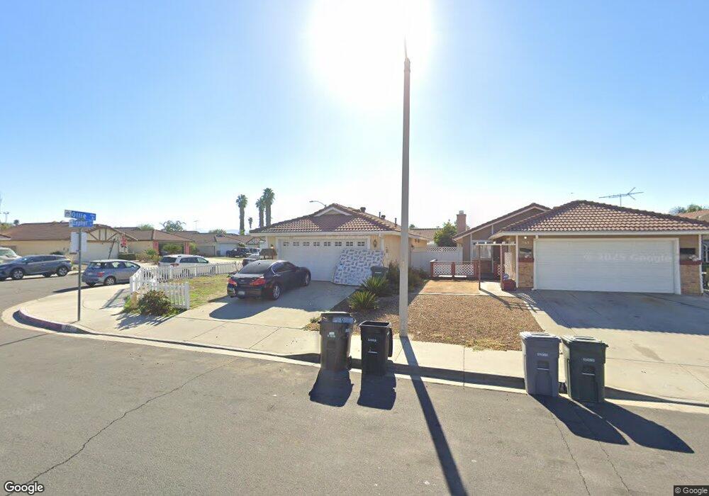
This home is located at 771 Zephyr Cir, Hemet, CA 92543 and is currently estimated at $371,500, approximately $349 per square foot. 771 Zephyr Cir is a home located in Riverside County with nearby schools including Fruitvale Elementary School, Rancho Viejo Middle School, and Tahquitz High School.
Ownership History
Date
Name
Owned For
Owner Type
Purchase Details
Closed on
Jun 22, 2017
Sold by
Gwyn Robert D and Gwyn Robert D
Bought by
Yorkshire House Llc
Current Estimated Value
Purchase Details
Closed on
Oct 31, 2001
Sold by
Gwyn Chanpen
Bought by
Gwyn Robert D
Home Financials for this Owner
Home Financials are based on the most recent Mortgage that was taken out on this home.
Original Mortgage
$65,500
Interest Rate
6.84%
Purchase Details
Closed on
Sep 25, 2001
Sold by
Mckinney John R and Mckinney Barbara J
Bought by
Gwyn Robert D
Home Financials for this Owner
Home Financials are based on the most recent Mortgage that was taken out on this home.
Original Mortgage
$65,500
Interest Rate
6.84%
Purchase Details
Closed on
Aug 6, 2001
Sold by
Hood Cleopatra M
Bought by
Mckinney John R and Mckinney Barbara J
Home Financials for this Owner
Home Financials are based on the most recent Mortgage that was taken out on this home.
Original Mortgage
$65,500
Interest Rate
6.84%
Create a Home Valuation Report for This Property
The Home Valuation Report is an in-depth analysis detailing your home's value as well as a comparison with similar homes in the area
Home Values in the Area
Average Home Value in this Area
Purchase History
| Date | Buyer | Sale Price | Title Company |
|---|---|---|---|
| Yorkshire House Llc | $166,000 | First American Title Company | |
| Gwyn Robert D | -- | New Century Title Company | |
| Gwyn Robert D | $85,500 | New Century Title Company | |
| Mckinney John R | -- | -- |
Source: Public Records
Mortgage History
| Date | Status | Borrower | Loan Amount |
|---|---|---|---|
| Previous Owner | Gwyn Robert D | $65,500 |
Source: Public Records
Tax History Compared to Growth
Tax History
| Year | Tax Paid | Tax Assessment Tax Assessment Total Assessment is a certain percentage of the fair market value that is determined by local assessors to be the total taxable value of land and additions on the property. | Land | Improvement |
|---|---|---|---|---|
| 2025 | $3,138 | $237,913 | $40,617 | $197,296 |
| 2023 | $3,138 | $228,677 | $39,041 | $189,636 |
| 2022 | $2,830 | $224,194 | $38,276 | $185,918 |
| 2021 | $2,660 | $219,799 | $37,526 | $182,273 |
| 2020 | $2,625 | $217,547 | $37,142 | $180,405 |
| 2019 | $2,565 | $213,282 | $36,414 | $176,868 |
| 2018 | $2,480 | $209,100 | $35,700 | $173,400 |
| 2017 | $1,279 | $108,811 | $38,176 | $70,635 |
| 2016 | $1,251 | $106,678 | $37,428 | $69,250 |
| 2015 | $1,246 | $105,078 | $36,867 | $68,211 |
| 2014 | $1,192 | $103,022 | $36,146 | $66,876 |
Source: Public Records
Map
Nearby Homes
- 881 Don Dr
- 920 N Palm Ave
- 719 Wahl St
- 731 Buchanan St
- 1060 Pertano Ln
- 769 Harding St
- 681 Taschner Dr
- 1145 Viento Dr
- 860 Polk Ct
- 308 Bristolwood Rd
- 585 De Soto Dr
- 1450 Carlotta Dr
- 1300 W Menlo Ave Unit 59
- 1300 W Menlo Ave Unit 193
- 1300 W Menlo Ave Unit 128
- 1300 W Menlo Ave Unit 94
- 1300 W Menlo Ave Unit 217
- 1300 W Menlo Ave Unit 126
- 1300 W Menlo Ave Unit 155
- 1300 W Menlo Ave Unit 215