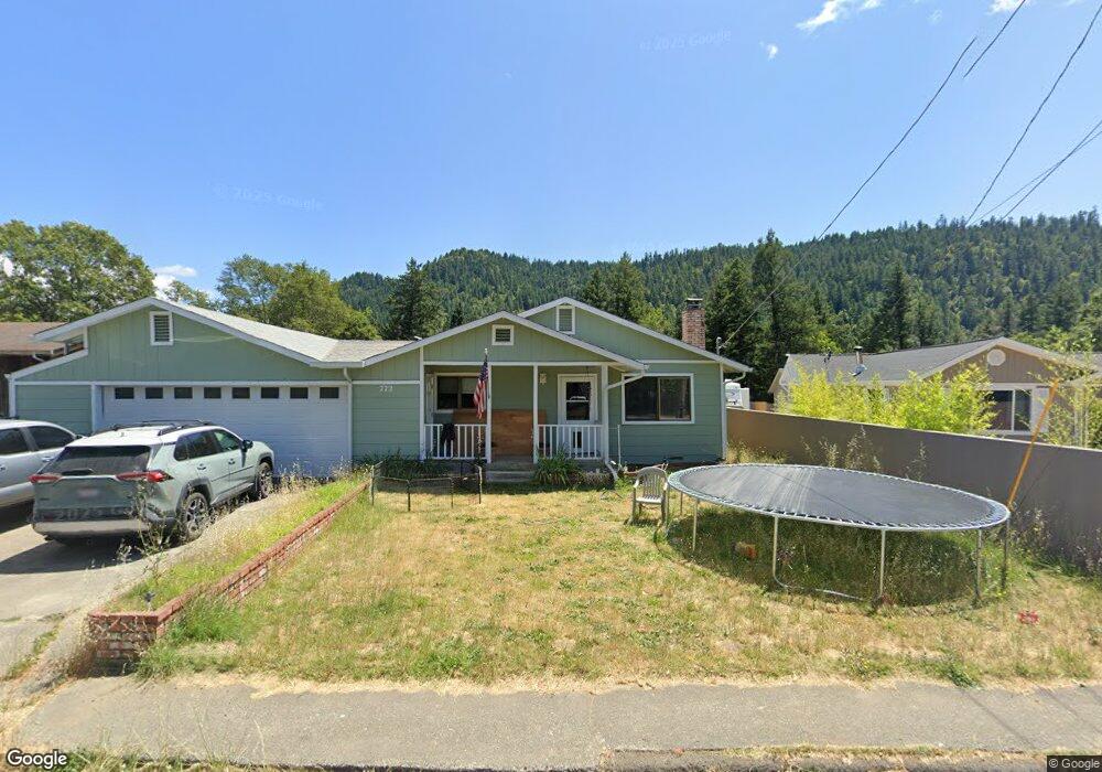
772 Redway Dr Redway, CA 95560
Estimated Value: $345,000 - $447,000
3
Beds
2
Baths
1,800
Sq Ft
$212/Sq Ft
Est. Value
About This Home
This home is located at 772 Redway Dr, Redway, CA 95560 and is currently estimated at $381,637, approximately $212 per square foot. 772 Redway Dr is a home located in Humboldt County.
Ownership History
Date
Name
Owned For
Owner Type
Purchase Details
Closed on
May 9, 2022
Sold by
Albonico and Violet
Bought by
Gary W And Mary H Hand Revocable Trust
Current Estimated Value
Purchase Details
Closed on
Jan 8, 2002
Sold by
Albonico Violet and Albonico Kevin
Bought by
Albonico Kevin and Albonico Violet
Home Financials for this Owner
Home Financials are based on the most recent Mortgage that was taken out on this home.
Original Mortgage
$118,500
Interest Rate
6.84%
Mortgage Type
Purchase Money Mortgage
Purchase Details
Closed on
Jul 14, 1999
Sold by
Zaugg Janice R
Bought by
Byerley Violet Y and Albonico Kevin
Home Financials for this Owner
Home Financials are based on the most recent Mortgage that was taken out on this home.
Original Mortgage
$118,400
Interest Rate
7.64%
Mortgage Type
Purchase Money Mortgage
Create a Home Valuation Report for This Property
The Home Valuation Report is an in-depth analysis detailing your home's value as well as a comparison with similar homes in the area
Home Values in the Area
Average Home Value in this Area
Purchase History
| Date | Buyer | Sale Price | Title Company |
|---|---|---|---|
| Gary W And Mary H Hand Revocable Trust | $350,000 | Humboldt Land Title | |
| Albonico Kevin | -- | Fidelity National Title Co | |
| Byerley Violet Y | $148,000 | Fidelity National Title Co | |
| Zaugg Janice R | -- | Fidelity National Title Co |
Source: Public Records
Mortgage History
| Date | Status | Borrower | Loan Amount |
|---|---|---|---|
| Previous Owner | Albonico Kevin | $118,500 | |
| Previous Owner | Byerley Violet Y | $118,400 |
Source: Public Records
Tax History
| Year | Tax Paid | Tax Assessment Tax Assessment Total Assessment is a certain percentage of the fair market value that is determined by local assessors to be the total taxable value of land and additions on the property. | Land | Improvement |
|---|---|---|---|---|
| 2025 | $3,946 | $371,422 | $137,957 | $233,465 |
| 2024 | $3,946 | $364,140 | $135,252 | $228,888 |
| 2023 | $3,961 | $357,000 | $132,600 | $224,400 |
| 2022 | $2,686 | $239,792 | $65,164 | $174,628 |
| 2021 | $2,584 | $235,091 | $63,887 | $171,204 |
| 2020 | $2,598 | $232,681 | $63,232 | $169,449 |
| 2019 | $2,533 | $228,120 | $61,993 | $166,127 |
| 2018 | $2,489 | $223,648 | $60,778 | $162,870 |
| 2017 | $2,441 | $219,264 | $59,587 | $159,677 |
| 2016 | $2,173 | $192,142 | $58,419 | $133,723 |
| 2015 | -- | $189,257 | $57,542 | $131,715 |
| 2014 | -- | $185,550 | $56,415 | $129,135 |
Source: Public Records
Map
Nearby Homes
- 671 Orchard Ln
- 87 Manzanita Ave
- 416 Birdie Ln
- 478 Redway Dr
- 44 Mckenzie Ln
- 95 Oak Ave
- 75 Empire Ave
- 176 Rusk Ln
- 190 Pine St
- 85 Madrone Ave
- 64 Pacific Ave
- 273 Forest Dr
- 5200 Briceland Rd
- 77 Mill Rd
- 2611 Redwood Dr
- 0 Connick Creek Rd
- 575 Connick Creek Rd
- 1777 Sprowl Creek Rd
- 700 Willow Rd
- 4001 Old Briceland Rd
Your Personal Tour Guide
Ask me questions while you tour the home.