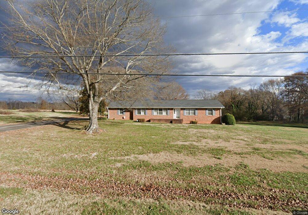
7740 Parris Bridge Rd Chesnee, SC 29323
Estimated Value: $256,000 - $391,000
4
Beds
2
Baths
2,040
Sq Ft
$155/Sq Ft
Est. Value
About This Home
This home is located at 7740 Parris Bridge Rd, Chesnee, SC 29323 and is currently estimated at $315,997, approximately $154 per square foot. 7740 Parris Bridge Rd is a home located in Spartanburg County with nearby schools including Chesnee Elementary School, Chesnee Middle School, and Chesnee High School.
Ownership History
Date
Name
Owned For
Owner Type
Purchase Details
Closed on
Sep 21, 2009
Sold by
Painter Donald E and Painter Donald
Bought by
Painter Donald E and Painter Karen
Current Estimated Value
Purchase Details
Closed on
Sep 18, 2009
Sold by
Painter Carroll and Painter Richard S
Bought by
Painter Donald E and Painter Donald
Purchase Details
Closed on
May 24, 2009
Sold by
Estate Of B Eugene Painter
Bought by
Painter Donald and Painter Carroll
Create a Home Valuation Report for This Property
The Home Valuation Report is an in-depth analysis detailing your home's value as well as a comparison with similar homes in the area
Home Values in the Area
Average Home Value in this Area
Purchase History
| Date | Buyer | Sale Price | Title Company |
|---|---|---|---|
| Painter Donald E | -- | -- | |
| Painter Donald E | -- | -- | |
| Painter Donald E | $100,000 | -- | |
| Painter Donald | -- | -- |
Source: Public Records
Tax History Compared to Growth
Tax History
| Year | Tax Paid | Tax Assessment Tax Assessment Total Assessment is a certain percentage of the fair market value that is determined by local assessors to be the total taxable value of land and additions on the property. | Land | Improvement |
|---|---|---|---|---|
| 2025 | $981 | $8,059 | $848 | $7,211 |
| 2024 | $981 | $8,059 | $848 | $7,211 |
| 2023 | $981 | $8,059 | $848 | $7,211 |
| 2022 | $849 | $7,008 | $680 | $6,328 |
| 2021 | $849 | $7,008 | $680 | $6,328 |
| 2020 | $832 | $7,008 | $680 | $6,328 |
| 2019 | $832 | $7,008 | $680 | $6,328 |
| 2018 | $812 | $7,008 | $680 | $6,328 |
| 2017 | $681 | $6,132 | $652 | $5,480 |
| 2016 | $681 | $6,132 | $652 | $5,480 |
| 2015 | $676 | $6,132 | $652 | $5,480 |
| 2014 | $671 | $6,132 | $652 | $5,480 |
Source: Public Records
Map
Nearby Homes
- 351 Smith Wall Rd
- 0 Cantrell Dr
- 216 Sweetgrass Dr
- 202 Arrowood Branch Rd
- 107 Brooklyn Church Rd
- 140 Manor House Ln
- 190 Clement Rd
- 1543 Highway 11 W
- 291 Robbins Rd
- 561 State Road S-42-1879
- 565 State Road S-42-1879
- 569 State Road S-42-1879
- 545 State Road S-42-1879
- 537 State Road S-42-1879
- 523 State Road S-42-1879
- 0 State Road S-42-1879
- 268 Margate Cir
- 229 Holly Rd
- 447 Henderson Rd
- 402 Dodger Ave
- 7760 Parris Bridge Rd
- 7743 Parris Bridge Rd
- 7720 Parris Bridge Rd
- 7764 Parris Bridge Rd
- 7771 Parris Bridge Rd
- 450 Smith Wall Rd
- 7780 Parris Bridge Rd
- 436 Smith Wall Rd
- 7807 Parris Bridge Rd
- 447 Smith Wall Rd
- 459 Smith Wall Rd
- 7855 Parris Bridge Rd
- 7657 Parris Bridge Rd
- 7617 Parris Bridge Rd
- 7650 Parris Bridge Rd
- 7651 Parris Bridge Rd
- 7885 Parris Bridge Rd
- 396 Smith Wall Rd
- 624 Raytown Dr
- 375 Ivey Rd