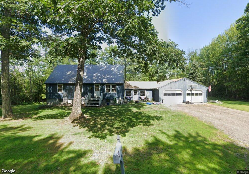
777 Pendexter Rd Parsonsfield, ME 04047
Estimated Value: $330,288 - $392,000
--
Bed
--
Bath
1,224
Sq Ft
$293/Sq Ft
Est. Value
About This Home
This home is located at 777 Pendexter Rd, Parsonsfield, ME 04047 and is currently estimated at $358,322, approximately $292 per square foot. 777 Pendexter Rd is a home with nearby schools including Ossipee Valley Christian School.
Ownership History
Date
Name
Owned For
Owner Type
Purchase Details
Closed on
Sep 1, 2017
Sold by
Harmon David G
Bought by
Gilpatrick Matthew K and Lachance Brittany L
Current Estimated Value
Home Financials for this Owner
Home Financials are based on the most recent Mortgage that was taken out on this home.
Original Mortgage
$146,400
Outstanding Balance
$122,451
Interest Rate
3.96%
Mortgage Type
Commercial
Estimated Equity
$235,871
Purchase Details
Closed on
Apr 13, 2005
Sold by
Powell Donna M
Bought by
Harmon David G
Create a Home Valuation Report for This Property
The Home Valuation Report is an in-depth analysis detailing your home's value as well as a comparison with similar homes in the area
Home Values in the Area
Average Home Value in this Area
Purchase History
| Date | Buyer | Sale Price | Title Company |
|---|---|---|---|
| Gilpatrick Matthew K | -- | -- | |
| Harmon David G | -- | -- |
Source: Public Records
Mortgage History
| Date | Status | Borrower | Loan Amount |
|---|---|---|---|
| Open | Gilpatrick Matthew K | $146,400 |
Source: Public Records
Tax History Compared to Growth
Tax History
| Year | Tax Paid | Tax Assessment Tax Assessment Total Assessment is a certain percentage of the fair market value that is determined by local assessors to be the total taxable value of land and additions on the property. | Land | Improvement |
|---|---|---|---|---|
| 2024 | $2,841 | $169,093 | $50,500 | $118,593 |
| 2023 | $2,739 | $169,093 | $50,500 | $118,593 |
| 2022 | $2,621 | $169,093 | $50,500 | $118,593 |
| 2021 | $2,612 | $169,093 | $50,500 | $118,593 |
| 2020 | $2,562 | $169,093 | $50,500 | $118,593 |
| 2019 | $2,519 | $169,093 | $50,500 | $118,593 |
| 2017 | $2,519 | $169,093 | $50,500 | $118,593 |
| 2016 | $2,519 | $169,093 | $50,500 | $118,593 |
Source: Public Records
Map
Nearby Homes
- Lot #00 North Rd
- Lot# 01 North Rd
- Lot #02 North Rd
- 20 Hollyhock Farm Ln
- 27 Nocturne Rd
- R13/038 Weeks Rd
- 178 Maplecrest Rd
- 424 Maplecrest Rd
- 8 Pennie Ln
- Lot 5 Fenderson Rd
- 9 Penny Ln
- 32 Summer St
- 266 S Hiram Rd
- Lot #5 Jordan Heights Rd
- 42 Pine St
- 35 Pine St
- Lot 1 Moulton Hill Rd
- R3-32 Ossipee Trail
- 87 First County Rd
- 27 Lynn Dr
- 781 Pendexter Rd
- 10 Orchard Rd
- Lot 12 Orchard Rd
- 15 Orchard Rd
- 20 Orchard Rd
- 748 Pendexter Rd
- 865 Pendexter Rd
- 804 Pendexter Rd
- 122 Emery Woods Rd
- 0 Pendexter Rd
- 30 Orchard Rd
- 813 Pendexter Rd
- 722 Pendexter Rd
- 40 Orchard Rd
- 51 Orchard Rd
- 67 Orchard Rd
- 48 Orchard Rd
- 8 Orchard Rd
- 56 Orchard Rd
- 81 Orchard Rd