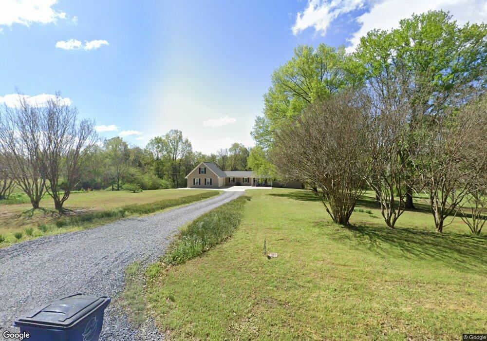
7771 Dunn Ln E Olive Branch, MS 38654
Lewisburg NeighborhoodEstimated Value: $330,465 - $525,000
3
Beds
--
Bath
2,871
Sq Ft
$147/Sq Ft
Est. Value
About This Home
This home is located at 7771 Dunn Ln E, Olive Branch, MS 38654 and is currently estimated at $423,366, approximately $147 per square foot. 7771 Dunn Ln E is a home located in DeSoto County with nearby schools including Lewisburg Primary School, Lewisburg Elementary School, and Lewisburg Middle School.
Ownership History
Date
Name
Owned For
Owner Type
Purchase Details
Closed on
Oct 2, 2024
Sold by
Dunlap William P and Dunlap William Powell
Bought by
Dunlap William Powell and Dunlap Meredith Suzanne
Current Estimated Value
Home Financials for this Owner
Home Financials are based on the most recent Mortgage that was taken out on this home.
Original Mortgage
$50,000
Outstanding Balance
$49,326
Interest Rate
6.35%
Mortgage Type
New Conventional
Estimated Equity
$374,040
Purchase Details
Closed on
Nov 9, 2018
Sold by
Dunlap William M
Bought by
Dunlap William P
Create a Home Valuation Report for This Property
The Home Valuation Report is an in-depth analysis detailing your home's value as well as a comparison with similar homes in the area
Home Values in the Area
Average Home Value in this Area
Purchase History
| Date | Buyer | Sale Price | Title Company |
|---|---|---|---|
| Dunlap William Powell | -- | Servicelink | |
| Dunlap William Powell | -- | Servicelink | |
| Dunlap William P | -- | None Available |
Source: Public Records
Mortgage History
| Date | Status | Borrower | Loan Amount |
|---|---|---|---|
| Open | Dunlap William Powell | $50,000 | |
| Closed | Dunlap William Powell | $50,000 |
Source: Public Records
Tax History
| Year | Tax Paid | Tax Assessment Tax Assessment Total Assessment is a certain percentage of the fair market value that is determined by local assessors to be the total taxable value of land and additions on the property. | Land | Improvement |
|---|---|---|---|---|
| 2025 | $2,160 | $21,239 | $3,338 | $17,901 |
| 2024 | $1,866 | $15,868 | $3,341 | $12,527 |
| 2023 | $1,866 | $15,614 | $0 | $0 |
| 2022 | $1,019 | $9,596 | $4,048 | $5,548 |
| 2021 | $1,325 | $9,640 | $4,092 | $5,548 |
| 2020 | $933 | $9,241 | $4,137 | $5,104 |
| 2019 | $929 | $9,197 | $4,093 | $5,104 |
| 2017 | $262 | $15,259 | $10,073 | $5,186 |
| 2016 | $249 | $9,838 | $4,652 | $5,186 |
| 2015 | $1,001 | $15,024 | $9,838 | $5,186 |
| 2014 | $227 | $9,733 | $0 | $0 |
| 2013 | $213 | $9,640 | $0 | $0 |
Source: Public Records
Map
Nearby Homes
- 8433 Lakeview Dr
- 3847 Woodcrest Dr
- 5291 Borden Creek Dr
- 5293 Borden Creek Dr
- 2466 Ross Rd
- 8465 Belmor Lakes Dr
- 8052 Christian Ct
- 7672 Rigmoore Point N
- 7684 Rigmoore Point N
- 4113 Georgia Place
- 4117 Georgia Place
- 8055 Old Addison Dr
- 8070 Old Addison Dr
- 8066 Old Addison Dr
- 8026 Old Addison Dr
- 8058 Old Addison Dr
- 8046 Old Addison Dr
- 8054 Old Addison Dr
- 4114 Dawkins Farm Dr
- 8122 Bella Donna Cir
Your Personal Tour Guide
Ask me questions while you tour the home.