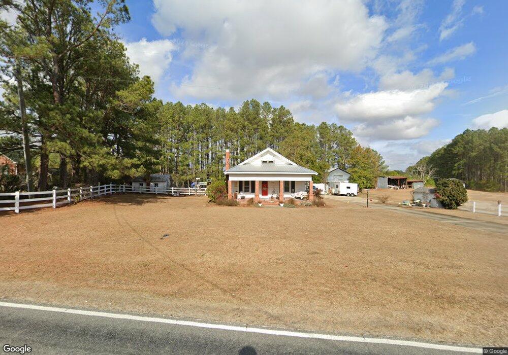
778 Massengill Pond Rd Angier, NC 27501
Pleasant Grove NeighborhoodEstimated Value: $291,000 - $353,003
3
Beds
2
Baths
1,439
Sq Ft
$216/Sq Ft
Est. Value
About This Home
This home is located at 778 Massengill Pond Rd, Angier, NC 27501 and is currently estimated at $311,001, approximately $216 per square foot. 778 Massengill Pond Rd is a home located in Johnston County with nearby schools including Benson Elementary School, Benson Middle School, and West Johnston High School.
Ownership History
Date
Name
Owned For
Owner Type
Purchase Details
Closed on
Jul 26, 2010
Sold by
Stephenson James W and Stephenson Kathy Jackson
Bought by
Holder William W
Current Estimated Value
Home Financials for this Owner
Home Financials are based on the most recent Mortgage that was taken out on this home.
Original Mortgage
$128,272
Outstanding Balance
$85,696
Interest Rate
4.75%
Mortgage Type
FHA
Estimated Equity
$225,305
Create a Home Valuation Report for This Property
The Home Valuation Report is an in-depth analysis detailing your home's value as well as a comparison with similar homes in the area
Home Values in the Area
Average Home Value in this Area
Purchase History
| Date | Buyer | Sale Price | Title Company |
|---|---|---|---|
| Holder William W | $130,000 | None Available |
Source: Public Records
Mortgage History
| Date | Status | Borrower | Loan Amount |
|---|---|---|---|
| Open | Holder William W | $128,272 |
Source: Public Records
Tax History Compared to Growth
Tax History
| Year | Tax Paid | Tax Assessment Tax Assessment Total Assessment is a certain percentage of the fair market value that is determined by local assessors to be the total taxable value of land and additions on the property. | Land | Improvement |
|---|---|---|---|---|
| 2025 | $1,870 | $276,480 | $106,510 | $169,970 |
| 2024 | $1,395 | $172,180 | $50,590 | $121,590 |
| 2023 | $1,343 | $172,180 | $50,590 | $121,590 |
| 2022 | $1,412 | $172,180 | $50,590 | $121,590 |
| 2021 | $1,377 | $172,180 | $50,590 | $121,590 |
| 2020 | $1,429 | $172,180 | $50,590 | $121,590 |
| 2019 | $1,419 | $170,980 | $50,590 | $120,390 |
| 2018 | $0 | $135,340 | $39,940 | $95,400 |
| 2017 | $1,150 | $135,340 | $39,940 | $95,400 |
| 2016 | $1,150 | $135,340 | $39,940 | $95,400 |
| 2015 | $1,150 | $135,340 | $39,940 | $95,400 |
| 2014 | $1,150 | $135,340 | $39,940 | $95,400 |
Source: Public Records
Map
Nearby Homes
- 81 Pinon Dr
- 46 Two Belles Ct
- 0 Massengill Pond Rd
- 120 Massengill Pond Rd
- 5750 Old Fairground Rd
- 130 Holland Rd
- Stanley Plan at Black Forest Pointe
- Wilmington Plan at Black Forest Pointe
- Avery Plan at Black Forest Pointe
- Cypress Plan at Black Forest Pointe
- Oxford Plan at Black Forest Pointe
- Ellerbe Plan at Black Forest Pointe
- Raleigh Plan at Black Forest Pointe
- Cypress Plan at Cedar Ridge
- Wescott Plan at Cedar Ridge
- Colfax Plan at Cedar Ridge
- Edgefield Plan at Cedar Ridge
- Cooper Plan at Cedar Ridge
- Hamilton Plan at Cedar Ridge
- Davidson Plan at Cedar Ridge
- 778 Massengill Pond Rd
- 780 Massengill Pond Rd
- 785 Massengill Pond Rd
- 775 Massengill Pond Rd
- 836 Massengill Pond Rd
- 765 Massengill Pond Rd
- 77 Ridge Rd
- 755 Massengill Pond Rd
- 733 Massengill Pond Rd
- 101 Ridge Rd
- 727 Massengill Pond Rd
- 100 Pleasant Pine Dr
- 101 10th Ave
- 641 Massengill Pond Rd
- 129 Pleasant Pine Dr
- 126 Ridge Rd
- 101 Pleasant Pine Dr
- 125 Pleasant Pine Dr
- 109 Wilbur Ln
- 101 Wilbur Ln