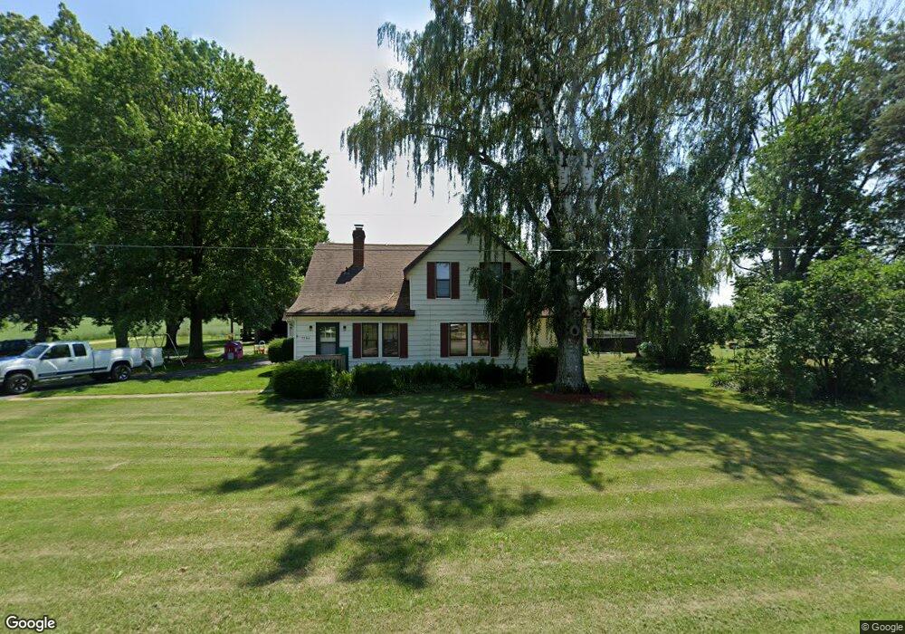
7790 N Branch Rd Watervliet, MI 49098
Estimated Value: $271,000 - $375,000
5
Beds
3
Baths
2,400
Sq Ft
$140/Sq Ft
Est. Value
About This Home
This home is located at 7790 N Branch Rd, Watervliet, MI 49098 and is currently estimated at $337,123, approximately $140 per square foot. 7790 N Branch Rd is a home located in Berrien County with nearby schools including South Elementary School, North Elementary School, and Watervliet Middle School.
Ownership History
Date
Name
Owned For
Owner Type
Purchase Details
Closed on
May 17, 2007
Sold by
Leverton Alvin M and Leverton Patricia A
Bought by
Wells Fargo Bank Na and Asset Backed Pass Through Certificate Se
Current Estimated Value
Purchase Details
Closed on
Nov 17, 1997
Purchase Details
Closed on
Oct 2, 1990
Create a Home Valuation Report for This Property
The Home Valuation Report is an in-depth analysis detailing your home's value as well as a comparison with similar homes in the area
Home Values in the Area
Average Home Value in this Area
Purchase History
| Date | Buyer | Sale Price | Title Company |
|---|---|---|---|
| Wells Fargo Bank Na | $178,455 | None Available | |
| -- | $122,000 | -- | |
| -- | -- | -- |
Source: Public Records
Tax History Compared to Growth
Tax History
| Year | Tax Paid | Tax Assessment Tax Assessment Total Assessment is a certain percentage of the fair market value that is determined by local assessors to be the total taxable value of land and additions on the property. | Land | Improvement |
|---|---|---|---|---|
| 2025 | $2,602 | $162,700 | $0 | $0 |
| 2024 | $2,085 | $151,000 | $0 | $0 |
| 2023 | $1,986 | $134,600 | $0 | $0 |
| 2022 | $1,943 | $121,100 | $0 | $0 |
| 2021 | $2,320 | $111,400 | $5,000 | $106,400 |
| 2020 | $2,289 | $105,000 | $0 | $0 |
| 2019 | $2,246 | $92,800 | $7,900 | $84,900 |
| 2018 | $2,193 | $92,800 | $0 | $0 |
| 2017 | $2,269 | $95,400 | $0 | $0 |
| 2016 | $2,211 | $94,700 | $0 | $0 |
| 2015 | $2,302 | $101,700 | $0 | $0 |
| 2014 | $1,817 | $98,100 | $0 | $0 |
Source: Public Records
Map
Nearby Homes
- 1980 Angling Rd
- 1955 Angling Rd
- 0 Highway M-140
- 6660 Pine Rd
- 6808 Territorial Rd
- 8552 Dan Smith Rd
- 2611 Friday Rd
- VL S Arent Rd
- 1370 N Park Rd
- VL S Bainbridge Center Rd
- VL Territorial Rd Unit Lot B1
- VL Territorial Rd Unit Lot B2
- VL Territorial Rd Unit Lot C4
- VL Territorial Rd Unit Lot C3
- VL Territorial Rd Unit Lot C2
- VL Territorial Rd Unit Lot C1
- VL Territorial Rd Unit Lot B5
- VL Territorial Rd Unit Lot B4
- VL Territorial Rd Unit Lot B3
- VL Territorial Rd Unit A3
- 7809 N Branch Rd
- 7839 Northbranch Rd
- 7775 N Branch Rd
- 7860 Northbranch Rd
- 7640 Northbranch Rd
- 7929 N Branch Rd
- 8110 Northbranch Rd
- 8110 Northbranch Rd
- 8040 Northbranch Rd
- 7520 N Branch Rd
- 7515 Northbranch Rd
- 7995 N Branch Rd
- 6875 N Branch Rd
- 0 N Branch Rd
- VL Highway M-140
- 8119 N Branch Rd
- 7680 Hill Rd
- 7780 Hill Rd
- 1179 N M 140
- 1179 Highway M-140