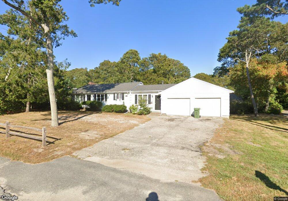
78 Pitchers Way Hyannis, MA 02601
Estimated Value: $607,000 - $622,000
3
Beds
2
Baths
1,694
Sq Ft
$363/Sq Ft
Est. Value
About This Home
This home is located at 78 Pitchers Way, Hyannis, MA 02601 and is currently estimated at $614,080, approximately $362 per square foot. 78 Pitchers Way is a home located in Barnstable County with nearby schools including Hyannis West Elementary School, Barnstable United Elementary School, and Barnstable Intermediate School.
Ownership History
Date
Name
Owned For
Owner Type
Purchase Details
Closed on
Feb 15, 2006
Sold by
Marlene S Hahn Nt
Bought by
Dewey Jacob T
Current Estimated Value
Home Financials for this Owner
Home Financials are based on the most recent Mortgage that was taken out on this home.
Original Mortgage
$240,000
Outstanding Balance
$135,350
Interest Rate
6.23%
Mortgage Type
Purchase Money Mortgage
Estimated Equity
$478,730
Create a Home Valuation Report for This Property
The Home Valuation Report is an in-depth analysis detailing your home's value as well as a comparison with similar homes in the area
Home Values in the Area
Average Home Value in this Area
Purchase History
| Date | Buyer | Sale Price | Title Company |
|---|---|---|---|
| Dewey Jacob T | $300,000 | -- |
Source: Public Records
Mortgage History
| Date | Status | Borrower | Loan Amount |
|---|---|---|---|
| Open | Dewey Jacob T | $240,000 | |
| Closed | Dewey Jacob T | $30,000 |
Source: Public Records
Tax History Compared to Growth
Tax History
| Year | Tax Paid | Tax Assessment Tax Assessment Total Assessment is a certain percentage of the fair market value that is determined by local assessors to be the total taxable value of land and additions on the property. | Land | Improvement |
|---|---|---|---|---|
| 2025 | $4,288 | $462,600 | $149,600 | $313,000 |
| 2024 | $4,165 | $460,200 | $149,600 | $310,600 |
| 2023 | $3,902 | $407,700 | $136,000 | $271,700 |
| 2022 | $3,905 | $337,500 | $100,800 | $236,700 |
| 2021 | $3,524 | $295,900 | $100,800 | $195,100 |
| 2020 | $3,528 | $286,100 | $100,800 | $185,300 |
| 2019 | $3,363 | $267,300 | $100,800 | $166,500 |
| 2018 | $3,036 | $246,800 | $106,100 | $140,700 |
| 2017 | $2,882 | $240,400 | $106,100 | $134,300 |
| 2016 | $2,828 | $241,100 | $106,800 | $134,300 |
| 2015 | $2,765 | $239,000 | $102,800 | $136,200 |
Source: Public Records
Map
Nearby Homes
- 135 W Main St Unit 45
- 50 Redwood Ln
- 14 Marston Ave
- 15 Goldie Way
- 297 W Main St Unit 12
- 229 Greenwood Ave
- 24 Bettys Pond Rd Unit K
- 24 Betty's Pond Rd Unit 1K
- 417 Scudder Ave
- 427 Scudder Ave
- 20 Sunset Terrace
- 36 Grouse Ln
- 93 Sea St
- 35 Grayton Ave
- 292 Megan Rd
- 83 Peacock Dr
- 18 Mount Vernon Ave
- 141 Dolphin Ln
- 295 Sudbury Ln
- 342 Sea St
- 68 Pitchers Way
- 0 Pitchers Way
- 25 Portside Dr
- 74 Pitchers Way
- 92 Pitchers Way
- 81 Pitchers Way
- 64 Pitchers Way
- 116 Frost Ln
- 65 Pitchers Way
- 65 Pitcher's Way
- 15 Portside Dr
- 104 Pitchers Way
- 20 Portside Dr
- 52 Pitchers Way
- 107 Pitchers Way
- 106 Frost Ln
- 5 Sylvan Dr
- 17 Sylvan Dr
- 204 Scudder Ave
- 44 Pitchers Way