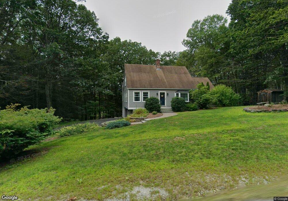
78 Proctor Rd Wilton, NH 03086
Estimated Value: $480,000 - $606,000
3
Beds
3
Baths
2,383
Sq Ft
$237/Sq Ft
Est. Value
About This Home
This home is located at 78 Proctor Rd, Wilton, NH 03086 and is currently estimated at $563,967, approximately $236 per square foot. 78 Proctor Rd is a home located in Hillsborough County with nearby schools including Florence Rideout Elementary School, Wilton-Lyndeborough Cooperative Middle School, and Wilton-Lyndeborough Cooperative High School.
Ownership History
Date
Name
Owned For
Owner Type
Purchase Details
Closed on
Nov 10, 2022
Sold by
Bosquet Cheryl L
Bought by
Clb Ret
Current Estimated Value
Purchase Details
Closed on
Oct 1, 1991
Bought by
Bosquet Cheryl L
Create a Home Valuation Report for This Property
The Home Valuation Report is an in-depth analysis detailing your home's value as well as a comparison with similar homes in the area
Home Values in the Area
Average Home Value in this Area
Purchase History
| Date | Buyer | Sale Price | Title Company |
|---|---|---|---|
| Clb Ret | -- | None Available | |
| Bosquet Cheryl L | -- | -- |
Source: Public Records
Mortgage History
| Date | Status | Borrower | Loan Amount |
|---|---|---|---|
| Previous Owner | Bosquet Cheryl L | $48,900 | |
| Previous Owner | Bosquet Cheryl L | $59,276 |
Source: Public Records
Tax History
| Year | Tax Paid | Tax Assessment Tax Assessment Total Assessment is a certain percentage of the fair market value that is determined by local assessors to be the total taxable value of land and additions on the property. | Land | Improvement |
|---|---|---|---|---|
| 2025 | $10,994 | $407,500 | $122,400 | $285,100 |
| 2024 | $10,135 | $407,500 | $122,400 | $285,100 |
| 2023 | $9,047 | $407,500 | $122,400 | $285,100 |
| 2022 | $8,419 | $407,500 | $122,400 | $285,100 |
| 2021 | $7,746 | $403,000 | $122,400 | $280,600 |
| 2020 | $8,423 | $286,600 | $86,600 | $200,000 |
| 2019 | $8,323 | $286,600 | $86,600 | $200,000 |
| 2018 | $8,243 | $286,600 | $86,600 | $200,000 |
| 2017 | $7,787 | $286,600 | $86,600 | $200,000 |
| 2016 | $7,549 | $286,600 | $86,600 | $200,000 |
| 2015 | $7,620 | $289,300 | $103,000 | $186,300 |
| 2014 | $7,464 | $289,300 | $103,000 | $186,300 |
| 2013 | $7,587 | $291,600 | $103,000 | $188,600 |
Source: Public Records
Map
Nearby Homes
- 85 Intervale Rd
- 124 Abbot Hill Rd
- F88-9 McGettigan Rd
- F/88-5 McGettigan Rd
- F/88-4 McGettigan Rd
- 25 Burns Hill Rd
- 10 Whiting Hill Rd
- F-88-11 Aria Hill Dr
- F-88-12 Aria Hill Dr
- F-88-7 Aria Hill Dr
- 589 Gibbons Hwy
- 143 Falcon Ridge Rd Unit 23
- F88-10 McGettigan Rd
- Lots 4 & 7 Gibbons & Robbins Rd
- 33 Falcon Ridge Rd Unit 33
- 0 Captain Clark Hwy
- 16 Cortland Rd
- 58-6-2 Duggin Rd
- 545 Elm St Unit 4
- A 66 Burton Hwy
Your Personal Tour Guide
Ask me questions while you tour the home.