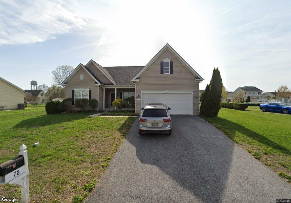
78 Quail Landing Cir Magnolia, DE 19962
Rising Sun-Lebanon NeighborhoodEstimated Value: $417,000 - $474,667
3
Beds
2
Baths
1,903
Sq Ft
$237/Sq Ft
Est. Value
About This Home
This home is located at 78 Quail Landing Cir, Magnolia, DE 19962 and is currently estimated at $450,667, approximately $236 per square foot. 78 Quail Landing Cir is a home located in Kent County with nearby schools including Allen Frear Elementary School, F. Niel Postlethwait Middle School, and Caesar Rodney High School.
Ownership History
Date
Name
Owned For
Owner Type
Purchase Details
Closed on
Oct 30, 2015
Sold by
Timberlake Riverside Llc
Bought by
Swayne Gail
Current Estimated Value
Home Financials for this Owner
Home Financials are based on the most recent Mortgage that was taken out on this home.
Original Mortgage
$255,919
Outstanding Balance
$201,906
Interest Rate
3.88%
Mortgage Type
FHA
Estimated Equity
$248,761
Purchase Details
Closed on
Nov 11, 2013
Sold by
Santone Enterprises Llc
Bought by
Timberlake Riverside Llc
Home Financials for this Owner
Home Financials are based on the most recent Mortgage that was taken out on this home.
Original Mortgage
$4,000,000
Interest Rate
4.17%
Mortgage Type
Commercial
Create a Home Valuation Report for This Property
The Home Valuation Report is an in-depth analysis detailing your home's value as well as a comparison with similar homes in the area
Home Values in the Area
Average Home Value in this Area
Purchase History
| Date | Buyer | Sale Price | Title Company |
|---|---|---|---|
| Swayne Gail | $279,465 | None Available | |
| Timberlake Riverside Llc | $65,000 | None Available |
Source: Public Records
Mortgage History
| Date | Status | Borrower | Loan Amount |
|---|---|---|---|
| Open | Swayne Gail | $255,919 | |
| Previous Owner | Timberlake Riverside Llc | $4,000,000 |
Source: Public Records
Tax History Compared to Growth
Tax History
| Year | Tax Paid | Tax Assessment Tax Assessment Total Assessment is a certain percentage of the fair market value that is determined by local assessors to be the total taxable value of land and additions on the property. | Land | Improvement |
|---|---|---|---|---|
| 2025 | $1,907 | $464,200 | $89,300 | $374,900 |
| 2024 | $1,907 | $464,200 | $89,300 | $374,900 |
| 2023 | $2,147 | $64,400 | $5,600 | $58,800 |
| 2022 | $2,022 | $64,400 | $5,600 | $58,800 |
| 2021 | $2,144 | $64,400 | $5,600 | $58,800 |
| 2020 | $1,788 | $58,400 | $5,600 | $52,800 |
| 2019 | $1,726 | $58,400 | $5,600 | $52,800 |
| 2018 | $1,679 | $58,400 | $5,600 | $52,800 |
| 2017 | $1,647 | $58,400 | $0 | $0 |
| 2016 | $1,677 | $58,400 | $0 | $0 |
| 2015 | $986 | $52,500 | $0 | $0 |
| 2014 | $1,006 | $52,500 | $0 | $0 |
Source: Public Records
Map
Nearby Homes
- 580 Locust Grove Rd
- 38 Planters Run Ct
- 3444 S State St
- 128 Jillian Ct
- 326 Remington Dr
- 1810 Windswept Cir
- 83 Homestead Dr
- 279 Remington Dr
- 284 Remington Dr
- 573 W Birdie Ln
- 265 Remington Dr
- 270 Remington Dr
- 253 Remington Dr
- 5 Crossley Dr
- 239 Remington Dr
- 139 Chase St
- 124 Carriage Blvd
- 113 Carriage Blvd
- 2043 Highland Ave
- 138 Cilento Dr
- 78 Quail Landing Cir Unit WARWIC
- 38 Trapper Ln
- 58 Trapper Ln
- 60 Trapper Ln
- 98 Quail Landing Cir
- 70 Quail Landing Cir
- 60 Quail Landing Cir
- 72 Trapper Ln
- 64 Quail Landing Cir
- 70 Trapper Ln
- 126 Quail Landing Cir
- 8 Quail Landing Cir
- 10 Quail Landing Cir
- 12 Quail Landing Cir
- 2 Quail Landing Cir
- 6 Quail Landing Cir
- 48 Quail Landing Cir
- 16 Quail Landing Cir
- 18 Quail Landing Cir
- 20 Quail Landing Cir