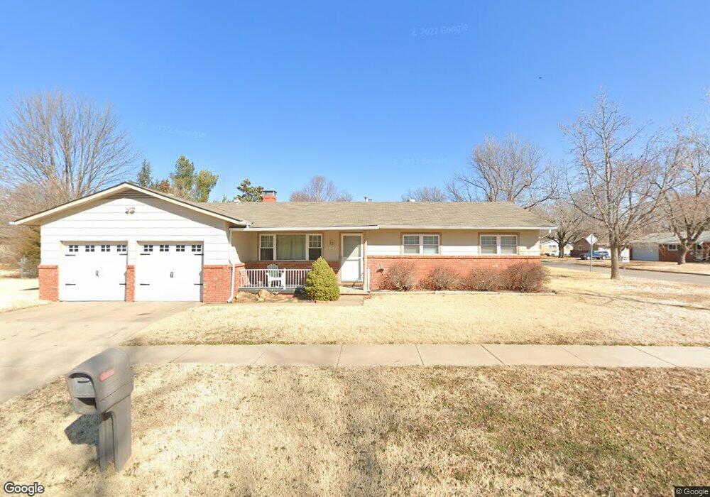
7802 W 10th St N Wichita, KS 67212
West Wichita NeighborhoodEstimated Value: $196,731 - $211,000
3
Beds
2
Baths
1,307
Sq Ft
$156/Sq Ft
Est. Value
About This Home
This home is located at 7802 W 10th St N, Wichita, KS 67212 and is currently estimated at $203,866, approximately $155 per square foot. 7802 W 10th St N is a home located in Sedgwick County with nearby schools including Kensler Elementary School, Wilbur Middle School, and Wichita Northwest High School.
Ownership History
Date
Name
Owned For
Owner Type
Purchase Details
Closed on
Nov 23, 2009
Sold by
Secretary Of Housing & Urban Development
Bought by
Gatley Greg
Current Estimated Value
Purchase Details
Closed on
Jun 11, 2009
Sold by
Messecar Mitch L and Messecar Amanda C
Bought by
Secretary Of Housing & Urban Development
Purchase Details
Closed on
Nov 30, 2005
Sold by
Kuntz Raymond J and Kuntz Tera R
Bought by
Pappas Janet
Create a Home Valuation Report for This Property
The Home Valuation Report is an in-depth analysis detailing your home's value as well as a comparison with similar homes in the area
Home Values in the Area
Average Home Value in this Area
Purchase History
| Date | Buyer | Sale Price | Title Company |
|---|---|---|---|
| Gatley Greg | -- | Sec 1St | |
| Secretary Of Housing & Urban Development | $113,253 | None Available | |
| Pappas Janet | -- | None Available |
Source: Public Records
Tax History Compared to Growth
Tax History
| Year | Tax Paid | Tax Assessment Tax Assessment Total Assessment is a certain percentage of the fair market value that is determined by local assessors to be the total taxable value of land and additions on the property. | Land | Improvement |
|---|---|---|---|---|
| 2025 | $1,649 | $17,469 | $4,474 | $12,995 |
| 2023 | $1,649 | $15,882 | $2,921 | $12,961 |
| 2022 | $1,639 | $14,962 | $2,760 | $12,202 |
| 2021 | $1,586 | $13,984 | $2,760 | $11,224 |
| 2020 | $1,500 | $13,191 | $2,760 | $10,431 |
| 2019 | $1,428 | $12,558 | $2,760 | $9,798 |
| 2018 | $1,389 | $12,190 | $2,070 | $10,120 |
| 2017 | $1,321 | $0 | $0 | $0 |
| 2016 | $1,230 | $0 | $0 | $0 |
| 2015 | -- | $0 | $0 | $0 |
| 2014 | -- | $0 | $0 | $0 |
Source: Public Records
Map
Nearby Homes
- 1140 N Country Acres Ave
- 960 N Denmark Ave
- 980 N Brownthrush Ln
- 949 N Country Acres Ave
- 934 N Denmark Ave
- 7410 W Dorsey Ave
- 1336 N Denmark Ave
- 1308 N Brunswick St
- 7037 W School St
- 7400 W Hale St
- 8421 W Murdock St
- 7421 W Hale Ave
- 1120 N Hazelwood Ln
- 1235 N Mulberry Place
- 967 N Robin Rd
- 7811 W Suncrest Ave
- 1553 N Brunswick St
- 8930 W Suncrest St
- 8117 W Aberdeen St
- 8608 W Nantucket St
- 1107 N Emerson Ave
- 7810 W 10th St N
- 1049 N Emerson Ave
- 1115 N Emerson Ave
- 1108 N Denmark Ave
- 1050 N Denmark Ave
- 1100 N Emerson Ave
- 1108 N Emerson Ave
- 1116 N Denmark Ave
- 1050 N Emerson Ave
- 1041 N Emerson Ave
- 1123 N Emerson Ave
- 1116 N Emerson Ave
- 1042 N Denmark Ave
- 1124 N Denmark Ave
- 1107 N Denmark Ave
- 1042 N Emerson Ave
- 7902 W 10th St N
- 1037 N Emerson Ave
- 1049 N Denmark Ave