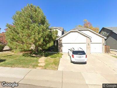
7805 Aravon Ct Lone Tree, CO 80124
Estimated Value: $859,000 - $970,000
4
Beds
3
Baths
2,871
Sq Ft
$314/Sq Ft
Est. Value
About This Home
This home is located at 7805 Aravon Ct, Lone Tree, CO 80124 and is currently estimated at $901,285, approximately $313 per square foot. 7805 Aravon Ct is a home located in Douglas County with nearby schools including Acres Green Elementary School, Cresthill Middle School, and Highlands Ranch High School.
Ownership History
Date
Name
Owned For
Owner Type
Purchase Details
Closed on
Feb 6, 1998
Sold by
U S Home Corp
Bought by
Sharp David Ross and Sharp Vicki Jean
Current Estimated Value
Home Financials for this Owner
Home Financials are based on the most recent Mortgage that was taken out on this home.
Original Mortgage
$200,700
Interest Rate
6.98%
Create a Home Valuation Report for This Property
The Home Valuation Report is an in-depth analysis detailing your home's value as well as a comparison with similar homes in the area
Home Values in the Area
Average Home Value in this Area
Purchase History
| Date | Buyer | Sale Price | Title Company |
|---|---|---|---|
| Sharp David Ross | $250,931 | Heritage Title |
Source: Public Records
Mortgage History
| Date | Status | Borrower | Loan Amount |
|---|---|---|---|
| Open | Sharp David Ross | $669,000 | |
| Closed | Sharp David Ross | $462,555 | |
| Closed | Sharp David Ross | $181,834 | |
| Closed | Sharp David Ross | $190,251 | |
| Closed | Sharp David Ross | $200,700 |
Source: Public Records
Tax History Compared to Growth
Tax History
| Year | Tax Paid | Tax Assessment Tax Assessment Total Assessment is a certain percentage of the fair market value that is determined by local assessors to be the total taxable value of land and additions on the property. | Land | Improvement |
|---|---|---|---|---|
| 2024 | $4,424 | $57,620 | $11,350 | $46,270 |
| 2023 | $4,468 | $57,620 | $11,350 | $46,270 |
| 2022 | $3,260 | $42,810 | $7,680 | $35,130 |
| 2021 | $3,709 | $42,810 | $7,680 | $35,130 |
| 2020 | $3,244 | $42,300 | $7,460 | $34,840 |
| 2019 | $3,254 | $42,300 | $7,460 | $34,840 |
| 2018 | $2,571 | $36,900 | $6,480 | $30,420 |
| 2017 | $2,612 | $36,900 | $6,480 | $30,420 |
| 2016 | $2,712 | $38,180 | $6,740 | $31,440 |
| 2015 | $2,772 | $38,180 | $6,740 | $31,440 |
| 2014 | $2,307 | $31,540 | $6,530 | $25,010 |
Source: Public Records
Map
Nearby Homes
- 7837 Aravon Ct
- 7659 Lebrun Ct
- 10032 Astoria Ct
- 10364 Carriage Club Dr
- 7925 Trotter Ln
- 10383 Erin Place
- 10441 Carriage Club Dr
- 9829 Cypress Point Cir
- 10456 Carriage Club Dr
- 9983 Cottoncreek Dr
- 10529 Dacre Place
- 9873 Greensview Cir
- 9878 Cypress Point Cir
- 7067 Gray Fox Ct
- 9875 Greensview Cir
- 10531 Lieter Place
- 7083 Leopard Dr
- 10213 Bluffmont Dr
- 10127 Bluffmont Ln
- 10103 Bluffmont Ln
- 7805 Aravon Ct
- 7819 Aravon Ct
- 7810 Barkway Ct
- 7824 Barkway Ct
- 10201 Dunsford Dr
- 7796 Barkway Ct
- 7820 Aravon Ct
- 10209 Dunsford Dr
- 7838 Barkway Ct
- 7851 Aravon Ct
- 7838 Aravon Ct
- 7782 Barkway Ct
- 10208 Dunsford Dr
- 10215 Carriage Club Dr
- 10215 Dunsford Dr
- 7835 Barkway Ct
- 7854 Aravon Ct
- 7865 Aravon Ct
- 7852 Barkway Ct
- 7807 Arundel Ln