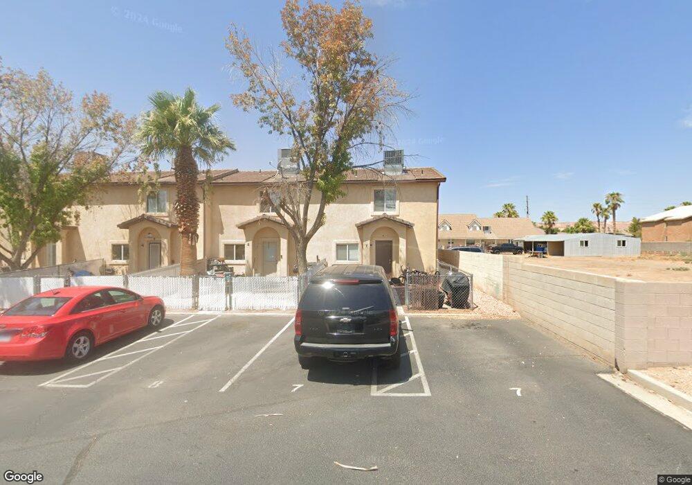
783 Moss Dr Unit 2 Mesquite, NV 89027
Estimated Value: $129,000 - $227,000
2
Beds
2
Baths
1,000
Sq Ft
$188/Sq Ft
Est. Value
About This Home
This home is located at 783 Moss Dr Unit 2, Mesquite, NV 89027 and is currently estimated at $188,475, approximately $188 per square foot. 783 Moss Dr Unit 2 is a home located in Clark County with nearby schools including Virgin Valley Elementary School, Charles Arthur Hughes Middle School, and Virgin Valley High School.
Ownership History
Date
Name
Owned For
Owner Type
Purchase Details
Closed on
Apr 25, 2019
Sold by
Bame Milo T
Bought by
Jennifer Combs Revocable Trust
Current Estimated Value
Purchase Details
Closed on
Sep 20, 2018
Sold by
Maines Theodora J and Maines Teddy J
Bought by
Bame Milo T
Purchase Details
Closed on
May 16, 2018
Sold by
Maines Theodora J
Bought by
Maines Theodora J and Maines Teddy J
Purchase Details
Closed on
Nov 5, 2015
Sold by
Rael Leo J and Rael Frnestine
Bought by
Leo And Tina Real Family Trust Dated Nov
Purchase Details
Closed on
May 11, 2012
Sold by
Noor Razi
Bought by
Rael Leo J and Rael Ernestine
Purchase Details
Closed on
Sep 28, 2011
Sold by
G8 Opportunity Fund Vii Llc
Bought by
Noor Razi
Purchase Details
Closed on
Aug 19, 2011
Sold by
Federal National Mortgage Association
Bought by
G8 Opportunity Fund Vii
Purchase Details
Closed on
Apr 5, 2011
Sold by
Phelps Michael L
Bought by
Federal National Mortgage Association
Purchase Details
Closed on
Mar 26, 2007
Sold by
Mcdonald Roger S
Bought by
Phelps Michael L
Home Financials for this Owner
Home Financials are based on the most recent Mortgage that was taken out on this home.
Original Mortgage
$121,500
Interest Rate
6.11%
Mortgage Type
Unknown
Purchase Details
Closed on
Sep 28, 2006
Sold by
Mcdonald Cathy
Bought by
Mcdonald Roger S
Home Financials for this Owner
Home Financials are based on the most recent Mortgage that was taken out on this home.
Original Mortgage
$106,200
Interest Rate
6.53%
Mortgage Type
Unknown
Purchase Details
Closed on
Aug 21, 2006
Sold by
Bowler Joseph L
Bought by
Mcdonald Roger S
Home Financials for this Owner
Home Financials are based on the most recent Mortgage that was taken out on this home.
Original Mortgage
$106,200
Interest Rate
6.53%
Mortgage Type
Unknown
Create a Home Valuation Report for This Property
The Home Valuation Report is an in-depth analysis detailing your home's value as well as a comparison with similar homes in the area
Home Values in the Area
Average Home Value in this Area
Purchase History
| Date | Buyer | Sale Price | Title Company |
|---|---|---|---|
| Jennifer Combs Revocable Trust | $69,900 | Fidelity National Title M | |
| Bame Milo T | -- | Fidelity National Title M | |
| Bame Milo T | $56,414 | None Available | |
| Maines Theodora J | -- | None Available | |
| Leo And Tina Real Family Trust Dated Nov | -- | None Available | |
| Rael Leo J | $35,000 | Fidelity Title Mesquite | |
| Noor Razi | -- | Fidelity Title Mesquite | |
| Noor Razi | $21,000 | Lawyers Title Of Nevada Cha | |
| G8 Opportunity Fund Vii | $14,022 | Fnf Service Link | |
| Federal National Mortgage Association | $112,928 | Pasion Title Services | |
| Phelps Michael L | $135,000 | Equity Title Of Nevada | |
| Mcdonald Roger S | -- | Equity Title Of Nevada | |
| Mcdonald Roger S | $106,200 | Equity Title Of Nevada |
Source: Public Records
Mortgage History
| Date | Status | Borrower | Loan Amount |
|---|---|---|---|
| Previous Owner | Phelps Michael L | $121,500 | |
| Previous Owner | Mcdonald Roger S | $106,200 |
Source: Public Records
Tax History Compared to Growth
Tax History
| Year | Tax Paid | Tax Assessment Tax Assessment Total Assessment is a certain percentage of the fair market value that is determined by local assessors to be the total taxable value of land and additions on the property. | Land | Improvement |
|---|---|---|---|---|
| 2025 | $553 | $33,879 | $12,600 | $21,279 |
| 2024 | $513 | $33,879 | $12,600 | $21,279 |
| 2023 | $513 | $30,843 | $11,200 | $19,643 |
| 2022 | $475 | $26,280 | $9,100 | $17,180 |
| 2021 | $440 | $23,129 | $9,100 | $14,029 |
| 2020 | $407 | $23,473 | $9,100 | $14,373 |
| 2019 | $381 | $20,538 | $9,100 | $11,438 |
| 2018 | $368 | $19,745 | $8,750 | $10,995 |
| 2017 | $471 | $16,978 | $7,000 | $9,978 |
| 2016 | $344 | $15,432 | $5,600 | $9,832 |
| 2015 | $344 | $15,324 | $5,600 | $9,724 |
| 2014 | $333 | $11,834 | $2,800 | $9,034 |
Source: Public Records
Map
Nearby Homes
- Beckett Plan at The Fields
- Weston Plan at The Fields
- Graham Plan at The Fields
- 375 Habib Way
- 364 Sam Way
- 294 Sam Way
- 287 Sam Way
- 463 Hagens Aly
- 254 Reber Dr
- 777 2nd St S
- 271 Concord Dr
- 228 Hiawatha Way
- 162 Hermosa Way
- 262 Thistle St
- 517 W Mesquite Blvd
- 871 Falcon Glenn Dr
- 844 Sagedell Rd
- 844 Glendale Rd
- 468 Apogee Crest St
- 479 Apogee Crest St
- 783 Moss Dr Unit 1
- 783 Moss Dr Unit 4
- 783 Moss Dr Unit 6
- 783 Moss Dr Unit 5
- 783 Moss Dr Unit 3
- 783 Moss Dr
- 775 Moss Dr
- 775 Moss Dr Unit 12
- 775 Moss Dr Unit 8
- 775 Moss Dr Unit 11
- 775 Moss Dr Unit 9
- 775 Moss Dr Unit 7
- 775 Moss Dr Unit 10
- 343 Megan Cir
- 320 Riverside Rd
- 351 Megan Cir
- 340 Megan Cir
- 359 Megan Cir
- 348 Megan Cir
- 300 Riverside Rd