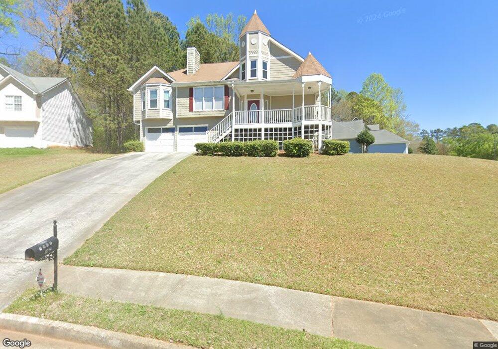
7868 Tower Ct Douglasville, GA 30134
Estimated Value: $268,068 - $313,000
3
Beds
3
Baths
1,488
Sq Ft
$194/Sq Ft
Est. Value
About This Home
This home is located at 7868 Tower Ct, Douglasville, GA 30134 and is currently estimated at $288,767, approximately $194 per square foot. 7868 Tower Ct is a home located in Douglas County with nearby schools including North Douglas Elementary School, Stewart Middle School, and Douglas County High School.
Ownership History
Date
Name
Owned For
Owner Type
Purchase Details
Closed on
Jun 13, 1997
Sold by
Vintage Builders Inc
Bought by
Britt Diane
Current Estimated Value
Home Financials for this Owner
Home Financials are based on the most recent Mortgage that was taken out on this home.
Original Mortgage
$82,000
Outstanding Balance
$11,684
Interest Rate
7.93%
Mortgage Type
New Conventional
Estimated Equity
$277,083
Purchase Details
Closed on
Feb 21, 1997
Sold by
Bjf Assoc
Bought by
Vintage Bldrs
Create a Home Valuation Report for This Property
The Home Valuation Report is an in-depth analysis detailing your home's value as well as a comparison with similar homes in the area
Home Values in the Area
Average Home Value in this Area
Purchase History
| Date | Buyer | Sale Price | Title Company |
|---|---|---|---|
| Britt Diane | $119,900 | -- | |
| Vintage Bldrs | $16,000 | -- |
Source: Public Records
Mortgage History
| Date | Status | Borrower | Loan Amount |
|---|---|---|---|
| Open | Britt Diane | $82,000 | |
| Closed | Vintage Bldrs | $0 |
Source: Public Records
Tax History Compared to Growth
Tax History
| Year | Tax Paid | Tax Assessment Tax Assessment Total Assessment is a certain percentage of the fair market value that is determined by local assessors to be the total taxable value of land and additions on the property. | Land | Improvement |
|---|---|---|---|---|
| 2024 | $1,624 | $100,840 | $21,720 | $79,120 |
| 2023 | $1,624 | $100,840 | $21,720 | $79,120 |
| 2022 | $1,277 | $80,760 | $14,000 | $66,760 |
| 2021 | $1,176 | $67,240 | $14,000 | $53,240 |
| 2020 | $2,419 | $63,160 | $10,480 | $52,680 |
| 2019 | $2,268 | $61,720 | $10,480 | $51,240 |
| 2018 | $2,438 | $66,920 | $11,760 | $55,160 |
| 2017 | $1,874 | $49,480 | $9,640 | $39,840 |
| 2016 | $1,845 | $47,960 | $9,640 | $38,320 |
| 2015 | $1,185 | $30,920 | $6,440 | $24,480 |
| 2014 | $884 | $24,280 | $5,400 | $18,880 |
| 2013 | -- | $23,720 | $5,280 | $18,440 |
Source: Public Records
Map
Nearby Homes
- 0 Davis Dr Unit 10626722
- 0 Davis Dr Unit 10626705
- 7900 Alpha Way Unit 1
- 6803 John Clark Dr
- 8051 Dallas Hwy
- 6592 Malone Rd
- 6588 Snowbird Ln Unit 1
- 7631 Dallas Hwy
- 7631 Dallas Hwy Unit D035
- 6859 John Clark Dr
- 6861 John Clark Dr
- 8068 Greene Ct
- 7835 Teton Trail Unit 1
- 8090 Colquitt St
- 1160 Pleasant Oak Ln
- 7104 Skippingstone Way
- 7712 Autry Cir
- 7712 Autry Cir Unit 208
- 7712 Autry Cir Unit 201
- 7712 Autry Cir Unit 617
- 6740 John Clark Dr
- 0 Tower Ct Unit 7093052
- 0 Tower Ct
- 7862 Tower Ct
- 6732 John Clark Dr
- 6776 John Clark Dr Unit 1
- 7856 Tower Ct
- 6743 John Clark Dr
- 6724 John Clark Dr Unit 1
- 6780 John Clark Dr
- 6737 John Clark Dr Unit 1
- 6771 John Clark Dr Unit 1
- 6720 Davis Dr
- 6731 John Clark Dr
- 0 Alpha Way
- 6716 John Clark Dr
- 6786 John Clark Dr Unit 1
- 7851 Tower Ct
- 7910 Tower Dr Unit 1
- 6795 Davis Dr