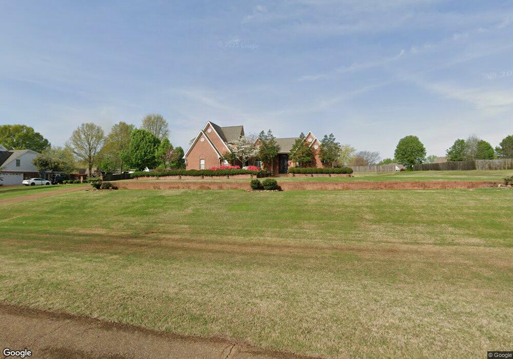
7871 Windersgate Cir Olive Branch, MS 38654
Estimated Value: $447,000 - $512,000
4
Beds
3
Baths
3,784
Sq Ft
$126/Sq Ft
Est. Value
About This Home
This home is located at 7871 Windersgate Cir, Olive Branch, MS 38654 and is currently estimated at $478,181, approximately $126 per square foot. 7871 Windersgate Cir is a home located in DeSoto County with nearby schools including Olive Branch Elementary School, Chickasaw Elementary School, and Olive Branch Middle School.
Ownership History
Date
Name
Owned For
Owner Type
Purchase Details
Closed on
Jun 15, 2020
Sold by
Smith Farmer Janice
Bought by
Farmer Derrick Earl
Current Estimated Value
Home Financials for this Owner
Home Financials are based on the most recent Mortgage that was taken out on this home.
Original Mortgage
$199,267
Interest Rate
2.71%
Mortgage Type
VA
Create a Home Valuation Report for This Property
The Home Valuation Report is an in-depth analysis detailing your home's value as well as a comparison with similar homes in the area
Home Values in the Area
Average Home Value in this Area
Purchase History
| Date | Buyer | Sale Price | Title Company |
|---|---|---|---|
| Farmer Derrick Earl | -- | Amrock Inc |
Source: Public Records
Mortgage History
| Date | Status | Borrower | Loan Amount |
|---|---|---|---|
| Closed | Farmer Derrick Earl | $199,267 |
Source: Public Records
Tax History
| Year | Tax Paid | Tax Assessment Tax Assessment Total Assessment is a certain percentage of the fair market value that is determined by local assessors to be the total taxable value of land and additions on the property. | Land | Improvement |
|---|---|---|---|---|
| 2025 | $4,434 | $40,880 | $3,000 | $37,880 |
| 2024 | $3,696 | $29,278 | $3,000 | $26,278 |
| 2023 | $3,696 | $29,278 | $0 | $0 |
| 2022 | $3,696 | $29,278 | $3,000 | $26,278 |
| 2021 | $3,696 | $29,278 | $3,000 | $26,278 |
| 2020 | $3,409 | $27,178 | $3,000 | $24,178 |
| 2019 | $3,409 | $27,178 | $3,000 | $24,178 |
| 2017 | $3,382 | $50,672 | $26,836 | $23,836 |
| 2016 | $3,382 | $26,836 | $3,000 | $23,836 |
| 2015 | $3,682 | $50,672 | $26,836 | $23,836 |
| 2014 | $2,721 | $28,153 | $0 | $0 |
| 2013 | $3,433 | $28,153 | $0 | $0 |
Source: Public Records
Map
Nearby Homes
- 7738 Windersgate Cir
- 8017 Camptown Ln
- 8699 Courtly Cir N
- 8798 Hunters Horn Cove
- 8321 Windersgate Dr
- 8040 Hunt Club Cove
- 8830 Courtly Cir S
- 8390 Ms-178
- 7885 Hunters Bend Cove
- 8870 Collinswood Dr
- 7961 Allendale Cove
- 7922 Allendale Cove
- 8280 Germantown Rd
- 9002 Lakeside Cove
- 7944 Allenwood Ln
- 7827 Germantown Rd
- 7831 Ferndale Dr
- 7689 Germantown Rd
- 9194 Rosalie Cove Unit Rosalie Cove
- 9160 Plantation Rd
- 7829 Windersgate Cir
- 7913 Windersgate Cir
- 7902 Windersgate Cir
- 7892 Windersgate Cir
- 7944 Windersgate Cir
- 7860 Windersgate Cir
- 7934 Windersgate Cir
- 7850 Windersgate Cir
- 7787 Windersgate Cir
- 7955 Windersgate Cir
- 7972 Windersgate Cir
- 7818 Windersgate Cir
- 7976 Windersgate Cir
- 7887 Windersgate Cir
- 7822 Windersgate Cir
- 7929 Windersgate Cir
- 7997 Windersgate Cir
- 8000 Windersgate Cir
- 8490 Westbrook Dr
- 7817 Windersgate Cir
Your Personal Tour Guide
Ask me questions while you tour the home.