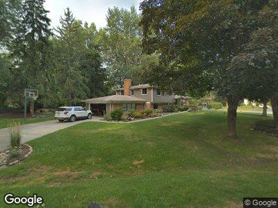
788 Robinhood Cir Bloomfield Hills, MI 48304
Estimated Value: $586,767 - $638,000
5
Beds
3
Baths
2,191
Sq Ft
$279/Sq Ft
Est. Value
About This Home
This home is located at 788 Robinhood Cir, Bloomfield Hills, MI 48304 and is currently estimated at $610,942, approximately $278 per square foot. 788 Robinhood Cir is a home located in Oakland County with nearby schools including Harlan Elementary School, Derby Middle School, and Ernest W. Seaholm High School.
Ownership History
Date
Name
Owned For
Owner Type
Purchase Details
Closed on
May 10, 2010
Sold by
Stewart Carlton A and Stewart Mary Lou
Bought by
Ballard Stephen D and Pott Ballard Jessica E
Current Estimated Value
Home Financials for this Owner
Home Financials are based on the most recent Mortgage that was taken out on this home.
Original Mortgage
$204,209
Interest Rate
5.37%
Mortgage Type
FHA
Create a Home Valuation Report for This Property
The Home Valuation Report is an in-depth analysis detailing your home's value as well as a comparison with similar homes in the area
Home Values in the Area
Average Home Value in this Area
Purchase History
| Date | Buyer | Sale Price | Title Company |
|---|---|---|---|
| Ballard Stephen D | $206,960 | Capital Title Ins Agency |
Source: Public Records
Mortgage History
| Date | Status | Borrower | Loan Amount |
|---|---|---|---|
| Open | Ballard Stephen D | $145,000 | |
| Closed | Ballard Stephen D | $63,300 | |
| Closed | Ballard Stephen D | $202,500 | |
| Closed | Ballard Stephen D | $204,209 |
Source: Public Records
Tax History Compared to Growth
Tax History
| Year | Tax Paid | Tax Assessment Tax Assessment Total Assessment is a certain percentage of the fair market value that is determined by local assessors to be the total taxable value of land and additions on the property. | Land | Improvement |
|---|---|---|---|---|
| 2024 | $2,605 | $247,220 | $0 | $0 |
| 2023 | $2,500 | $230,870 | $0 | $0 |
| 2022 | $4,232 | $215,680 | $0 | $0 |
| 2021 | $4,268 | $219,330 | $0 | $0 |
| 2020 | $2,402 | $205,480 | $0 | $0 |
| 2019 | $4,261 | $150,190 | $0 | $0 |
| 2018 | $4,229 | $143,340 | $0 | $0 |
| 2017 | $4,227 | $140,140 | $0 | $0 |
| 2016 | $4,250 | $135,870 | $0 | $0 |
| 2015 | -- | $122,230 | $0 | $0 |
| 2014 | -- | $106,010 | $0 | $0 |
| 2011 | -- | $102,790 | $0 | $0 |
Source: Public Records
Map
Nearby Homes
- 4540 Burnley Dr
- 4743 Burnley Dr
- 4321 Meadowlane Ct
- 4535 Kirkcaldy Rd
- 4755 Dover Rd
- 2755 Townhill
- 3406 Upton Dr
- 2653 W Wattles Rd
- 2570 Binbrooke Dr
- 4144 Rouge Circle Dr
- 458 Steeple Chase Ct
- 711 Hickory Heights Dr
- 3125 N Adams Rd
- 4360 Squirrel Rd
- 4675 Avondale Terrace
- 4389 Charing Way
- 3183 Oakhill Dr
- 3226 Wendover Rd
- 2960 Timberwyck Trail Dr
- 796 Rock Spring Rd
- 788 Robinhood Cir
- 796 Robinhood Cir
- 752 Robinhood Cir
- 783 Robinhood Cir
- 791 Robinhood Cir
- 767 Robinhood Cir
- 777 Robinhood Cir
- 704 Robinhood Cir
- 728 Robinhood Cir
- 759 Robinhood Cir
- 3821 N Adams Rd
- 751 Robinhood Cir
- 811 Robinhood Rd
- 810 Robinhood Ct
- 3841 N Adams Rd
- 3801 N Adams Rd
- 719 Robinhood Cir
- 743 Robinhood Cir
- 727 Robinhood Cir
- 711 Robinhood Cir