Estimated Value: $156,000 - $207,000
3
Beds
2
Baths
1,312
Sq Ft
$146/Sq Ft
Est. Value
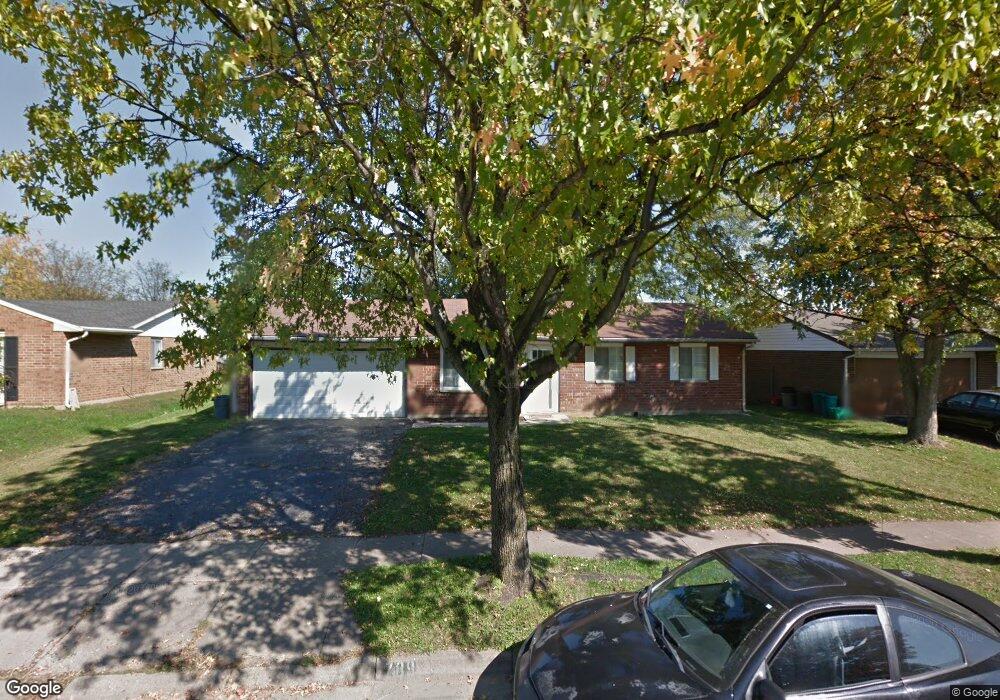
About This Home
This home is located at 789 Colorado Dr, Xenia, OH 45385 and is currently estimated at $191,863, approximately $146 per square foot. 789 Colorado Dr is a home located in Greene County with nearby schools including Xenia High School and Summit Academy Community School for Alternative Learners - Xenia.
Ownership History
Date
Name
Owned For
Owner Type
Purchase Details
Closed on
Oct 23, 2023
Sold by
Phillips William A and Phillips Michelle A
Bought by
Halcom Erika R and Phillips Brandan
Current Estimated Value
Home Financials for this Owner
Home Financials are based on the most recent Mortgage that was taken out on this home.
Original Mortgage
$124,000
Outstanding Balance
$121,589
Interest Rate
7.18%
Mortgage Type
Credit Line Revolving
Estimated Equity
$70,274
Purchase Details
Closed on
Jun 30, 1999
Sold by
Clark Geneva J
Bought by
Phillips William A and Phillips Michelle A
Home Financials for this Owner
Home Financials are based on the most recent Mortgage that was taken out on this home.
Original Mortgage
$81,851
Interest Rate
7.29%
Mortgage Type
FHA
Create a Home Valuation Report for This Property
The Home Valuation Report is an in-depth analysis detailing your home's value as well as a comparison with similar homes in the area
Home Values in the Area
Average Home Value in this Area
Purchase History
| Date | Buyer | Sale Price | Title Company |
|---|---|---|---|
| Halcom Erika R | $134,000 | None Listed On Document | |
| Phillips William A | $81,900 | Midland Title Security Inc |
Source: Public Records
Mortgage History
| Date | Status | Borrower | Loan Amount |
|---|---|---|---|
| Open | Halcom Erika R | $124,000 | |
| Previous Owner | Phillips William A | $81,851 |
Source: Public Records
Tax History Compared to Growth
Tax History
| Year | Tax Paid | Tax Assessment Tax Assessment Total Assessment is a certain percentage of the fair market value that is determined by local assessors to be the total taxable value of land and additions on the property. | Land | Improvement |
|---|---|---|---|---|
| 2024 | $2,208 | $51,610 | $11,590 | $40,020 |
| 2023 | $2,208 | $51,610 | $11,590 | $40,020 |
| 2022 | $1,793 | $36,660 | $6,820 | $29,840 |
| 2021 | $1,817 | $36,660 | $6,820 | $29,840 |
| 2020 | $1,739 | $36,660 | $6,820 | $29,840 |
| 2019 | $1,577 | $31,290 | $6,580 | $24,710 |
| 2018 | $1,583 | $31,290 | $6,580 | $24,710 |
| 2017 | $1,537 | $31,290 | $6,580 | $24,710 |
| 2016 | $1,451 | $28,150 | $6,580 | $21,570 |
| 2015 | $1,455 | $28,150 | $6,580 | $21,570 |
| 2014 | $1,391 | $28,150 | $6,580 | $21,570 |
Source: Public Records
Map
Nearby Homes
- 1829 Gayhart Dr
- 2257 Maryland Dr
- 1769 Gayhart Dr
- 2142 Michigan Dr
- 1908 Whitt St
- 1107 Arkansas Dr
- 2545 Harmony Dr
- 1403 Texas Dr
- 1255 Colorado Dr
- 414 Whisper Ln
- 2345 Tennessee Dr
- 1653 Seneca Dr
- 1866 Roxbury Dr
- 1778 Arapaho Dr
- 2758 Wyoming Dr
- 2499 Jenny Marie Dr
- 1618 Navajo Dr
- 219 Kansas Dr
- 2421 Louisiana Dr
- 2540 Jenny Marie Dr
- 777 Colorado Dr
- 801 Colorado Dr
- 759 Colorado Dr
- 2067 Maryland Dr
- 2066 Alabama Dr
- 757 Colorado Dr
- 2081 Maryland Dr
- 837 Colorado Dr
- 2080 Alabama Dr
- 2078 Maryland Dr
- 2069 Alabama Dr
- 2097 Maryland Dr
- 2096 Alabama Dr
- 2029 Nebraska Dr
- 849 Colorado Dr
- 2015 Nebraska Dr
- 2090 Maryland Dr
- 2001 Nebraska Dr
- 2083 Alabama Dr
- 2065 Nebraska Dr