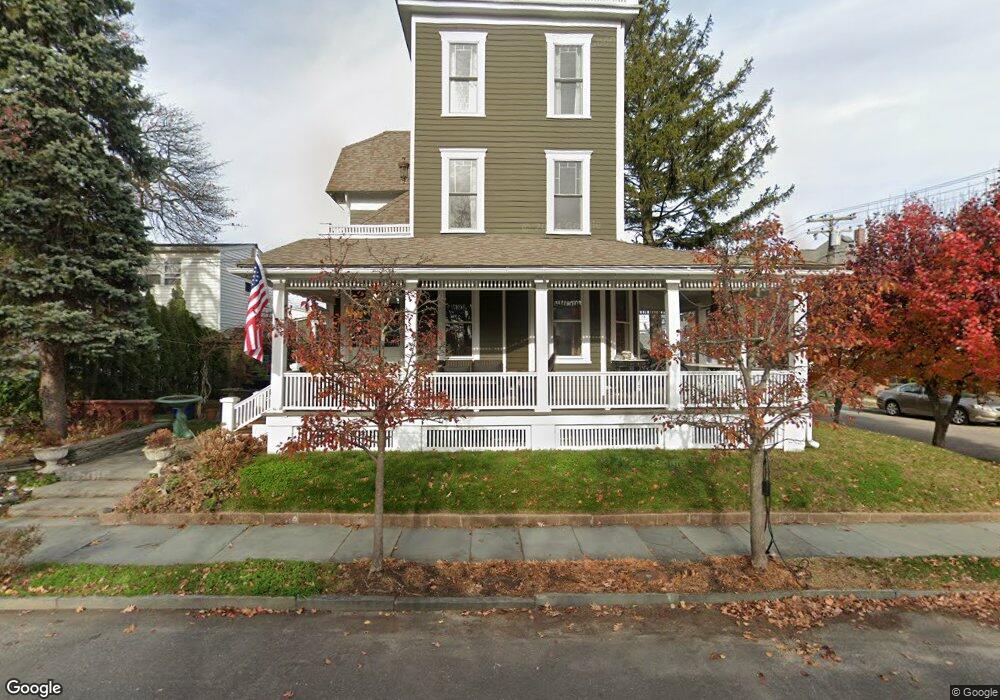
79 Cookman Ave Ocean Grove, NJ 07756
Estimated Value: $1,235,000 - $1,454,000
4
Beds
1
Bath
2,113
Sq Ft
$634/Sq Ft
Est. Value
About This Home
This home is located at 79 Cookman Ave, Ocean Grove, NJ 07756 and is currently estimated at $1,338,767, approximately $633 per square foot. 79 Cookman Ave is a home located in Monmouth County with nearby schools including Neptune High School, Hope Academy Charter School, and Our Lady of Mount Carmel School.
Ownership History
Date
Name
Owned For
Owner Type
Purchase Details
Closed on
Aug 22, 2024
Sold by
Puches Russell and Mulligan Linda
Bought by
Puches Russell and Puches Linda
Current Estimated Value
Purchase Details
Closed on
Mar 14, 1996
Sold by
Tribble Cassandra
Bought by
Puches Russell and Mulligan Linda
Home Financials for this Owner
Home Financials are based on the most recent Mortgage that was taken out on this home.
Original Mortgage
$4,000
Interest Rate
6.97%
Create a Home Valuation Report for This Property
The Home Valuation Report is an in-depth analysis detailing your home's value as well as a comparison with similar homes in the area
Home Values in the Area
Average Home Value in this Area
Purchase History
| Date | Buyer | Sale Price | Title Company |
|---|---|---|---|
| Puches Russell | -- | None Listed On Document | |
| Puches Russell | $116,000 | -- |
Source: Public Records
Mortgage History
| Date | Status | Borrower | Loan Amount |
|---|---|---|---|
| Previous Owner | Puches Russell | $4,000 |
Source: Public Records
Tax History Compared to Growth
Tax History
| Year | Tax Paid | Tax Assessment Tax Assessment Total Assessment is a certain percentage of the fair market value that is determined by local assessors to be the total taxable value of land and additions on the property. | Land | Improvement |
|---|---|---|---|---|
| 2025 | $21,187 | $1,270,300 | $636,500 | $633,800 |
| 2024 | $16,308 | $1,232,500 | $481,800 | $750,700 |
| 2023 | $16,308 | $919,300 | $474,800 | $444,500 |
| 2022 | $14,126 | $788,400 | $365,200 | $423,200 |
| 2021 | $12,640 | $680,100 | $354,700 | $325,400 |
| 2020 | $13,200 | $633,100 | $324,700 | $308,400 |
| 2019 | $12,640 | $598,200 | $308,900 | $289,300 |
| 2018 | $12,725 | $596,000 | $308,900 | $287,100 |
| 2017 | $12,695 | $570,300 | $304,500 | $265,800 |
| 2016 | $12,017 | $538,900 | $277,300 | $261,600 |
| 2015 | $11,603 | $529,800 | $274,500 | $255,300 |
| 2014 | $10,841 | $406,800 | $198,000 | $208,800 |
Source: Public Records
Map
Nearby Homes
- 69 Webb Ave
- 56 Embury Ave
- 77 Stockton Ave
- 52 Embury Ave
- 93 Central Ave
- 69 Stockton Ave
- 128 Broadway
- 66 Main Ave
- 77 Main Ave Unit 2B
- 77 Main Ave Unit 2A
- 139 Cookman Ave
- 54 Olin St
- 20 Webb Ave
- 68 Mount Tabor Way Unit 2
- 68 Mount Tabor Way
- 18 Abbott Ave
- 147 Webb Ave
- 26 Heck Ave
- 110 Mount Tabor Way
- 139 Stockton Ave
- 83 Cookman Ave
- 82 Broadway
- 85 Cookman Ave
- 80 Broadway
- 84 Broadway
- 86 Broadway
- 87 Cookman Ave
- 87 Cookman Ave Unit WEEKLY/SUMMER
- 87 Cookman Ave Unit SUMMER/WEEKLY
- 77 Cookman Ave
- 88 Broadway
- 78 Broadway
- 98 Pennsylvania Ave Unit 6
- 98 Pennsylvania Ave Unit 2
- 98 Pennsylvania Ave Unit 5
- 98 Pennsylvania Ave Unit 3
- 98 Pennsylvania Ave Unit 4
- 98 Pennsylvania Ave Unit 1
- 90 Broadway
- 76 Broadway