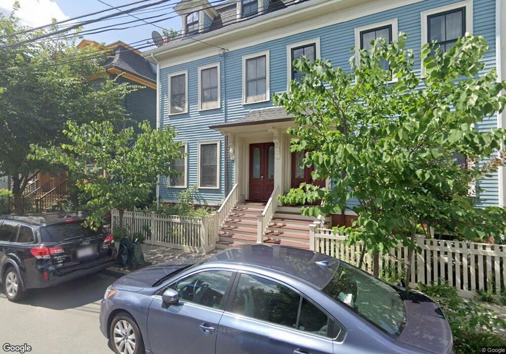
79 Pearl St Cambridge, MA 02139
Cambridgeport NeighborhoodEstimated Value: $1,556,000 - $1,913,000
3
Beds
4
Baths
1,912
Sq Ft
$935/Sq Ft
Est. Value
About This Home
This home is located at 79 Pearl St, Cambridge, MA 02139 and is currently estimated at $1,788,667, approximately $935 per square foot. 79 Pearl St is a home located in Middlesex County with nearby schools including Edward M. Kennedy Academy for Health Careers and Torit Montessori School.
Ownership History
Date
Name
Owned For
Owner Type
Purchase Details
Closed on
Jun 12, 1978
Bought by
Tibbs William R
Current Estimated Value
Create a Home Valuation Report for This Property
The Home Valuation Report is an in-depth analysis detailing your home's value as well as a comparison with similar homes in the area
Home Values in the Area
Average Home Value in this Area
Purchase History
| Date | Buyer | Sale Price | Title Company |
|---|---|---|---|
| Tibbs William R | $18,000 | -- |
Source: Public Records
Mortgage History
| Date | Status | Borrower | Loan Amount |
|---|---|---|---|
| Closed | Tibbs William R | $303,000 | |
| Closed | Tibbs William R | $200,001 | |
| Closed | Tibbs William R | $30,000 |
Source: Public Records
Tax History Compared to Growth
Tax History
| Year | Tax Paid | Tax Assessment Tax Assessment Total Assessment is a certain percentage of the fair market value that is determined by local assessors to be the total taxable value of land and additions on the property. | Land | Improvement |
|---|---|---|---|---|
| 2025 | $7,163 | $1,128,100 | $651,700 | $476,400 |
| 2024 | $6,955 | $1,174,900 | $715,900 | $459,000 |
| 2023 | $6,475 | $1,104,900 | $691,600 | $413,300 |
| 2022 | $6,569 | $1,109,700 | $736,000 | $373,700 |
| 2021 | $6,637 | $1,057,000 | $680,600 | $376,400 |
| 2020 | $5,715 | $993,900 | $645,800 | $348,100 |
| 2019 | $5,296 | $891,500 | $563,300 | $328,200 |
| 2018 | $5,479 | $796,600 | $495,300 | $301,300 |
| 2017 | $5,182 | $798,500 | $485,600 | $312,900 |
| 2016 | $4,702 | $672,700 | $383,600 | $289,100 |
| 2015 | $4,594 | $587,500 | $335,100 | $252,400 |
| 2014 | $4,355 | $519,700 | $318,100 | $201,600 |
Source: Public Records
Map
Nearby Homes
- 129 Auburn St
- 127 Auburn St
- 300 Franklin St Unit 5
- 300 Franklin St Unit 1
- 300 Franklin St Unit 2
- 73 River St Unit 4B
- 6-8 Watson St Unit 8
- 8 Watson St Unit 8
- 125 Brookline St Unit 4
- 1 Jay St
- 12 Inman St Unit 55
- 149A Bishop Allen Unit A
- 131 Erie St Unit 3
- 131 Erie St
- 4 Saint Paul St
- 161 Hamilton St
- 863 Massachusetts Ave Unit 25
- 53 Jay St Unit 2
- 174 Hamilton St
- 28 Inman St Unit 4
- 77 Pearl St
- 3 William St
- 85 Pearl St
- 71 Pearl St Unit 2
- 71 Pearl St Unit 3
- 71 Pearl St Unit 1
- 71 Pearl St
- 5 William St
- 78 Pearl St Unit 78
- 78 Pearl St Unit 1
- 78 Pearl St
- 80 Pearl St
- 84 Pearl St
- 88 Pearl St
- 88 Pearl St Unit 2
- 88 Pearl St Unit 1
- 2 William St Unit 2
- 93 Pearl St
- 9 William St
- 156-r Auburn St Unit 156