Estimated Value: $107,000 - $360,000
3
Beds
1
Bath
963
Sq Ft
$193/Sq Ft
Est. Value
About This Home
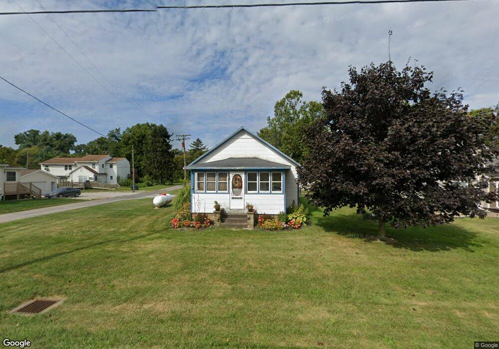
This home is located at 7907 State Route 61, Huron, OH 44839 and is currently estimated at $185,398, approximately $192 per square foot. 7907 State Route 61 is a home with nearby schools including Edison Elementary School (Formerly Milan Elementary), Edison Middle School (Formerly Berlin-Milan Middle School), and Edison High School.
Ownership History
Date
Name
Owned For
Owner Type
Purchase Details
Closed on
Jan 17, 2015
Sold by
Church James F and Church Diane S
Bought by
Church James F and Church Revoca Diane S
Current Estimated Value
Purchase Details
Closed on
Mar 10, 2005
Sold by
Boyer Richard E and Richard E Boyer Declaration Of
Bought by
Church James F and Church Ciane S
Purchase Details
Closed on
Dec 13, 1994
Sold by
Haynes Clara
Bought by
Boyer Richard E
Create a Home Valuation Report for This Property
The Home Valuation Report is an in-depth analysis detailing your home's value as well as a comparison with similar homes in the area
Home Values in the Area
Average Home Value in this Area
Purchase History
| Date | Buyer | Sale Price | Title Company |
|---|---|---|---|
| Church James F | -- | None Available | |
| Church James F | $61,000 | Lawyers Title Ins Corp | |
| Boyer Richard E | $34,000 | -- |
Source: Public Records
Tax History
| Year | Tax Paid | Tax Assessment Tax Assessment Total Assessment is a certain percentage of the fair market value that is determined by local assessors to be the total taxable value of land and additions on the property. | Land | Improvement |
|---|---|---|---|---|
| 2024 | $1,031 | $27,335 | $5,775 | $21,560 |
| 2023 | $1,050 | $21,273 | $5,250 | $16,023 |
| 2022 | $902 | $21,273 | $5,250 | $16,023 |
| 2021 | $896 | $21,270 | $5,250 | $16,020 |
| 2020 | $877 | $20,470 | $5,250 | $15,220 |
| 2019 | $910 | $20,470 | $5,250 | $15,220 |
| 2018 | $1,104 | $20,470 | $5,250 | $15,220 |
| 2017 | $926 | $19,480 | $7,860 | $11,620 |
| 2016 | $919 | $19,480 | $7,860 | $11,620 |
| 2015 | $906 | $19,480 | $7,860 | $11,620 |
| 2014 | $941 | $19,480 | $7,860 | $11,620 |
| 2013 | $929 | $19,480 | $7,860 | $11,620 |
Source: Public Records
Map
Nearby Homes
- 7305 Darrow Rd
- 7311 Freeman Ln
- 3713 Cleveland Rd E
- 4018 Cleveland Rd E
- 508 Snowy Egret Dr
- 1505 Cleveland Rd E Unit 331
- 1505 Cleveland Rd E Unit 334
- 1110 By the Shores Dr Unit 4
- 1120 By the Shores Dr Unit 2
- 1100 By-The-shores Dr Unit 1
- 38 VL Youness
- 5605 W Lake Rd Unit 155
- 5605 W Lake Rd Unit 20
- 5605 W Lake Rd Unit 9
- 5605 W Lake Rd Unit 8
- 5605 W Lake Rd Unit 154
- 5605 W Lake Rd Unit 146
- 5605 W Lake Rd Unit 23
- 5605 W Lake Rd Unit 25
- 5605 W Lake Rd Unit 4
- 7911 State Route 61
- 7903 Ceylon Rd
- 7213 Elm St
- 7819 State Route 61
- 7220 Depot St S
- 8006 State Route 61
- 7306 Depot St S
- 7718 State Route 61
- 7316 Depot St S
- 7401 Depot St N
- 7318 Depot St S
- 7405 Depot St N
- 7320 Depot St S
- 7411 Depot St N
- 7406 Depot St S
- 7412 Depot St S
- 7617 State Route 61
- 5618 State Rd 6 Unit B
- 3317 Cleveland Rd E
- 3508 Cleveland Rd E
Your Personal Tour Guide
Ask me questions while you tour the home.