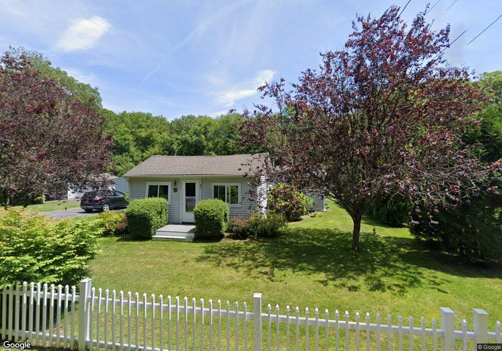
791 Broad Rock Rd Wakefield, RI 02879
Estimated Value: $375,000 - $473,000
2
Beds
1
Bath
963
Sq Ft
$458/Sq Ft
Est. Value
About This Home
This home is located at 791 Broad Rock Rd, Wakefield, RI 02879 and is currently estimated at $440,688, approximately $457 per square foot. 791 Broad Rock Rd is a home located in Washington County with nearby schools including South Kingstown High School, Monsignor Matthew Clarke Catholic Regional School, and South Shore School.
Ownership History
Date
Name
Owned For
Owner Type
Purchase Details
Closed on
Sep 30, 2004
Sold by
Briggs James E F and Briggs Amy M
Bought by
Deschenes Philip D and Deschenes Christina M
Current Estimated Value
Create a Home Valuation Report for This Property
The Home Valuation Report is an in-depth analysis detailing your home's value as well as a comparison with similar homes in the area
Home Values in the Area
Average Home Value in this Area
Purchase History
| Date | Buyer | Sale Price | Title Company |
|---|---|---|---|
| Deschenes Philip D | $168,500 | -- |
Source: Public Records
Mortgage History
| Date | Status | Borrower | Loan Amount |
|---|---|---|---|
| Open | Deschenes Philip D | $186,914 | |
| Closed | Deschenes Philip D | $209,708 | |
| Closed | Deschenes Philip D | $47,000 |
Source: Public Records
Tax History
| Year | Tax Paid | Tax Assessment Tax Assessment Total Assessment is a certain percentage of the fair market value that is determined by local assessors to be the total taxable value of land and additions on the property. | Land | Improvement |
|---|---|---|---|---|
| 2025 | $3,205 | $358,500 | $162,700 | $195,800 |
| 2024 | $3,108 | $281,300 | $125,000 | $156,300 |
| 2023 | $3,108 | $281,300 | $125,000 | $156,300 |
| 2022 | $3,080 | $281,300 | $125,000 | $156,300 |
| 2021 | $3,061 | $211,800 | $103,100 | $108,700 |
| 2020 | $3,061 | $211,800 | $103,100 | $108,700 |
| 2019 | $3,061 | $211,800 | $103,100 | $108,700 |
| 2018 | $2,974 | $189,700 | $99,600 | $90,100 |
| 2017 | $2,904 | $189,700 | $99,600 | $90,100 |
| 2016 | $2,863 | $189,700 | $99,600 | $90,100 |
| 2015 | $2,856 | $184,000 | $93,600 | $90,400 |
| 2014 | $2,848 | $184,000 | $93,600 | $90,400 |
Source: Public Records
Map
Nearby Homes
- 261 Saugatucket Rd
- 0 Indian Trail Trail S Unit 1389828
- 95 S Woods Dr
- 0 Indian Run Trail Unit 1403300
- 15 Jessica Ln
- 57 Rocky Brook Way
- 301 Church St Unit 103
- 48 Stone Bridge Dr
- 9 Edwards Ave
- 131 Columbia St
- 143 Summit Ave
- 37 Columbia St
- 20 Cleveland St
- 45 Cherry Ln Unit C
- 39 Hazard Ave
- 5 Wayland Trail
- 40 Northup St
- 260 Sweet Allen Farm Rd Unit 3
- 416 Bridgetown Rd
- 50 Shadow Farm Way
- 781 Broad Rock Rd
- 786 Broad Rock Rd
- 765 Broad Rock Rd
- 815 Broad Rock Rd
- 770 Broad Rock Rd
- 760 Broad Rock Rd
- 804 Broad Rock Rd
- 829 Broad Rock Rd
- 824 Broad Rock Rd
- 806 Broad Rock Rd
- 451 Broad Rock Rd
- 80 Broad Rock Rd
- 15 Dry Creek Farm Way
- 30 Woodmist Cir
- 59 Dry Creek Way
- 0 Woodmist Cir Unit 1048689
- 0 Woodmist Cir Unit 1037201
- 65 Dry Creek Way
- 843 Broad Rock Rd
- 15 Woodmist Cir
Your Personal Tour Guide
Ask me questions while you tour the home.