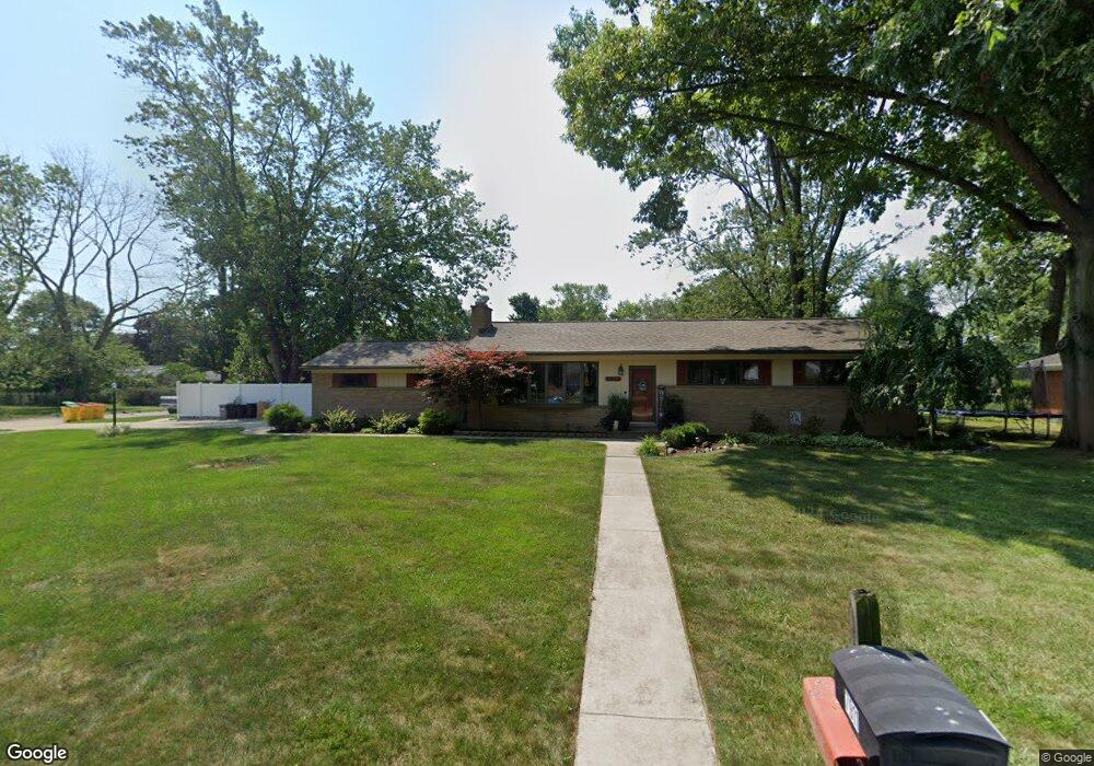
7911 Bournemouth Ave Grosse Ile, MI 48138
Estimated Value: $260,000 - $345,000
3
Beds
3
Baths
1,747
Sq Ft
$176/Sq Ft
Est. Value
About This Home
This home is located at 7911 Bournemouth Ave, Grosse Ile, MI 48138 and is currently estimated at $306,707, approximately $175 per square foot. 7911 Bournemouth Ave is a home located in Wayne County with nearby schools including St. Cyprian Elementary School.
Ownership History
Date
Name
Owned For
Owner Type
Purchase Details
Closed on
Oct 13, 2021
Sold by
Mccann James C and The Charies N Mahaney Trust
Bought by
Garza Nicole
Current Estimated Value
Purchase Details
Closed on
Sep 13, 2004
Sold by
Mahaney Charles N and Mahaney Ellen V
Bought by
Mahaney Charles N
Create a Home Valuation Report for This Property
The Home Valuation Report is an in-depth analysis detailing your home's value as well as a comparison with similar homes in the area
Home Values in the Area
Average Home Value in this Area
Purchase History
| Date | Buyer | Sale Price | Title Company |
|---|---|---|---|
| Garza Nicole | $200,000 | Ata National Title Group Llc | |
| Mahaney Charles N | -- | -- |
Source: Public Records
Tax History Compared to Growth
Tax History
| Year | Tax Paid | Tax Assessment Tax Assessment Total Assessment is a certain percentage of the fair market value that is determined by local assessors to be the total taxable value of land and additions on the property. | Land | Improvement |
|---|---|---|---|---|
| 2025 | $1,871 | $149,200 | $0 | $0 |
| 2024 | $1,871 | $131,900 | $0 | $0 |
| 2023 | $2,141 | $121,400 | $0 | $0 |
| 2022 | $4,982 | $111,700 | $0 | $0 |
| 2021 | $5,872 | $110,100 | $0 | $0 |
| 2019 | $5,694 | $97,300 | $0 | $0 |
| 2018 | $2,532 | $99,400 | $0 | $0 |
| 2017 | $6,079 | $96,100 | $0 | $0 |
| 2016 | $4,122 | $95,900 | $0 | $0 |
| 2015 | $8,778 | $89,000 | $0 | $0 |
| 2013 | $8,910 | $91,100 | $0 | $0 |
| 2012 | $1,886 | $87,900 | $28,400 | $59,500 |
Source: Public Records
Map
Nearby Homes
- 8258 Concord Rd
- 21604 E River Rd
- 21599 Parke Ln
- 21321 Knudsen Dr
- 20633 Canal Dr
- 21071 Thorofare Rd
- 21644 Knudsen Dr
- 22015 Ember Ct
- 22220 E River Rd
- 7806 Island Blvd
- 8232 Island Blvd
- 21438 Meridian Rd
- 8614 Island Blvd
- 21819 Meridian Rd
- 22133 Meridian Rd
- 9447 Whitall Ln
- 9281 Island Dr
- 20204 Island Estate Dr Unit 30
- 0 West River Unit 20250008619
- 9000 Ferry Rd
- 7935 Bournemouth Ave
- 000 Parke Ln Unit 12
- 000 Parke Ln
- 7934 Coventry Ave
- 7779 Bournemouth Ave
- 7910 Bournemouth Ave
- 7932 Bournemouth Ave
- 7782 Coventry Ave
- 7959 Bournemouth Ave
- 7958 Coventry Ave
- 7780 Bournemouth Ave
- 7954 Bournemouth Ave Unit Bldg-Unit
- 7954 Bournemouth Ave
- 7753 Bournemouth Ave
- 7758 Coventry Ave
- 7915 Coventry Ave
- 7983 Bournemouth Ave
- 7937 Coventry Ave
- 7756 Bournemouth Ave
- 7974 Bournemouth Ave