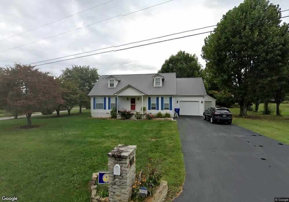
792 James Austin Rd Sparta, TN 38583
Estimated Value: $270,247 - $349,000
--
Bed
3
Baths
1,792
Sq Ft
$178/Sq Ft
Est. Value
About This Home
This home is located at 792 James Austin Rd, Sparta, TN 38583 and is currently estimated at $319,812, approximately $178 per square foot. 792 James Austin Rd is a home located in White County with nearby schools including Northfield Elementary School, White County Middle School, and White County High School.
Ownership History
Date
Name
Owned For
Owner Type
Purchase Details
Closed on
Jun 13, 2016
Sold by
Haney Jennifer L
Bought by
Murphy Jason S and Murphy Jennifer L
Current Estimated Value
Purchase Details
Closed on
Jun 26, 2003
Sold by
M & M Builders
Bought by
Jennifer Haney
Home Financials for this Owner
Home Financials are based on the most recent Mortgage that was taken out on this home.
Original Mortgage
$88,000
Interest Rate
5.29%
Purchase Details
Closed on
Jun 3, 2002
Sold by
M & M Builders
Bought by
Huddleston Earl M
Create a Home Valuation Report for This Property
The Home Valuation Report is an in-depth analysis detailing your home's value as well as a comparison with similar homes in the area
Home Values in the Area
Average Home Value in this Area
Purchase History
| Date | Buyer | Sale Price | Title Company |
|---|---|---|---|
| Murphy Jason S | -- | -- | |
| Jennifer Haney | $97,600 | -- | |
| Huddleston Earl M | -- | -- |
Source: Public Records
Mortgage History
| Date | Status | Borrower | Loan Amount |
|---|---|---|---|
| Previous Owner | Huddleston Earl M | $88,000 |
Source: Public Records
Tax History Compared to Growth
Tax History
| Year | Tax Paid | Tax Assessment Tax Assessment Total Assessment is a certain percentage of the fair market value that is determined by local assessors to be the total taxable value of land and additions on the property. | Land | Improvement |
|---|---|---|---|---|
| 2024 | $771 | $37,600 | $4,000 | $33,600 |
| 2023 | $771 | $37,600 | $4,000 | $33,600 |
| 2022 | $771 | $37,600 | $4,000 | $33,600 |
| 2021 | $771 | $37,600 | $4,000 | $33,600 |
| 2020 | $771 | $37,600 | $4,000 | $33,600 |
| 2019 | $680 | $33,175 | $4,000 | $29,175 |
| 2018 | $680 | $33,175 | $4,000 | $29,175 |
| 2017 | $680 | $33,175 | $4,000 | $29,175 |
| 2016 | $680 | $33,175 | $4,000 | $29,175 |
| 2015 | $614 | $33,175 | $4,000 | $29,175 |
| 2014 | -- | $33,175 | $4,000 | $29,175 |
| 2013 | -- | $30,925 | $4,000 | $26,925 |
Source: Public Records
Map
Nearby Homes
- 159 Rustling Oaks Dr
- 191 Rustling Oaks Dr
- 00 Milk Plant Rd
- 0 Saylor Rd
- 00 Saylor Rd
- 00 Oakcrest Dr
- 1045 Mullican Rd
- 366 S Bunker Hill Rd
- lot 7 James Holman Rd
- lot 6 James Holman Rd
- 3660 Burgess Falls Rd
- 147 Bob White Dr
- 221 Magnolia Rd
- 130 Mallard Dr
- 1236 Swamp Rd
- 2110 Almyra Rd
- 1298 S Bunker Hill Rd
- 165 Almyra Rd
- 160 Serenity Dr
- 22 Serenity Dr
- 121 Serenity Dr
- 155 Serenity Dr
- 227 Brook Dr
- 773 James Austin Rd
- 744 James Austin Rd
- 190 Serenity Dr
- 747 James Austin Rd
- 171 Serenity Dr
- 238 Brook Dr
- 210 Serenity Dr
- 181 Serenity Dr
- 191 Brook Dr
- 12 Serenity Dr
- 148 Prosperity Dr
- 7 Serenity Dr
- 133 Prosperity Dr
- 205 Serenity Dr
- 226 Serenity Dr