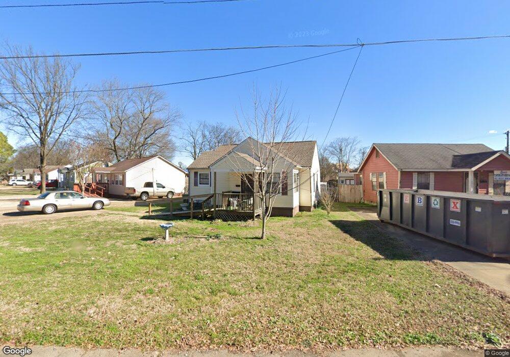
7928 Martha Rd Millington, TN 38053
Estimated Value: $111,000 - $123,902
2
Beds
1
Bath
846
Sq Ft
$140/Sq Ft
Est. Value
About This Home
This home is located at 7928 Martha Rd, Millington, TN 38053 and is currently estimated at $118,226, approximately $139 per square foot. 7928 Martha Rd is a home located in Shelby County with nearby schools including Millington High School, Lighthouse Christian Academy, and Woodlawn Baptist Academy.
Ownership History
Date
Name
Owned For
Owner Type
Purchase Details
Closed on
Jan 17, 2006
Sold by
Mccommon Myrtle Jean
Bought by
Waynemaxey Robert and Maxey Dorothy Marnell
Current Estimated Value
Home Financials for this Owner
Home Financials are based on the most recent Mortgage that was taken out on this home.
Original Mortgage
$55,800
Interest Rate
6.21%
Mortgage Type
Fannie Mae Freddie Mac
Purchase Details
Closed on
Dec 12, 2002
Sold by
Mccommon Myrtle J
Bought by
Mccommon Myrtle J and Myrtle Jean Mccommon Living Trust
Purchase Details
Closed on
Mar 30, 2000
Sold by
Gourley Raymond S and Gourley Elizabeth A
Bought by
Mccommon Myrtle J
Home Financials for this Owner
Home Financials are based on the most recent Mortgage that was taken out on this home.
Original Mortgage
$22,000
Interest Rate
8.34%
Create a Home Valuation Report for This Property
The Home Valuation Report is an in-depth analysis detailing your home's value as well as a comparison with similar homes in the area
Home Values in the Area
Average Home Value in this Area
Purchase History
| Date | Buyer | Sale Price | Title Company |
|---|---|---|---|
| Waynemaxey Robert | $62,000 | None Available | |
| Mccommon Myrtle J | -- | -- | |
| Mccommon Myrtle J | $37,000 | -- |
Source: Public Records
Mortgage History
| Date | Status | Borrower | Loan Amount |
|---|---|---|---|
| Closed | Waynemaxey Robert | $55,800 | |
| Previous Owner | Mccommon Myrtle J | $22,000 |
Source: Public Records
Tax History Compared to Growth
Tax History
| Year | Tax Paid | Tax Assessment Tax Assessment Total Assessment is a certain percentage of the fair market value that is determined by local assessors to be the total taxable value of land and additions on the property. | Land | Improvement |
|---|---|---|---|---|
| 2025 | -- | $25,550 | $3,225 | $22,325 |
| 2024 | $1,027 | $15,150 | $2,950 | $12,200 |
| 2023 | $726 | $15,150 | $2,950 | $12,200 |
| 2022 | $726 | $15,150 | $2,950 | $12,200 |
| 2021 | $735 | $15,150 | $2,950 | $12,200 |
| 2020 | $668 | $11,975 | $2,950 | $9,025 |
| 2019 | $485 | $11,975 | $2,950 | $9,025 |
| 2018 | $668 | $11,975 | $2,950 | $9,025 |
| 2017 | $675 | $11,975 | $2,950 | $9,025 |
| 2016 | $701 | $11,875 | $0 | $0 |
| 2014 | $519 | $11,875 | $0 | $0 |
Source: Public Records
Map
Nearby Homes
- 7988 Royster Creek Dr E
- 5852 U S Highway 51
- 4721 Janie Ave
- 4734 Janie Ave
- 4655 Doris Cir S
- 7963 Royster Creek Dr
- 7955 Royster Creek Dr
- 7943 Royster Creek Dr
- 7988 Royster Creek Dr
- 7932 Royster Creek Dr
- 7942 Royster Creek Dr
- 7980 Royster Creek Dr
- 7994 Royster Creek Dr
- 4752 Janie Cove
- Cali Plan at Huntington Estates
- Aria Plan at Huntington Estates
- Roland Plan at Huntington Estates
- Kerry Plan at Huntington Estates
- FREEPORT Plan at Huntington Estates
- 8852 U S 51