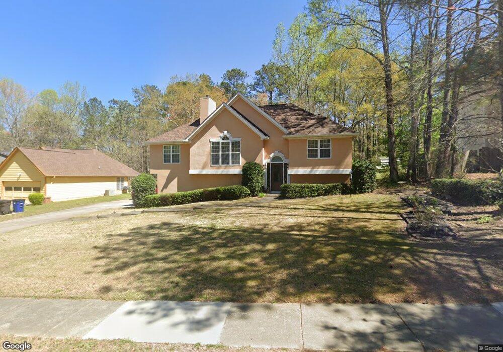
7944 Tower Dr Unit 1 Douglasville, GA 30134
Estimated Value: $274,098 - $308,000
3
Beds
3
Baths
1,521
Sq Ft
$192/Sq Ft
Est. Value
About This Home
This home is located at 7944 Tower Dr Unit 1, Douglasville, GA 30134 and is currently estimated at $292,275, approximately $192 per square foot. 7944 Tower Dr Unit 1 is a home located in Douglas County with nearby schools including North Douglas Elementary School, Stewart Middle School, and Douglas County High School.
Ownership History
Date
Name
Owned For
Owner Type
Purchase Details
Closed on
Apr 29, 2019
Sold by
Dorsey Patricia
Bought by
Bryant Joseph
Current Estimated Value
Purchase Details
Closed on
Nov 27, 1995
Sold by
Poston Assoc
Bought by
Bryant Joseph M Patricia
Purchase Details
Closed on
Aug 1, 1995
Sold by
Bjf Assoc Lp
Bought by
Poston Assoc
Create a Home Valuation Report for This Property
The Home Valuation Report is an in-depth analysis detailing your home's value as well as a comparison with similar homes in the area
Home Values in the Area
Average Home Value in this Area
Purchase History
| Date | Buyer | Sale Price | Title Company |
|---|---|---|---|
| Bryant Joseph | -- | -- | |
| Bryant Joseph M Patricia | $103,900 | -- | |
| Poston Assoc | $16,000 | -- |
Source: Public Records
Mortgage History
| Date | Status | Borrower | Loan Amount |
|---|---|---|---|
| Closed | Poston Assoc | $0 |
Source: Public Records
Tax History Compared to Growth
Tax History
| Year | Tax Paid | Tax Assessment Tax Assessment Total Assessment is a certain percentage of the fair market value that is determined by local assessors to be the total taxable value of land and additions on the property. | Land | Improvement |
|---|---|---|---|---|
| 2024 | $3,709 | $105,560 | $21,720 | $83,840 |
| 2023 | $3,709 | $105,560 | $21,720 | $83,840 |
| 2022 | $2,989 | $84,600 | $14,000 | $70,600 |
| 2021 | $2,608 | $70,600 | $14,000 | $56,600 |
| 2020 | $2,544 | $66,520 | $10,480 | $56,040 |
| 2019 | $2,387 | $65,000 | $10,480 | $54,520 |
| 2018 | $2,562 | $70,400 | $11,760 | $58,640 |
| 2017 | $1,976 | $52,040 | $9,640 | $42,400 |
| 2016 | $1,925 | $49,920 | $9,640 | $40,280 |
| 2015 | $1,252 | $32,520 | $6,440 | $26,080 |
| 2014 | $930 | $25,400 | $5,400 | $20,000 |
| 2013 | -- | $24,640 | $5,280 | $19,360 |
Source: Public Records
Map
Nearby Homes
- 7900 Alpha Way Unit 1
- 6803 John Clark Dr
- 0 Davis Dr Unit 10626722
- 0 Davis Dr Unit 10626705
- 8051 Dallas Hwy
- 8068 Greene Ct
- 6859 John Clark Dr
- 6861 John Clark Dr
- 6588 Snowbird Ln Unit 1
- 8090 Colquitt St
- 6592 Malone Rd
- 7631 Dallas Hwy
- 7631 Dallas Hwy Unit D035
- 7835 Teton Trail Unit 1
- 7104 Skippingstone Way
- 7099 Skippingstone Way
- 6648 Ridge Ave
- 7125 Creeksong Dr
- 8157 Brookbend Dr
- 1160 Pleasant Oak Ln
- 7930 Tower Dr
- 0 Tower Dr Unit 3142124
- 0 Tower Dr Unit 8855064
- 0 Tower Dr Unit 8238056
- 0 Tower Dr
- 7920 Tower Dr Unit 1
- 7966 Tower Dr Unit 1
- 7943 Tower Dr Unit 1
- 7955 Tower Dr Unit 1
- 7931 Tower Dr Unit 1
- 7939 Dallas Hwy
- 7939 Hwy 92 - Dallas Hwy
- 7939 Highway 92 Dallas Hwy
- 7910 Tower Dr Unit 1
- 7915 Tower Dr
- 7974 Tower Dr
- 7971 Tower Dr Unit 1
- 7915 Alpha Way
- 7925 Dallas Hwy
- 7937 Lake Stone Cir