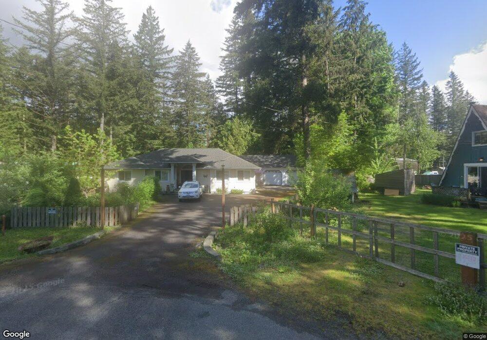
7955 Chisholm Trail Maple Falls, WA 98266
Estimated Value: $393,000 - $504,000
3
Beds
2
Baths
1,696
Sq Ft
$266/Sq Ft
Est. Value
About This Home
This home is located at 7955 Chisholm Trail, Maple Falls, WA 98266 and is currently estimated at $451,374, approximately $266 per square foot. 7955 Chisholm Trail is a home located in Whatcom County with nearby schools including Mount Baker Senior High School.
Ownership History
Date
Name
Owned For
Owner Type
Purchase Details
Closed on
Jun 24, 2025
Sold by
Bushaw Patricia Ann
Bought by
Bushaw Patricia Ann and Lillemo Luke
Current Estimated Value
Purchase Details
Closed on
Aug 20, 2012
Sold by
Vachon Barbara L
Bought by
Bushaw Patti
Home Financials for this Owner
Home Financials are based on the most recent Mortgage that was taken out on this home.
Original Mortgage
$75,000
Interest Rate
3.5%
Mortgage Type
New Conventional
Create a Home Valuation Report for This Property
The Home Valuation Report is an in-depth analysis detailing your home's value as well as a comparison with similar homes in the area
Home Values in the Area
Average Home Value in this Area
Purchase History
| Date | Buyer | Sale Price | Title Company |
|---|---|---|---|
| Bushaw Patricia Ann | $313 | None Listed On Document | |
| Bushaw Patti | $122,280 | Whatcom Land Title |
Source: Public Records
Mortgage History
| Date | Status | Borrower | Loan Amount |
|---|---|---|---|
| Previous Owner | Bushaw Patti | $75,000 |
Source: Public Records
Tax History Compared to Growth
Tax History
| Year | Tax Paid | Tax Assessment Tax Assessment Total Assessment is a certain percentage of the fair market value that is determined by local assessors to be the total taxable value of land and additions on the property. | Land | Improvement |
|---|---|---|---|---|
| 2024 | $377 | $417,087 | $90,000 | $327,087 |
| 2023 | $377 | $442,997 | $55,046 | $387,951 |
| 2022 | $465 | $354,402 | $44,038 | $169,145 |
| 2021 | $504 | $281,277 | $34,951 | $169,145 |
| 2020 | $520 | $221,480 | $27,521 | $193,959 |
| 2019 | $1,913 | $221,480 | $27,521 | $193,959 |
| 2018 | $2,050 | $193,145 | $24,000 | $169,145 |
| 2017 | $1,734 | $162,363 | $18,784 | $143,579 |
| 2016 | $1,674 | $146,501 | $16,960 | $129,541 |
| 2015 | $1,568 | $140,314 | $16,560 | $123,754 |
| 2014 | -- | $132,009 | $15,520 | $116,489 |
| 2013 | -- | $139,138 | $16,000 | $123,138 |
Source: Public Records
Map
Nearby Homes
- 7933 Oregon Trail
- 7900 Oregon Trail
- 7952 Apache Dr
- 7911 Oregon Trail
- 7945 Santa fe Trail
- 6284 Lariat Place
- 642 Sprague Valley Dr
- 6426 Santa fe Trail
- 6331 Overland Trail
- 8095 Mosey Ct
- 172 Sprague Valley Dr
- 6360 Overland Trail
- 6360 Blackfoot Place
- 6479 Little Big Horn Rd
- 8147 Peaceful Valley Ct
- 8151 Peaceful Valley Ct
- 846 Deep Valley Dr
- 901 Ruby Valley Ct
- 8256 Gold Run Dr
- 6511 Watson Loop
- 7954 Chisholm Trail
- 7953 Chisholm Trail
- 7983 Oregon Trail
- 7974 Oregon Trail
- 7978 Oregon Trail
- 7970 Oregon Trail
- 7986 Oregon Trail
- 7940 Chisholm Trail
- 7966 Oregon Trail
- 7990 Oregon Trail
- 7939 Chisholm Trail
- 7962 Oregon Trail
- 6349 Santa fe Trail
- 7954 Oregon Trail
- 6355 Santa fe Trail
- 6466 Kiowa Cut
- 6464 Kiowa Cut
- 7953 Oregon Trail
- 7927 Chisholm Trail
- 6462 Kiowa Cut