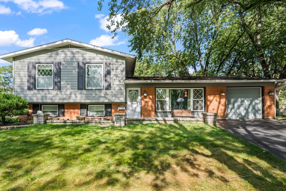
7979 Huntington Cir N Hanover Park, IL 60133
Estimated payment $2,384/month
Highlights
- Wood Flooring
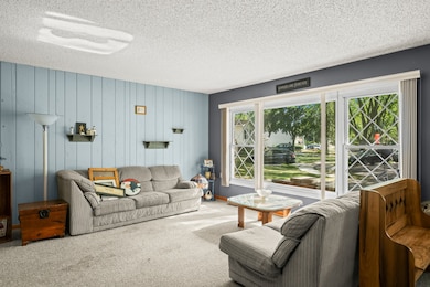
- Heated Sun or Florida Room
- Formal Dining Room
- Jane Addams Junior High School Rated A
- Lower Floor Utility Room
- Patio
About This Home
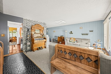
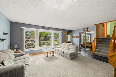
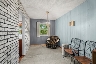
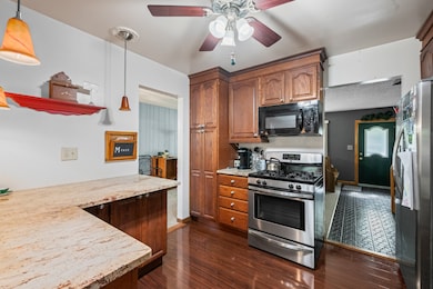
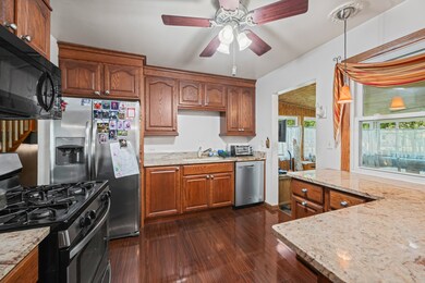
Welcome to this well-maintained 3-bedroom, 1.5-bath split-level home, perfectly situated on a quiet cul-de-sac. This charming property offers a functional layout with a bright kitchen featuring granite countertops and stainless steel appliances. Enjoy additional living space in the spacious four-season room-ideal for relaxing or entertaining year-round. The fenced yard provides privacy and includes a patio and storage shed for added convenience. A 1-car garage completes this cozy home. While the interior is somewhat outdated, it's clean, solid, and ready for a new owner to bring fresh ideas and make it their own. Don't miss this excellent opportunity to add your personal touch and create something special!
Listing Agent
Berkshire Hathaway HomeServices Starck Real Estate Brokerage Email: clientcare@starckre.com License #475148806 Listed on: 11/22/2025

Home Details
Home Type
- Single Family
Est. Annual Taxes
- $6,184
Year Built
- Built in 1969
Lot Details
- 8,276 Sq Ft Lot
- Lot Dimensions are 41x102x135x46x138
Parking
- 1 Car Garage
- Driveway
Home Design
- Split Level Home
- Brick Exterior Construction
- Asphalt Roof
- Concrete Perimeter Foundation
Interior Spaces
- 1,697 Sq Ft Home
- Ceiling Fan
- Family Room with Fireplace
- Living Room
- Formal Dining Room
- Heated Sun or Florida Room
- Lower Floor Utility Room
Kitchen
- Range
- Microwave
- Dishwasher
Flooring
- Wood
- Carpet
Bedrooms and Bathrooms
- 3 Bedrooms
- 3 Potential Bedrooms
Laundry
- Laundry Room
- Dryer
- Washer
Basement
- Basement Fills Entire Space Under The House
- Finished Basement Bathroom
Outdoor Features
- Patio
- Shed
Utilities
- Forced Air Heating and Cooling System
- Heating System Uses Natural Gas
- Gas Water Heater
Community Details
- Hanover Highlands Subdivision
Listing and Financial Details
- Senior Tax Exemptions
- Homeowner Tax Exemptions
Map
Home Values in the Area
Average Home Value in this Area
Tax History
| Year | Tax Paid | Tax Assessment Tax Assessment Total Assessment is a certain percentage of the fair market value that is determined by local assessors to be the total taxable value of land and additions on the property. | Land | Improvement |
|---|---|---|---|---|
| 2024 | $6,181 | $24,555 | $5,541 | $19,014 |
| 2023 | $5,921 | $25,552 | $5,541 | $20,011 |
| 2022 | $5,921 | $25,552 | $5,541 | $20,011 |
| 2021 | $4,649 | $19,142 | $3,622 | $15,520 |
| 2020 | $4,736 | $19,142 | $3,622 | $15,520 |
| 2019 | $4,813 | $21,508 | $3,622 | $17,886 |
| 2018 | $4,911 | $20,038 | $3,196 | $16,842 |
| 2017 | $3,147 | $20,038 | $3,196 | $16,842 |
| 2016 | $3,830 | $20,038 | $3,196 | $16,842 |
| 2015 | $4,354 | $16,764 | $2,770 | $13,994 |
| 2014 | $4,303 | $16,764 | $2,770 | $13,994 |
| 2013 | $4,140 | $16,764 | $2,770 | $13,994 |
Property History
| Date | Event | Price | List to Sale | Price per Sq Ft |
|---|---|---|---|---|
| 11/22/2025 11/22/25 | For Sale | $355,000 | -- | $209 / Sq Ft |
Purchase History
| Date | Type | Sale Price | Title Company |
|---|---|---|---|
| Deed | -- | -- |
Source: Midwest Real Estate Data (MRED)
MLS Number: 12522601
APN: 07-30-105-026-0000
Disclaimer: Certain information contained herein is derived from information provided by parties other than Homes.com. All information provided is deemed reliable, but is not guaranteed to be accurate and should be independently verified.
![]() Based on information submitted to the MLS GRID. All data is obtained from various sources and may not have been verified by broker or MLS GRID. Supplied Open House Information is subject to change without notice. All information should be independently reviewed and verified for accuracy. Properties may or may not be listed by the office/agent presenting the information. Some IDX listings have been excluded from this website.
Based on information submitted to the MLS GRID. All data is obtained from various sources and may not have been verified by broker or MLS GRID. Supplied Open House Information is subject to change without notice. All information should be independently reviewed and verified for accuracy. Properties may or may not be listed by the office/agent presenting the information. Some IDX listings have been excluded from this website.
The Digital Millennium Copyright Act of 1998, 17 U.S.C. § 512 (the “DMCA”) provides recourse for copyright owners who believe that material appearing on the Internet infringes their rights under U.S. copyright law. If you believe in good faith that any content or material made available in connection with our website or services infringes your copyright, you (or your agent) may send us a notice requesting that the content or material be removed, or access to it blocked.
Notices must be sent in writing by email to DMCAnotice@MLSGrid.com.
The DMCA requires that your notice of alleged copyright infringement include the following information:
(1) description of the copyrighted work that is the subject of claimed infringement;
(2) description of the alleged infringing content and information sufficient to permit us to locate the content;
(3) contact information for you, including your address, telephone number and email address;
(4) a statement by you that you have a good faith belief that the content in the manner complained of is not authorized by the copyright owner, or its agent, or by the operation of any law;
(5) a statement by you, signed under penalty of perjury, that the information in the notification is accurate and that you have the authority to enforce the copyrights that are claimed to be infringed; and
(6) a physical or electronic signature of the copyright owner or a person authorized to act on the copyright owner’s behalf. Failure to include all of the above information may result in the delay of the processing of your complaint.
- 8112 S Applewood Ct
- 7837 Huntington Cir S
- 7777 Ramsgate Cir S
- 1311 Kingsbury Dr Unit E
- 7526 Bristol Ln Unit 502
- 7544 Bristol Ln Unit 4
- 8181 Northway Dr
- 2450 Raleigh Ct Unit 2
- 209 Westminster Ct Unit C
- 2404 Baldwin Ct
- 7605 Manchester Manor
- 1914 Capital Ct
- 7418 Nantucket Cove
- 1930 W Weathersfield Way
- 1908 Capri Ln
- 224 Winnsboro Ct Unit A
- 216 Winnsboro Ct Unit A
- 1933 Whittier Ln
- 227 S Walnut Ln
- 2902 Belle Ln
- 1319 Kingsbury Dr Unit 2
- 7526 Bristol Ln Unit 502
- 1904 Winston Ln
- 257 Butternut Ln Unit 3A
- 55 King Dr
- 689 Wilson St
- 7463 Grant Cir
- 1910 Hollywood Ave
- 106 Dorshire Ct
- 97 N Walnut Ln
- 160 Stirling Ln Unit X1
- 7031 Glenwood Ln
- 1503 Mckool Ave
- 67 Beechmont Ct Unit W2
- 239 Camel Bend Ct Unit 4
- 283 Camel Bend Ct Unit 39283
- 307 Glasgow Ln Unit V2
- 1421 Carolina Ct
- 368 Glen Byrn Ct Unit 11368A
- 162 Stirling Ln