Estimated Value: $295,000 - $422,000
2
Beds
1
Bath
988
Sq Ft
$343/Sq Ft
Est. Value
About This Home
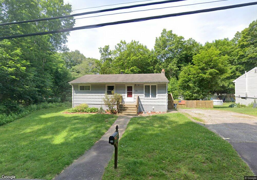
This home is located at 798 Hawthorne Ave, Derby, CT 06418 and is currently estimated at $339,015, approximately $343 per square foot. 798 Hawthorne Ave is a home located in New Haven County with nearby schools including Derby Middle School, Derby High School, and St Mary & St Michael School.
Ownership History
Date
Name
Owned For
Owner Type
Purchase Details
Closed on
Jan 9, 2019
Sold by
Masiak Michael
Bought by
Fanelli Matthew
Current Estimated Value
Home Financials for this Owner
Home Financials are based on the most recent Mortgage that was taken out on this home.
Original Mortgage
$131,400
Outstanding Balance
$115,992
Interest Rate
4.8%
Mortgage Type
Purchase Money Mortgage
Estimated Equity
$223,023
Purchase Details
Closed on
Sep 28, 1984
Bought by
Masiak Michael A
Create a Home Valuation Report for This Property
The Home Valuation Report is an in-depth analysis detailing your home's value as well as a comparison with similar homes in the area
Home Values in the Area
Average Home Value in this Area
Purchase History
| Date | Buyer | Sale Price | Title Company |
|---|---|---|---|
| Fanelli Matthew | $146,000 | -- | |
| Masiak Michael A | -- | -- |
Source: Public Records
Mortgage History
| Date | Status | Borrower | Loan Amount |
|---|---|---|---|
| Open | Masiak Michael A | $131,400 | |
| Previous Owner | Masiak Michael A | $50,000 |
Source: Public Records
Tax History Compared to Growth
Tax History
| Year | Tax Paid | Tax Assessment Tax Assessment Total Assessment is a certain percentage of the fair market value that is determined by local assessors to be the total taxable value of land and additions on the property. | Land | Improvement |
|---|---|---|---|---|
| 2025 | $5,210 | $120,610 | $38,210 | $82,400 |
| 2024 | $5,210 | $120,610 | $38,220 | $82,390 |
| 2023 | $4,656 | $120,610 | $38,220 | $82,390 |
| 2022 | $4,656 | $120,610 | $38,220 | $82,390 |
| 2021 | $4,656 | $120,610 | $38,220 | $82,390 |
| 2020 | $4,600 | $104,860 | $43,890 | $60,970 |
| 2019 | $4,390 | $104,860 | $43,890 | $60,970 |
| 2018 | $4,128 | $104,860 | $43,890 | $60,970 |
| 2017 | $4,128 | $104,860 | $43,890 | $60,970 |
| 2016 | $4,128 | $104,860 | $43,890 | $60,970 |
| 2015 | $3,783 | $105,840 | $43,890 | $61,950 |
| 2014 | $3,783 | $105,840 | $43,890 | $61,950 |
Source: Public Records
Map
Nearby Homes
- 16 Silver Hill Rd
- 2 Joyce Ave
- 3 McConney Grove
- 2 F St
- 60 E St
- 162 Emmett Ave
- 903 Howe Ave Unit 905
- 114 Emmett Ave
- 88 Summit St Unit 88
- 185 Wakelee Ave
- 193 Wakelee Ave
- 154 S Benham Rd
- 29 Great Hill Rd
- 194 Smith St
- 154 Hawthorne Ave
- 37 Foley Ave
- 17 Holbrook St
- 15 Holbrook St
- 13 Tomlinson St
- 42 Meadow St
- 870 Hawthorne Ave
- 17 Donna Ave
- 18 Joyce Ave
- 2 Derby Neck Rd
- 15 Donna Ave
- 0 Derby Neck Rd Unit N297917
- 0 Derby Neck Rd Unit B990100
- 0 Derby Neck Rd Unit 98450113
- 15 Joyce Ave
- 4 Derby Neck Rd
- 14 Donna Ave
- 16 Joyce Ave
- 4 Silver Hill Rd
- 8 Donna Ave
- 13 Donna Ave
- 6 Derby Neck Rd
- 11 Donna Ave
- 11 Donna Ave
- 14 Joyce Ave
- 13 Joyce Ave