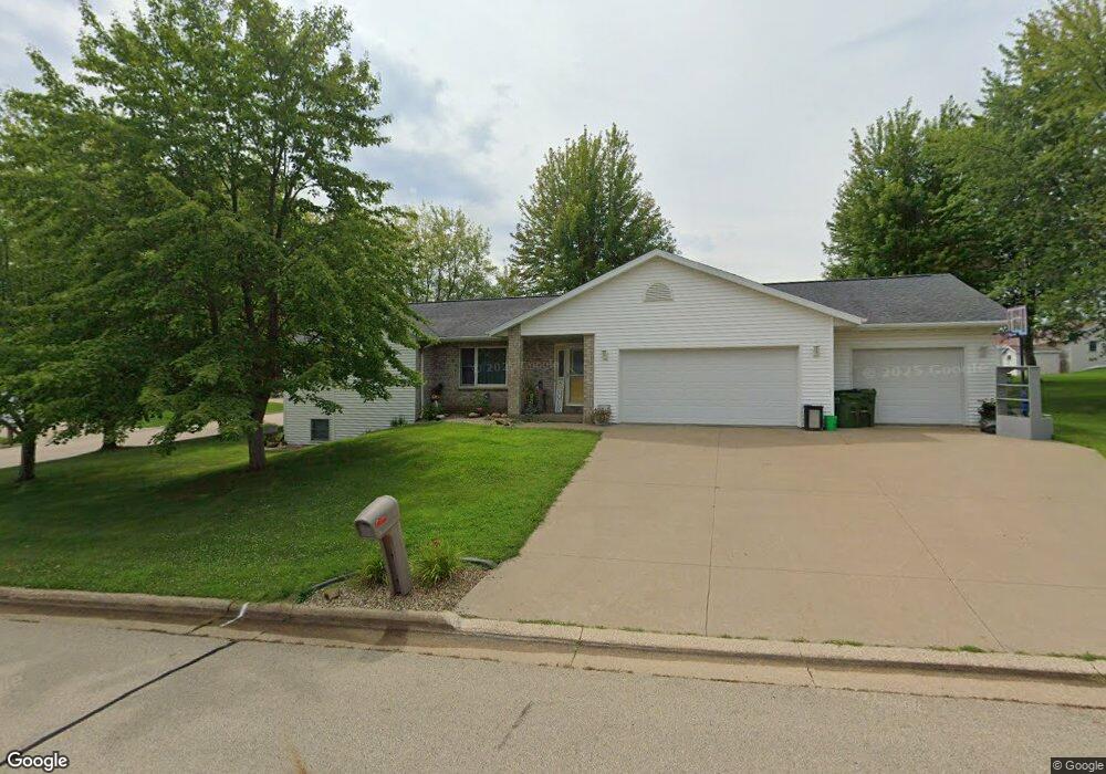
7986 Kalb Ridge St Peosta, IA 52068
Estimated Value: $357,000 - $427,000
3
Beds
3
Baths
1,499
Sq Ft
$258/Sq Ft
Est. Value
About This Home
This home is located at 7986 Kalb Ridge St, Peosta, IA 52068 and is currently estimated at $386,106, approximately $257 per square foot. 7986 Kalb Ridge St is a home located in Dubuque County with nearby schools including Peosta Elementary School, Drexler Middle - Intermediate School, and Western Dubuque High School.
Ownership History
Date
Name
Owned For
Owner Type
Purchase Details
Closed on
Jul 9, 2025
Sold by
Green Jerry Roy
Bought by
Green Rachel Renee
Current Estimated Value
Purchase Details
Closed on
Jul 18, 2019
Sold by
Freiburger Matthew J and Freiburger Jennifer L
Bought by
Green Jerry R and Green Rachel
Home Financials for this Owner
Home Financials are based on the most recent Mortgage that was taken out on this home.
Original Mortgage
$159,500
Interest Rate
3.82%
Mortgage Type
New Conventional
Create a Home Valuation Report for This Property
The Home Valuation Report is an in-depth analysis detailing your home's value as well as a comparison with similar homes in the area
Home Values in the Area
Average Home Value in this Area
Purchase History
| Date | Buyer | Sale Price | Title Company |
|---|---|---|---|
| Green Rachel Renee | -- | None Listed On Document | |
| Green Jerry R | $239,500 | None Available |
Source: Public Records
Mortgage History
| Date | Status | Borrower | Loan Amount |
|---|---|---|---|
| Previous Owner | Green Jerry R | $159,500 |
Source: Public Records
Tax History Compared to Growth
Tax History
| Year | Tax Paid | Tax Assessment Tax Assessment Total Assessment is a certain percentage of the fair market value that is determined by local assessors to be the total taxable value of land and additions on the property. | Land | Improvement |
|---|---|---|---|---|
| 2025 | $3,610 | $292,200 | $43,500 | $248,700 |
| 2024 | $3,610 | $271,200 | $43,500 | $227,700 |
| 2023 | $3,480 | $271,200 | $43,500 | $227,700 |
| 2022 | $3,110 | $217,650 | $43,500 | $174,150 |
| 2021 | $3,110 | $217,650 | $43,500 | $174,150 |
| 2020 | $2,976 | $200,800 | $39,150 | $161,650 |
| 2019 | $2,782 | $200,800 | $39,150 | $161,650 |
| 2018 | $2,726 | $187,640 | $27,670 | $159,970 |
| 2017 | $2,708 | $187,640 | $27,670 | $159,970 |
| 2016 | $2,674 | $178,930 | $26,100 | $152,830 |
| 2015 | $2,674 | $178,930 | $26,100 | $152,830 |
| 2014 | $2,674 | $172,810 | $26,100 | $146,710 |
Source: Public Records
Map
Nearby Homes
- 7630 Kaia Dr
- Lot 60 Hugo Dr
- Lot 64 Hugo Dr
- 175 Bryn Dr
- 419 Angela Jean Cir
- 9391 Cashel Dr E
- 8165 Hugo Dr
- 8202 Hugo Dr
- 8122 Hugo Dr
- 8166 Tegan Dr
- Lot 20 Ginger Dr
- Lot 90 Ginger Dr
- Lot 45 Gretel Ct
- 348 Solomia Ct
- 310 Solomia Ct
- 326 Solomia Ct
- Lot 29 Ginger Dr
- Lot 28 Ginger Dr
- Lot 25 Ginger Dr
- Lot 24 Ginger Dr
- 633 Willow Ridge S
- 633 Willow Ridge S
- 652 Birch Ridge S
- 7985 Kalb Ridge St
- 634 Birch Ridge S
- 625 Willow Ridge S
- 652 Willow Ridge S
- 682 Birch Ridge N
- 634 Willow Ridge S
- 628 Birch Ridge S
- 701 Willow Ridge N
- 682 Willow Ridge S
- 628 Willow Ridge S
- 603 Willow Ridge S
- 700 Birch Ridge N
- 700 Willow Ridge N
- 602 Birch Ridge S
- 715 Willow Ridge N
- 602 Willow Ridge S
- 649 Birch Ridge N