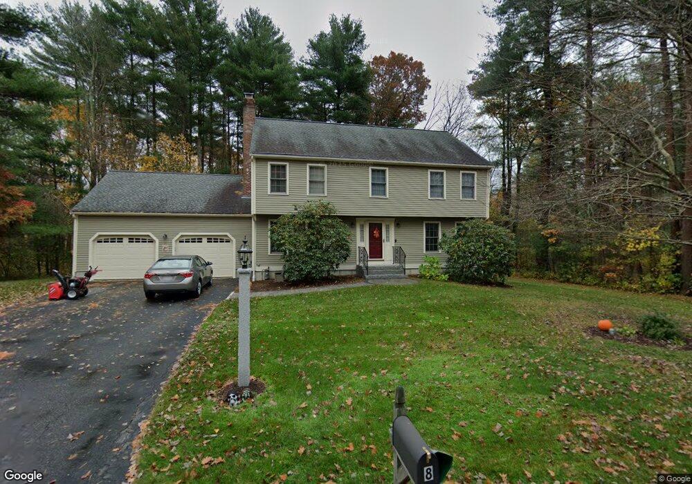
8 Forest Rd Medway, MA 02053
Estimated Value: $793,617 - $939,000
4
Beds
3
Baths
2,560
Sq Ft
$338/Sq Ft
Est. Value
About This Home
This home is located at 8 Forest Rd, Medway, MA 02053 and is currently estimated at $865,404, approximately $338 per square foot. 8 Forest Rd is a home located in Norfolk County with nearby schools including John D. McGovern Elementary School, Burke-Memorial Elementary, and Medway Middle School.
Ownership History
Date
Name
Owned For
Owner Type
Purchase Details
Closed on
Dec 3, 2019
Sold by
Muratori Donald R and Muratori Patricia A
Bought by
Muratori Lt
Current Estimated Value
Purchase Details
Closed on
Apr 15, 1992
Sold by
Coras Tr Gregory J
Bought by
Muratori Donald R and Muratori Patricia A
Home Financials for this Owner
Home Financials are based on the most recent Mortgage that was taken out on this home.
Original Mortgage
$170,000
Interest Rate
8.75%
Mortgage Type
Purchase Money Mortgage
Create a Home Valuation Report for This Property
The Home Valuation Report is an in-depth analysis detailing your home's value as well as a comparison with similar homes in the area
Home Values in the Area
Average Home Value in this Area
Purchase History
| Date | Buyer | Sale Price | Title Company |
|---|---|---|---|
| Muratori Lt | -- | None Available | |
| Muratori Donald R | $216,000 | -- |
Source: Public Records
Mortgage History
| Date | Status | Borrower | Loan Amount |
|---|---|---|---|
| Previous Owner | Muratori Donald R | $167,000 | |
| Previous Owner | Muratori Donald R | $170,000 |
Source: Public Records
Tax History Compared to Growth
Tax History
| Year | Tax Paid | Tax Assessment Tax Assessment Total Assessment is a certain percentage of the fair market value that is determined by local assessors to be the total taxable value of land and additions on the property. | Land | Improvement |
|---|---|---|---|---|
| 2025 | $9,767 | $685,400 | $342,500 | $342,900 |
| 2024 | $9,870 | $685,400 | $342,500 | $342,900 |
| 2023 | $9,829 | $616,600 | $312,000 | $304,600 |
| 2022 | $10,076 | $519,000 | $231,400 | $287,600 |
| 2021 | $8,789 | $503,400 | $216,100 | $287,300 |
| 2020 | $8,579 | $490,200 | $216,100 | $274,100 |
| 2019 | $8,098 | $477,200 | $207,400 | $269,800 |
| 2018 | $8,157 | $461,900 | $198,700 | $263,200 |
| 2017 | $8,105 | $452,300 | $194,400 | $257,900 |
| 2016 | $7,914 | $437,000 | $179,100 | $257,900 |
| 2015 | $7,850 | $430,400 | $176,900 | $253,500 |
| 2014 | $7,679 | $407,600 | $179,600 | $228,000 |
Source: Public Records
Map
Nearby Homes
- 280 Village St Unit D2
- 5 Richardson St
- 4 Shaw St
- 10 Prospect St
- 176 Main St Unit 3
- 21 Riverside Rd
- 14 Heritage Dr
- 0 Elm St
- 220 Main St Unit 220
- 14 Sanford St Unit 15
- 20 Broad St Unit 6
- 20 Broad St Unit A
- 20 Broad St Unit 4
- 5 Fales St
- 3 Meryl St
- 9 Sanford St
- 7 Gloucester Dr
- 12 Lovering St
- 36 Lovering St
- 841 Lincoln St