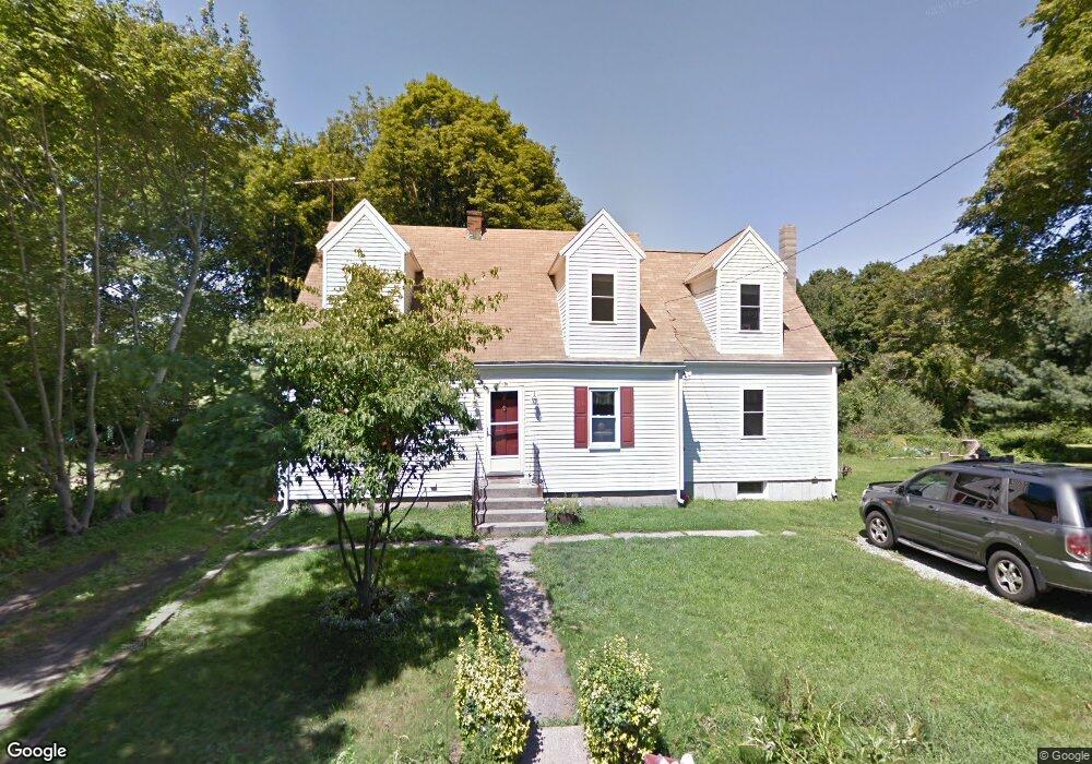
8 Gee Ave Gloucester, MA 01930
Estimated Value: $638,000 - $800,000
4
Beds
3
Baths
2,240
Sq Ft
$329/Sq Ft
Est. Value
About This Home
This home is located at 8 Gee Ave, Gloucester, MA 01930 and is currently estimated at $736,897, approximately $328 per square foot. 8 Gee Ave is a home located in Essex County with nearby schools including Beeman Memorial, Ralph B O'maley Middle School, and Gloucester High School.
Ownership History
Date
Name
Owned For
Owner Type
Purchase Details
Closed on
Nov 15, 2004
Sold by
Ketchopulos Sean A and Ketchopulos Shelby L
Bought by
Ketchopulos Sean A
Current Estimated Value
Purchase Details
Closed on
Feb 20, 2001
Sold by
Mello Avis Rebecca Est
Bought by
Ketchopulos Sean A and Ketchopulos Shelby L
Create a Home Valuation Report for This Property
The Home Valuation Report is an in-depth analysis detailing your home's value as well as a comparison with similar homes in the area
Purchase History
| Date | Buyer | Sale Price | Title Company |
|---|---|---|---|
| Ketchopulos Sean A | -- | -- | |
| Ketchopulos Sean A | $205,000 | -- |
Source: Public Records
Mortgage History
| Date | Status | Borrower | Loan Amount |
|---|---|---|---|
| Open | Ketchopulos Sean A | $281,300 | |
| Closed | Ketchopulos Sean A | $25,000 | |
| Closed | Ketchopulos Sean A | $284,000 |
Source: Public Records
Tax History
| Year | Tax Paid | Tax Assessment Tax Assessment Total Assessment is a certain percentage of the fair market value that is determined by local assessors to be the total taxable value of land and additions on the property. | Land | Improvement |
|---|---|---|---|---|
| 2025 | $6,132 | $630,900 | $187,300 | $443,600 |
| 2024 | $6,184 | $635,600 | $178,400 | $457,200 |
| 2023 | $5,990 | $565,600 | $159,300 | $406,300 |
| 2022 | $5,396 | $460,000 | $138,500 | $321,500 |
| 2021 | $5,460 | $438,900 | $125,900 | $313,000 |
| 2020 | $5,255 | $426,200 | $125,900 | $300,300 |
| 2019 | $5,226 | $411,800 | $125,900 | $285,900 |
| 2018 | $5,137 | $397,300 | $125,900 | $271,400 |
| 2017 | $4,925 | $373,400 | $119,900 | $253,500 |
| 2016 | $5,096 | $374,400 | $139,000 | $235,400 |
| 2015 | $4,858 | $355,900 | $139,000 | $216,900 |
Source: Public Records
Map
Nearby Homes
- 3 Deacon Farm Ln
- 31 Echo Ave
- 2 Breezy Point Rd
- 13 Honeysuckle Rd
- 672 Washington St
- 13 Mystic Ave
- 8 Mystic Ave
- 6 Monroe Ct
- 98 Maplewood Ave
- 167 Atlantic St
- 178 Atlantic St
- 12 Arthur St
- 9 Cleveland Place
- 40 Sargent St
- 226 Atlantic St
- 19 Trask St Unit 2
- 50 Warner St
- 113 Pleasant St
- 33 Maplewood Ave Unit 310
- 15 Harvard St
Your Personal Tour Guide
Ask me questions while you tour the home.