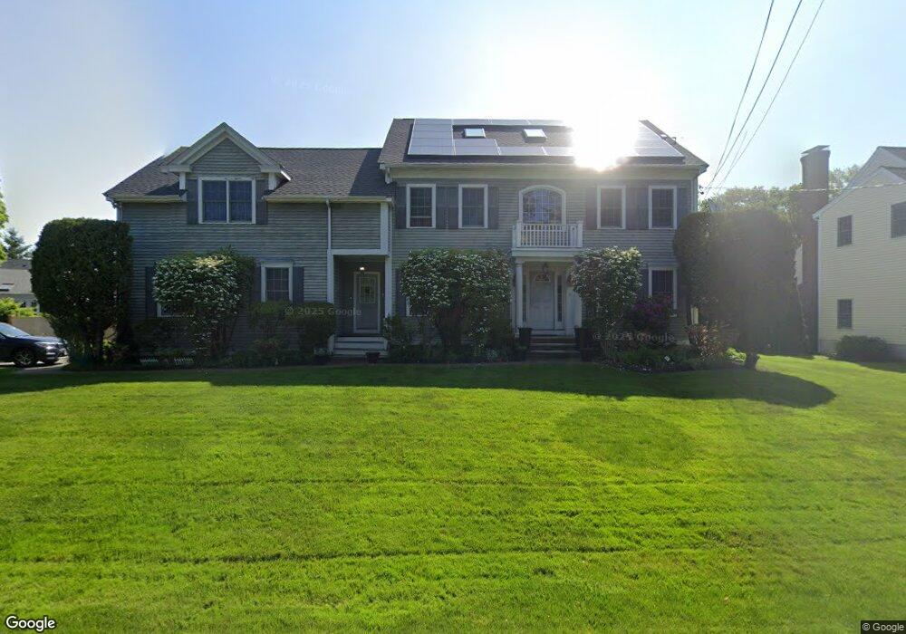
8 Harland St Milton, MA 02186
Brush Hill NeighborhoodEstimated Value: $1,823,598 - $2,025,000
4
Beds
4
Baths
3,626
Sq Ft
$531/Sq Ft
Est. Value
About This Home
This home is located at 8 Harland St, Milton, MA 02186 and is currently estimated at $1,924,150, approximately $530 per square foot. 8 Harland St is a home located in Norfolk County with nearby schools including Milton High School, Delphi Academy of Boston, and St. Mary of the Hills School.
Ownership History
Date
Name
Owned For
Owner Type
Purchase Details
Closed on
Sep 20, 2024
Sold by
Daly Caroleen L
Bought by
Daly Ft and Daly
Current Estimated Value
Purchase Details
Closed on
Aug 2, 2002
Sold by
Mccarthy Robert D
Bought by
Harland St Nt
Home Financials for this Owner
Home Financials are based on the most recent Mortgage that was taken out on this home.
Original Mortgage
$430,000
Interest Rate
6.64%
Mortgage Type
Purchase Money Mortgage
Create a Home Valuation Report for This Property
The Home Valuation Report is an in-depth analysis detailing your home's value as well as a comparison with similar homes in the area
Home Values in the Area
Average Home Value in this Area
Purchase History
| Date | Buyer | Sale Price | Title Company |
|---|---|---|---|
| Daly Ft | -- | None Available | |
| Daly Ft | -- | None Available | |
| Harland St Nt | $250,000 | -- | |
| Harland St Nt | $250,000 | -- |
Source: Public Records
Mortgage History
| Date | Status | Borrower | Loan Amount |
|---|---|---|---|
| Previous Owner | Harland St Nt | $430,000 |
Source: Public Records
Tax History Compared to Growth
Tax History
| Year | Tax Paid | Tax Assessment Tax Assessment Total Assessment is a certain percentage of the fair market value that is determined by local assessors to be the total taxable value of land and additions on the property. | Land | Improvement |
|---|---|---|---|---|
| 2025 | $16,081 | $1,450,000 | $537,900 | $912,100 |
| 2024 | $15,622 | $1,430,600 | $512,200 | $918,400 |
| 2023 | $15,271 | $1,339,600 | $487,900 | $851,700 |
| 2022 | $14,402 | $1,154,900 | $487,900 | $667,000 |
| 2021 | $14,317 | $1,090,400 | $446,600 | $643,800 |
| 2020 | $14,079 | $1,073,100 | $438,200 | $634,900 |
| 2019 | $13,731 | $1,041,800 | $425,400 | $616,400 |
| 2018 | $13,028 | $943,400 | $331,400 | $612,000 |
| 2017 | $12,200 | $899,700 | $315,600 | $584,100 |
| 2016 | $11,703 | $866,900 | $315,600 | $551,300 |
| 2015 | $11,757 | $843,400 | $290,700 | $552,700 |
Source: Public Records
Map
Nearby Homes
- 7 Preacher Rd
- 485 Blue Hills Pkwy Unit 11
- 485 Blue Hills Pkwy Unit 27
- 485 Blue Hills Pkwy Unit 38
- 485 Blue Hills Pkwy Unit 6
- 485 Blue Hills Pkwy Unit 21
- 485 Blue Hills Pkwy Unit 44
- 485 Blue Hills Pkwy Unit 23
- 485 Blue Hills Pkwy Unit 20
- 485 Blue Hills Pkwy Unit 26
- 485 Blue Hills Pkwy Unit 28
- 485 Blue Hills Pkwy Unit 2
- 485 Blue Hills Pkwy Unit 33
- 200 Robbins St
- 350 Blue Hill Ave
- 40 Lafayette St
- 375 Atherton St
- 723 Blue Hill Ave
- 405 Blue Hill Ave
- 589 Brush Hill Rd