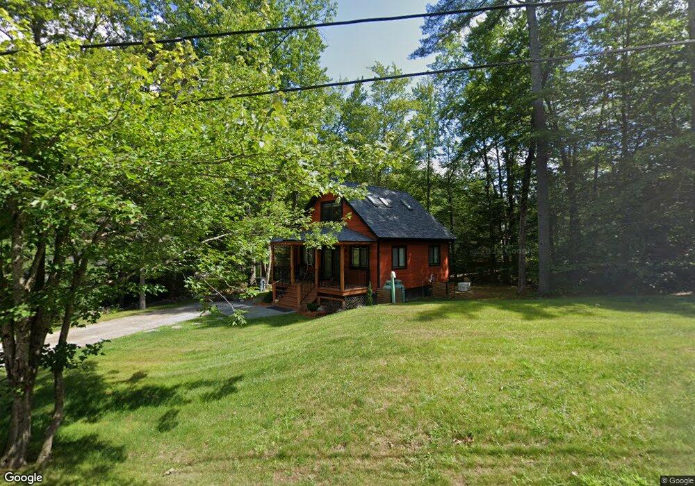
8 Hector Ln Bristol, NH 03222
Estimated Value: $377,000 - $528,000
3
Beds
2
Baths
1,397
Sq Ft
$313/Sq Ft
Est. Value
About This Home
This home is located at 8 Hector Ln, Bristol, NH 03222 and is currently estimated at $437,540, approximately $313 per square foot. 8 Hector Ln is a home.
Ownership History
Date
Name
Owned For
Owner Type
Purchase Details
Closed on
Oct 19, 2023
Sold by
Lavallee Paul B and Lavallee Wendy M
Bought by
Hector Lane Llc
Current Estimated Value
Purchase Details
Closed on
Jul 7, 2023
Sold by
A F T C
Bought by
Lavallee Paul B and Lavallee Wendy M
Home Financials for this Owner
Home Financials are based on the most recent Mortgage that was taken out on this home.
Original Mortgage
$247,500
Interest Rate
6.57%
Mortgage Type
Purchase Money Mortgage
Purchase Details
Closed on
Dec 10, 2019
Sold by
Fay Carol A
Bought by
Caf T
Create a Home Valuation Report for This Property
The Home Valuation Report is an in-depth analysis detailing your home's value as well as a comparison with similar homes in the area
Home Values in the Area
Average Home Value in this Area
Purchase History
| Date | Buyer | Sale Price | Title Company |
|---|---|---|---|
| Hector Lane Llc | -- | None Available | |
| Lavallee Paul B | $330,000 | None Available | |
| Lavallee Paul B | $330,000 | None Available | |
| Caf T | -- | None Available |
Source: Public Records
Mortgage History
| Date | Status | Borrower | Loan Amount |
|---|---|---|---|
| Previous Owner | Lavallee Paul B | $247,500 |
Source: Public Records
Tax History Compared to Growth
Tax History
| Year | Tax Paid | Tax Assessment Tax Assessment Total Assessment is a certain percentage of the fair market value that is determined by local assessors to be the total taxable value of land and additions on the property. | Land | Improvement |
|---|---|---|---|---|
| 2024 | $3,874 | $164,000 | $119,400 | $44,600 |
| 2023 | $3,731 | $164,000 | $119,400 | $44,600 |
| 2022 | $4,139 | $197,200 | $119,400 | $77,800 |
| 2021 | $3,985 | $197,200 | $119,400 | $77,800 |
| 2020 | $4,080 | $197,200 | $119,400 | $77,800 |
| 2019 | $3,963 | $173,800 | $99,000 | $74,800 |
| 2018 | $3,789 | $173,800 | $99,000 | $74,800 |
| 2017 | $3,846 | $173,800 | $99,000 | $74,800 |
| 2016 | $3,584 | $173,800 | $99,000 | $74,800 |
| 2015 | $3,813 | $189,400 | $109,000 | $80,400 |
| 2014 | $3,813 | $189,400 | $109,000 | $80,400 |
| 2013 | $3,822 | $189,400 | $109,000 | $80,400 |
Source: Public Records
Map
Nearby Homes
- 383 Wulamat Rd
- 35 Manor Estates Dr Unit 14
- 40 Adams Rd
- 26 Don Gerry Rd
- 199 Cottage City Rd
- 114 Ledgewood Terrace
- 125 Verrill Rd
- 94 Mandi Ln
- 862 Mayhew Turnpike Unit 1
- 29 Daniels Rd
- Lot 7 Hall Rd
- 333 Lake St
- 4 Birchwood Dr Unit A
- 301 Perkins Hill Rd
- 00 Ledgewood Cir Unit 7
- 497 W Shore Rd
- 80 Patten Rd
- 341 Perkins Hill Rd
- 135 Pleasant St
- 150 Peaked Hill Rd