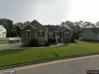
8 Hollingsworth Way Poquoson, VA 23662
Poquoson Shores NeighborhoodEstimated Value: $562,746 - $623,000
4
Beds
4
Baths
2,850
Sq Ft
$210/Sq Ft
Est. Value
About This Home
This home is located at 8 Hollingsworth Way, Poquoson, VA 23662 and is currently estimated at $598,687, approximately $210 per square foot. 8 Hollingsworth Way is a home located in Poquoson City with nearby schools including Summit Christian Academy - Upper School.
Ownership History
Date
Name
Owned For
Owner Type
Purchase Details
Closed on
May 10, 2017
Sold by
Sarfan Randall E
Bought by
Simpson Brandon
Current Estimated Value
Home Financials for this Owner
Home Financials are based on the most recent Mortgage that was taken out on this home.
Original Mortgage
$279,000
Interest Rate
4.14%
Mortgage Type
Construction
Purchase Details
Closed on
Oct 26, 2010
Sold by
Lannetti Sub Tr David W
Bought by
Sarfan Randall E
Create a Home Valuation Report for This Property
The Home Valuation Report is an in-depth analysis detailing your home's value as well as a comparison with similar homes in the area
Home Values in the Area
Average Home Value in this Area
Purchase History
| Date | Buyer | Sale Price | Title Company |
|---|---|---|---|
| Simpson Brandon | $100,000 | Title Quest | |
| Sarfan Randall E | $370,000 | -- |
Source: Public Records
Mortgage History
| Date | Status | Borrower | Loan Amount |
|---|---|---|---|
| Open | Donkel Rickey Paul | $409,500 | |
| Closed | Donkel Rickey P | $422,300 | |
| Closed | Simpson Brandon | $279,000 |
Source: Public Records
Tax History Compared to Growth
Tax History
| Year | Tax Paid | Tax Assessment Tax Assessment Total Assessment is a certain percentage of the fair market value that is determined by local assessors to be the total taxable value of land and additions on the property. | Land | Improvement |
|---|---|---|---|---|
| 2024 | $5,764 | $505,600 | $110,900 | $394,700 |
| 2023 | $5,612 | $505,600 | $110,900 | $394,700 |
| 2022 | $5,247 | $464,300 | $110,900 | $353,400 |
| 2021 | $5,100 | $451,300 | $110,900 | $340,400 |
| 2020 | -- | $413,800 | $110,900 | $302,900 |
| 2019 | -- | $413,800 | $110,900 | $302,900 |
| 2018 | -- | $411,800 | $110,900 | $300,900 |
| 2017 | -- | $110,900 | $110,900 | $0 |
| 2016 | -- | $110,900 | $110,900 | $0 |
| 2015 | -- | $107,600 | $107,600 | $0 |
| 2013 | -- | $107,600 | $107,600 | $0 |
Source: Public Records
Map
Nearby Homes
- 2 Hollingsworth Way
- 5 Bessies Landing Dr
- 89 Sandy Bay Dr
- 28 Pasture Rd
- 15+AC Browns Neck Rd
- 21 Bayview Dr
- 105 Rens Rd Unit 2
- 105 Rens Rd Unit Lot 48
- 105 Rens Rd Unit Lot 36
- 105 Rens Rd Unit 74
- 20 Ferguson St
- 102 Blue Crab Dr
- 100 Blue Crab Dr
- 6 Lessies Dr
- 31 Kelsor Dr
- 103 Darden Dr
- 50 W Wainwright Dr
- 720 Poquoson Ave
- 15 Pickins Dr
- 127 Freemoor Dr
- 8 Hollingsworth Way
- 6 Hollingsworth Way
- 10 Hollingsworth Way
- 9 Hollingsworth Way
- 7 Hollingsworth Way
- 12 Hollingsworth Way
- 4 Hollingsworth Way
- 11 Hollingsworth Way
- 173 Beach Rd
- 191 Beach Rd
- 193 Beach Rd
- Lot 2 Printers Alley
- 171 Beach Rd
- 8 Moore Rd
- 30 Moore Rd
- 141 Pasture Rd
- 32 Moore Rd
- 153 Pasture Rd
- 6 Moore Rd
- 195 Beach Rd