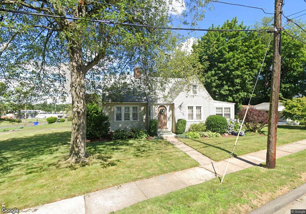
8 Lindbergh Dr Wethersfield, CT 06109
Estimated Value: $412,000 - $450,000
3
Beds
2
Baths
1,769
Sq Ft
$240/Sq Ft
Est. Value
About This Home
This home is located at 8 Lindbergh Dr, Wethersfield, CT 06109 and is currently estimated at $424,533, approximately $239 per square foot. 8 Lindbergh Dr is a home located in Hartford County with nearby schools including Charles Wright School, Silas Deane Middle School, and Wethersfield High School.
Ownership History
Date
Name
Owned For
Owner Type
Purchase Details
Closed on
Oct 20, 2011
Sold by
Kinney Robert
Bought by
Thompson Henry S
Current Estimated Value
Purchase Details
Closed on
Oct 28, 2010
Sold by
Rell Michael L
Bought by
Wengzn Joanne G
Home Financials for this Owner
Home Financials are based on the most recent Mortgage that was taken out on this home.
Original Mortgage
$182,500
Interest Rate
4.39%
Purchase Details
Closed on
Jul 16, 2004
Sold by
Elliott David L and Elliott Margaret Pasbac
Bought by
Rell Michael L
Home Financials for this Owner
Home Financials are based on the most recent Mortgage that was taken out on this home.
Original Mortgage
$234,800
Interest Rate
6.25%
Purchase Details
Closed on
May 1, 2002
Sold by
Keane Timothy E and Keane Heatherk
Bought by
Elliott David D and Pasbach Magaret
Create a Home Valuation Report for This Property
The Home Valuation Report is an in-depth analysis detailing your home's value as well as a comparison with similar homes in the area
Home Values in the Area
Average Home Value in this Area
Purchase History
| Date | Buyer | Sale Price | Title Company |
|---|---|---|---|
| Thompson Henry S | $85,000 | -- | |
| Wengzn Joanne G | $234,500 | -- | |
| Rell Michael L | $237,000 | -- | |
| Elliott David D | $183,500 | -- |
Source: Public Records
Mortgage History
| Date | Status | Borrower | Loan Amount |
|---|---|---|---|
| Previous Owner | Elliott David D | $182,500 | |
| Previous Owner | Elliott David D | $234,800 | |
| Previous Owner | Elliott David D | $3,500 |
Source: Public Records
Tax History
| Year | Tax Paid | Tax Assessment Tax Assessment Total Assessment is a certain percentage of the fair market value that is determined by local assessors to be the total taxable value of land and additions on the property. | Land | Improvement |
|---|---|---|---|---|
| 2025 | $9,882 | $239,740 | $91,920 | $147,820 |
| 2024 | $6,658 | $154,050 | $65,100 | $88,950 |
| 2023 | $6,439 | $154,120 | $65,100 | $89,020 |
| 2022 | $6,331 | $154,120 | $65,100 | $89,020 |
| 2021 | $6,268 | $154,120 | $65,100 | $89,020 |
| 2020 | $6,271 | $154,120 | $65,100 | $89,020 |
| 2019 | $6,279 | $154,120 | $65,100 | $89,020 |
| 2018 | $6,394 | $156,800 | $62,500 | $94,300 |
| 2017 | $6,236 | $156,800 | $62,500 | $94,300 |
| 2016 | $6,043 | $156,800 | $62,500 | $94,300 |
| 2015 | $5,988 | $156,800 | $62,500 | $94,300 |
| 2014 | $5,761 | $156,800 | $62,500 | $94,300 |
Source: Public Records
Map
Nearby Homes
- 35 Stillwold Dr
- 108 Chamberlain Rd
- 91 Somerset St
- 87 Somerset St
- 119 Coleman Rd
- 137 Dale Rd
- 195 Middletown Ave
- 38 Wheeler Rd
- 116 Wells Farm Dr
- 455 Brimfield Rd
- 89 Merriman Rd
- 18 Avalon Place
- 493 Main St
- 219 Jordan Ln Unit 221
- 97 Brussels Ave
- 104 Willow St
- 20 Forest Dr
- 47 Forest Dr
- 19 Albert Ave
- 90 Goodwin Park Rd
Your Personal Tour Guide
Ask me questions while you tour the home.