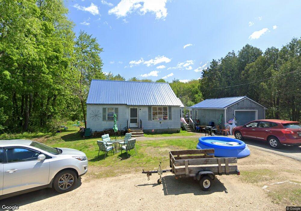
8 Tates Brook Rd Somersworth, NH 03878
Estimated Value: $296,000 - $374,000
3
Beds
2
Baths
1,190
Sq Ft
$296/Sq Ft
Est. Value
About This Home
This home is located at 8 Tates Brook Rd, Somersworth, NH 03878 and is currently estimated at $352,662, approximately $296 per square foot. 8 Tates Brook Rd is a home with nearby schools including Maple Wood Elementary School, Somersworth High School, and Tri-City Christian Academy.
Ownership History
Date
Name
Owned For
Owner Type
Purchase Details
Closed on
Sep 8, 2025
Sold by
Edgar Paul T and Edgar Susan D
Bought by
Castro John P and Castro Carol A
Current Estimated Value
Home Financials for this Owner
Home Financials are based on the most recent Mortgage that was taken out on this home.
Original Mortgage
$283,765
Outstanding Balance
$283,274
Interest Rate
6.74%
Mortgage Type
FHA
Estimated Equity
$69,388
Purchase Details
Closed on
Feb 22, 2005
Sold by
Nay Marshall A and Nay Ethel M
Bought by
Edgar Paul T and Edgar Susan D
Home Financials for this Owner
Home Financials are based on the most recent Mortgage that was taken out on this home.
Original Mortgage
$140,000
Interest Rate
5.78%
Mortgage Type
Purchase Money Mortgage
Purchase Details
Closed on
Sep 17, 1998
Sold by
Melanson David T and Melanson Janet A
Bought by
Nay Marshal A and Nay Etel M
Create a Home Valuation Report for This Property
The Home Valuation Report is an in-depth analysis detailing your home's value as well as a comparison with similar homes in the area
Home Values in the Area
Average Home Value in this Area
Purchase History
| Date | Buyer | Sale Price | Title Company |
|---|---|---|---|
| Castro John P | $289,000 | -- | |
| Castro John P | $289,000 | -- | |
| Edgar Paul T | $200,000 | -- | |
| Edgar Paul T | $200,000 | -- | |
| Nay Marshal A | $87,900 | -- | |
| Nay Marshal A | $87,900 | -- |
Source: Public Records
Mortgage History
| Date | Status | Borrower | Loan Amount |
|---|---|---|---|
| Open | Castro John P | $283,765 | |
| Closed | Castro John P | $283,765 | |
| Previous Owner | Nay Marshal A | $139,000 | |
| Previous Owner | Nay Marshal A | $140,000 |
Source: Public Records
Tax History Compared to Growth
Tax History
| Year | Tax Paid | Tax Assessment Tax Assessment Total Assessment is a certain percentage of the fair market value that is determined by local assessors to be the total taxable value of land and additions on the property. | Land | Improvement |
|---|---|---|---|---|
| 2024 | $5,337 | $285,400 | $41,800 | $243,600 |
| 2023 | $6,039 | $206,100 | $40,500 | $165,600 |
| 2022 | $5,772 | $205,500 | $40,500 | $165,000 |
| 2021 | $5,663 | $205,700 | $40,500 | $165,200 |
| 2020 | $5,698 | $205,700 | $40,500 | $165,200 |
| 2019 | $5,611 | $205,700 | $40,500 | $165,200 |
| 2018 | $5,382 | $161,100 | $46,600 | $114,500 |
| 2017 | $5,337 | $161,300 | $46,600 | $114,700 |
| 2016 | $5,181 | $161,300 | $46,600 | $114,700 |
| 2015 | $5,202 | $161,300 | $46,600 | $114,700 |
| 2014 | $5,023 | $161,300 | $46,600 | $114,700 |
Source: Public Records
Map
Nearby Homes
- 159 W High St
- 43 Otis Rd
- 18 Lenox Dr Unit C
- 203 New Hampshire 108
- 29 Chadwick Ln
- 19B Birch Hill Ln Unit 19B
- 13 Guy St
- 23A Birch Hill Ln Unit 23A
- 23B Birch Hill Ln Unit 23B
- 22A Birch Hill Ln Unit 22A
- 19A Birch Hill Ln Unit 19A
- 27B Birch Hill Ln Unit 27B
- 22B Birch Hill Ln Unit 22B
- 395 Route 108
- 23 Mount Vernon St
- 18 Grand St
- 178 High St
- 24-26 Highland St
- 163 Rochester St
- 301 Sherwood Glen
- 39 Pinewood Dr
- 11 Tates Brook Rd
- 14 Tates Brook Rd
- 15 Tates Brook Rd
- 137 W High St
- 16 Tates Brook Rd
- 17 Tates Brook Rd
- 10 Tates Brook Rd
- 18 Tates Brook Rd
- 1 Otis Rd
- 19 Tates Brook Rd
- 2 Otis Rd
- 3 Otis Rd
- 20 Tates Brook Rd
- 21 Tates Brook Rd
- 22 Tates Brook Rd
- 147 W High St
- 15 Otis Rd
- 154 W High St
- 151 W High St