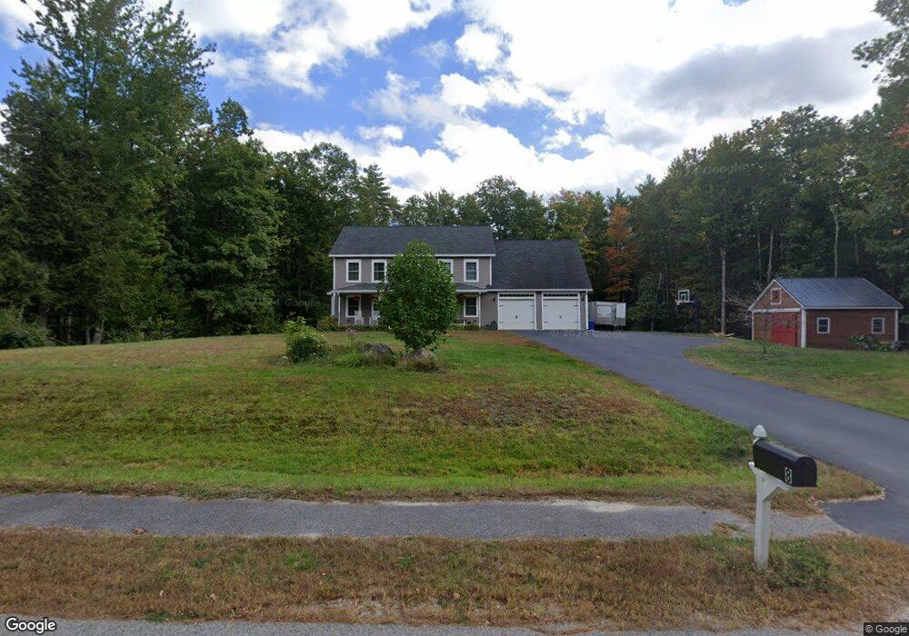
8 Westbranch Rd Cumberland Center, ME 04021
West Cumberland NeighborhoodEstimated Value: $882,204 - $1,058,000
3
Beds
3
Baths
2,784
Sq Ft
$336/Sq Ft
Est. Value
About This Home
This home is located at 8 Westbranch Rd, Cumberland Center, ME 04021 and is currently estimated at $935,551, approximately $336 per square foot. 8 Westbranch Rd is a home with nearby schools including Mabel I. Wilson School, Greely Middle School 4-5, and Greely Middle School.
Ownership History
Date
Name
Owned For
Owner Type
Purchase Details
Closed on
Apr 1, 2013
Sold by
Chase Custom Hms & Fin Inc
Bought by
Brown Jason M and Brown Jessica P
Current Estimated Value
Home Financials for this Owner
Home Financials are based on the most recent Mortgage that was taken out on this home.
Original Mortgage
$341,982
Outstanding Balance
$240,716
Interest Rate
3.56%
Mortgage Type
New Conventional
Estimated Equity
$694,835
Create a Home Valuation Report for This Property
The Home Valuation Report is an in-depth analysis detailing your home's value as well as a comparison with similar homes in the area
Home Values in the Area
Average Home Value in this Area
Purchase History
| Date | Buyer | Sale Price | Title Company |
|---|---|---|---|
| Brown Jason M | -- | -- | |
| Brown Jason M | -- | -- | |
| Brown Jason M | -- | -- |
Source: Public Records
Mortgage History
| Date | Status | Borrower | Loan Amount |
|---|---|---|---|
| Open | Brown Jason M | $341,982 | |
| Closed | Brown Jason M | $341,982 |
Source: Public Records
Tax History Compared to Growth
Tax History
| Year | Tax Paid | Tax Assessment Tax Assessment Total Assessment is a certain percentage of the fair market value that is determined by local assessors to be the total taxable value of land and additions on the property. | Land | Improvement |
|---|---|---|---|---|
| 2025 | $11,069 | $439,600 | $171,200 | $268,400 |
| 2024 | $10,039 | $431,800 | $171,200 | $260,600 |
| 2023 | $9,564 | $431,800 | $171,200 | $260,600 |
| 2022 | $9,027 | $425,800 | $171,200 | $254,600 |
| 2021 | $8,750 | $425,800 | $171,200 | $254,600 |
| 2020 | $8,665 | $425,800 | $171,200 | $254,600 |
| 2019 | $8,452 | $425,800 | $171,200 | $254,600 |
| 2018 | $8,242 | $418,400 | $171,200 | $247,200 |
| 2017 | $7,832 | $416,600 | $171,200 | $245,400 |
| 2016 | $7,603 | $416,600 | $171,200 | $245,400 |
| 2015 | $7,171 | $396,200 | $171,200 | $225,000 |
| 2014 | $6,894 | $396,200 | $171,200 | $225,000 |
| 2013 | $6,735 | $396,200 | $171,200 | $225,000 |
Source: Public Records
Map
Nearby Homes
- 63 Peaceful Way
- 43 Skillin Rd
- 5 Skillin Rd
- 0 Thomes Way
- 8 Summer Way
- 8 Castle Rock
- 8 Feldspar Ln Unit 29
- 7 Castle Rock Dr
- 5 Feldspar Ln Unit 3
- 1 Feldspar Ln Unit 1
- 27 Feldspar Ln Unit 14
- 24 Feldspar Ln Unit 23
- 25 Feldspar Ln Unit 13
- 13 Feldspar Ln Unit 7
- 30 Feldspar Ln Unit 21
- 21 Feldspar Ln Unit 11
- 23 Feldspar Ln Unit 12
- 26 Feldspar Ln Unit 22
- 31 Feldspar Ln Unit 16
- 1,8 Sugar Maple Rd
- 6 Westbranch Rd
- 2 Westbranch Rd
- 4 Westbranch Rd
- 11 Westbranch Rd
- 12 Westbranch Rd
- 5 Westbranch Dr
- 3 Westbranch Rd
- 1 Westbranch Rd
- Lot 2 Westbranch Rd
- 14 Westbranch Rd
- 16 Westbranch Rd
- 320 Blanchard Road Extension
- 320 Blanchard Road Extension
- 19 Westbranch Rd
- 346 Blanchard
- 17 Westbranch Rd
- 346 Blanchard Road Extension
- 315 Blanchard Road Extension
- 315 Blanchard Road Extension
- 316 Blanchard Road Extension