


80 Blodgett Rd Stafford Springs, CT 06076
Stafford NeighborhoodEstimated payment $2,588/month
Highlights
- Medical Services
- Cape Cod Architecture
- No HOA
- 12 Acre Lot
- 3 Fireplaces
- Tennis Courts
About This Home
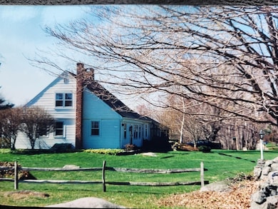
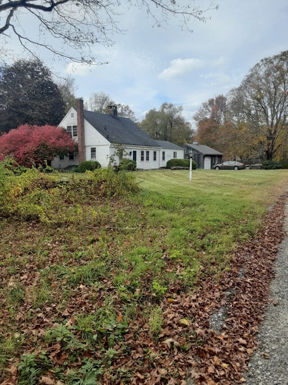
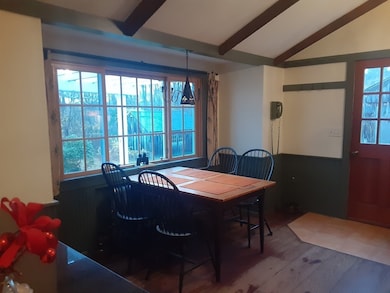
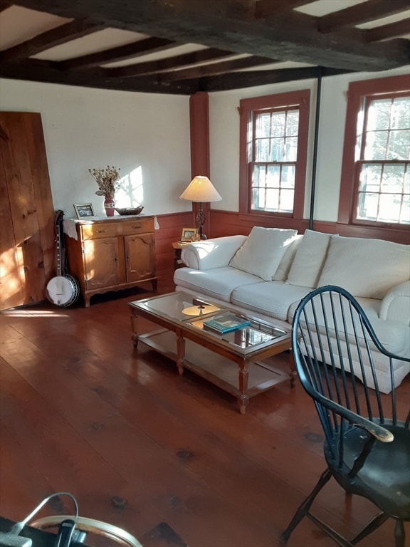
Enjoy the splendor of exceptional tranquility on your own 12 acre mini estate; circa 1760 pre-American Revolutionary War cape has 2 bedrooms 1.5 baths, wide board floors throughout, original exposed chestnut beams, 3 fireplaces that all work, kitchen granite counters, glass/screen sunporch, 20' x 30' garage that includes a heated/air-conditioned home office, an oak post & beam carriage shed out back, a small stream, ideal for a mini farm, hunting, etc. 462' of road frontage means potentially subdividable for another house lot w/in-law apartment as the zoning allows. If considering adding an in-law to the existing house, the septic system the owner installed is for 4 bedrooms. While the driveway is 50' from paved Leonard Rd, if you have a few horses or like to walk your dogs, this home is one of only 4 houses on 4,000' long Blodgett Rd which is a designated scenic town-maintained gravel road, meaning paving would require a vote of over half the property owners.
Home Details
Home Type
- Single Family
Est. Annual Taxes
- $6,121
Year Built
- Built in 1760
Lot Details
- 12 Acre Lot
- Gentle Sloping Lot
- Property is zoned AAA
Parking
- 1 Car Detached Garage
- Off-Street Parking
Home Design
- Cape Cod Architecture
- Antique Architecture
- Stone Foundation
- Frame Construction
- Shingle Roof
Interior Spaces
- 1,614 Sq Ft Home
- 3 Fireplaces
- Basement Fills Entire Space Under The House
Bedrooms and Bathrooms
- 2 Bedrooms
Outdoor Features
- Enclosed Patio or Porch
Utilities
- Window Unit Cooling System
- Heating System Uses Oil
- Heating System Uses Steam
- Private Water Source
- Water Heater
- Private Sewer
Community Details
Overview
- No Home Owners Association
- Near Conservation Area
Amenities
- Medical Services
Recreation
- Tennis Courts
- Park
Map
Home Values in the Area
Average Home Value in this Area
Tax History
| Year | Tax Paid | Tax Assessment Tax Assessment Total Assessment is a certain percentage of the fair market value that is determined by local assessors to be the total taxable value of land and additions on the property. | Land | Improvement |
|---|---|---|---|---|
| 2025 | $8,782 | $158,620 | $58,730 | $99,890 |
| 2024 | $6,121 | $158,620 | $58,730 | $99,890 |
| 2023 | $5,831 | $158,620 | $58,730 | $99,890 |
| 2022 | $5,675 | $158,620 | $58,730 | $99,890 |
| 2021 | $4,978 | $158,620 | $58,730 | $99,890 |
| 2020 | $4,978 | $158,410 | $64,540 | $93,870 |
| 2019 | $4,955 | $158,410 | $64,540 | $93,870 |
| 2018 | $5,427 | $158,410 | $64,540 | $93,870 |
| 2017 | $5,375 | $158,410 | $64,540 | $93,870 |
| 2016 | $4,088 | $158,410 | $64,540 | $93,870 |
| 2015 | $5,134 | $153,860 | $64,540 | $89,320 |
| 2014 | $5,082 | $153,860 | $64,540 | $89,320 |
Property History
| Date | Event | Price | List to Sale | Price per Sq Ft |
|---|---|---|---|---|
| 12/11/2025 12/11/25 | For Sale | $395,000 | -- | $245 / Sq Ft |
Purchase History
| Date | Type | Sale Price | Title Company |
|---|---|---|---|
| Warranty Deed | $180,000 | -- |
Mortgage History
| Date | Status | Loan Amount | Loan Type |
|---|---|---|---|
| Open | $88,800 | No Value Available | |
| Closed | $50,000 | No Value Available | |
| Closed | $171,000 | Unknown |
Source: MLS Property Information Network (MLS PIN)
MLS Number: 73461732
APN: STAF-000006-000007
Disclaimer: Certain information contained herein is derived from information provided by parties other than Homes.com. All information provided is deemed reliable, but is not guaranteed to be accurate and should be independently verified.
![]() The property listing data and information, or the Images, set forth herein were provided to MLS Property Information Network, Inc. from third party sources, including sellers, lessors and public records, and were compiled by MLS Property Information Network, Inc. The property listing data and information, and the Images, are for the personal, non-commercial use of consumers having a good faith interest in purchasing or leasing listed properties of the type displayed to them and may not be used for any purpose other than to identify prospective properties which such consumers may have a good faith interest in purchasing or leasing. MLS Property Information Network, Inc. and its subscribers disclaim any and all representations and warranties as to the accuracy of the property listing data and information, or as to the accuracy of any of the Images, set forth herein.
The property listing data and information, or the Images, set forth herein were provided to MLS Property Information Network, Inc. from third party sources, including sellers, lessors and public records, and were compiled by MLS Property Information Network, Inc. The property listing data and information, and the Images, are for the personal, non-commercial use of consumers having a good faith interest in purchasing or leasing listed properties of the type displayed to them and may not be used for any purpose other than to identify prospective properties which such consumers may have a good faith interest in purchasing or leasing. MLS Property Information Network, Inc. and its subscribers disclaim any and all representations and warranties as to the accuracy of the property listing data and information, or as to the accuracy of any of the Images, set forth herein.
- 283 Leonard Rd
- 150 Stafford Hollow Rd
- 24 Ash St
- 10 Ash St
- 221 Moulton Hill Rd
- 0 Stony Ln
- 192 Leonard Rd
- 96 Stafford Hollow Rd
- 14 Valley View Dr
- 12 Hillcrest Dr
- 89 Crow Hill Rd
- 105 Leonard Rd
- 41 Delphi Rd
- 10 Laurel Ln
- 100 Upper Rd
- 15 Deepwood Dr
- 118 Lake Shore Blvd
- 2 Pinewood Ln
- 4 Pinewood Ln
- 31 Lake Shore Blvd
- 49 Hydeville Rd
- 132 Furnace Ave
- 68 W Main St
- 38-40 Converse St Unit C
- 22 Gold St Unit Gold Street Apartments
- 24 Margaret St Unit 24L
- 200 Brimfield Rd
- 3 Pine Tree Dr
- 8 South Rd Unit 10
- 86 Buff Cap Rd
- 371 Wilbraham St Unit 1
- 31 Randall St Unit 1
- 18 Clifford Ave
- 247 Tolland Turnpike Unit A
- 2009 High St Unit 2013
- 51 Meadow Brook Rd
- 601 Hazard Ave
- 1 Lariviere Ave
- 16 Crescent Beach Dr
- 229 Ramblewood Dr
