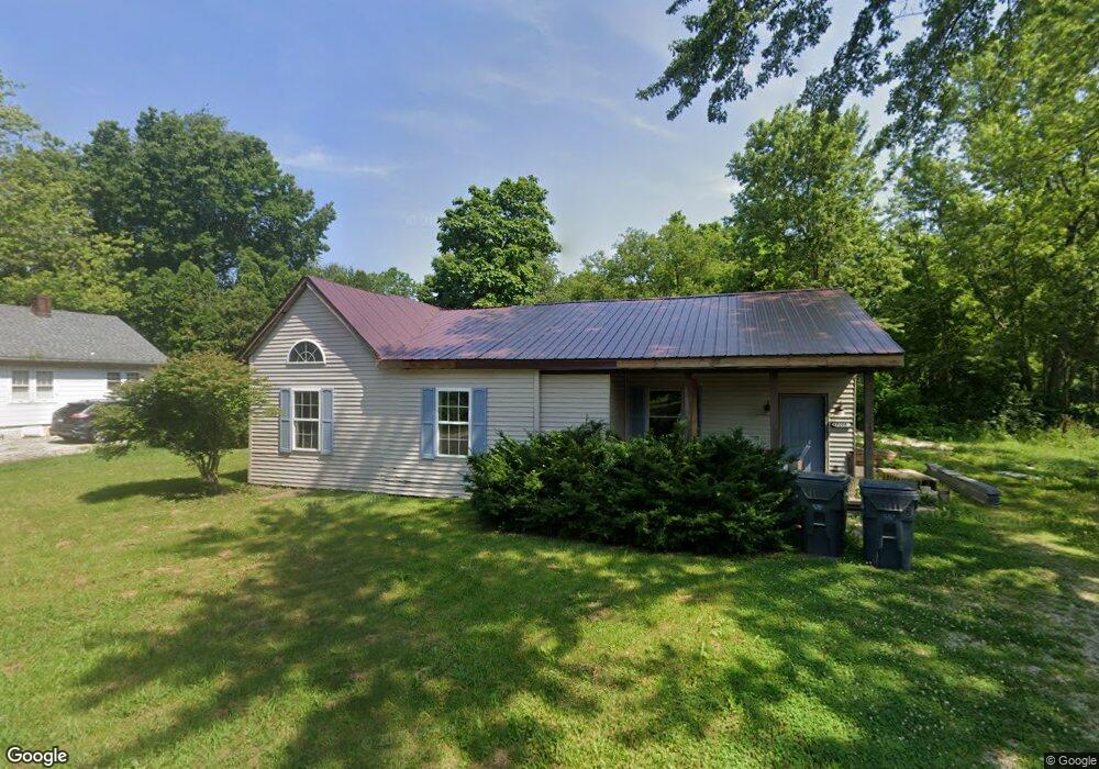
8008 W Cornbread Rd Yorktown, IN 47396
Estimated Value: $158,000 - $187,156
2
Beds
1
Bath
1,760
Sq Ft
$99/Sq Ft
Est. Value
About This Home
This home is located at 8008 W Cornbread Rd, Yorktown, IN 47396 and is currently estimated at $174,289, approximately $99 per square foot. 8008 W Cornbread Rd is a home located in Delaware County with nearby schools including Yorktown Elementary School, Pleasant View Elementary School, and Yorktown Middle School.
Ownership History
Date
Name
Owned For
Owner Type
Purchase Details
Closed on
Jun 20, 2023
Sold by
Kalley Eric R and Kalley Lisa N
Bought by
Spacedream B & K Llc
Current Estimated Value
Purchase Details
Closed on
Jul 31, 2020
Sold by
Kalley Aaron D
Bought by
Kalley Eric R and Kalley Lisa N
Purchase Details
Closed on
Oct 26, 2011
Sold by
Kalley Kent and Kalley Sheila
Bought by
Kalley Kent and Kalley Aaron D
Create a Home Valuation Report for This Property
The Home Valuation Report is an in-depth analysis detailing your home's value as well as a comparison with similar homes in the area
Purchase History
| Date | Buyer | Sale Price | Title Company |
|---|---|---|---|
| Spacedream B & K Llc | -- | None Listed On Document | |
| Kalley Eric R | -- | None Available | |
| Kalley Kent | -- | None Available |
Source: Public Records
Tax History
| Year | Tax Paid | Tax Assessment Tax Assessment Total Assessment is a certain percentage of the fair market value that is determined by local assessors to be the total taxable value of land and additions on the property. | Land | Improvement |
|---|---|---|---|---|
| 2025 | $1,510 | $91,100 | $14,500 | $76,600 |
| 2024 | $1,510 | $73,800 | $14,500 | $59,300 |
| 2023 | $554 | $73,800 | $14,500 | $59,300 |
| 2022 | $526 | $67,700 | $14,500 | $53,200 |
| 2021 | $1,307 | $62,100 | $13,700 | $48,400 |
| 2020 | $373 | $49,000 | $12,500 | $36,500 |
| 2019 | $348 | $46,300 | $11,400 | $34,900 |
| 2018 | $323 | $46,300 | $11,400 | $34,900 |
| 2017 | $719 | $42,900 | $9,800 | $33,100 |
| 2016 | $1,327 | $63,400 | $15,600 | $47,800 |
| 2014 | $1,301 | $62,100 | $15,600 | $46,500 |
| 2013 | -- | $61,600 | $15,600 | $46,000 |
Source: Public Records
Map
Nearby Homes
- 2520 S Andrews Rd
- 2201 S Webster Dr
- 2660 S Benegar Ave
- 7816 W Frankie Ln
- 7909 W Kennedy Pkwy
- 2011 S Haverhill Dr
- 1801 S O'Hare Blvd
- 8808 W Cornbread Rd
- 1600 S O'Hare Blvd
- 3001 S Broadway St
- 9013 W Arch St
- 2421 S Market St
- 9118 W Canal St
- 0 W Cornbread Rd
- 9408 W High St
- 1613 S Italiano Dr
- 422 S Bridgewater Ln
- 413 S Bridgewater Ln
- 514 Greenland Ln
- 6225 W Penrod Rd
- 8012 W Cornbread Rd
- 8001 W Cornbread Rd
- 7925 W Cornbread Rd
- 8016 W Cornbread Rd
- 2490 S Andrews Rd
- 7917 W Cornbread Rd
- 8021 W Cornbread Rd
- 8013 W Cornbread Rd
- 7909 W Cornbread Rd
- 2512 S Andrews Rd
- 2516 S Andrews Rd
- 7901 W Cornbread Rd
- 8101 W Cornbread Rd
- 7913 W South Dr
- 2517 S Andrews Rd
- 8013 W South Dr
- 8013 W South Dr Unit SR
- 8109 W Cornbread Rd
- 7909 W South Dr
- 7905 W South Dr
Your Personal Tour Guide
Ask me questions while you tour the home.