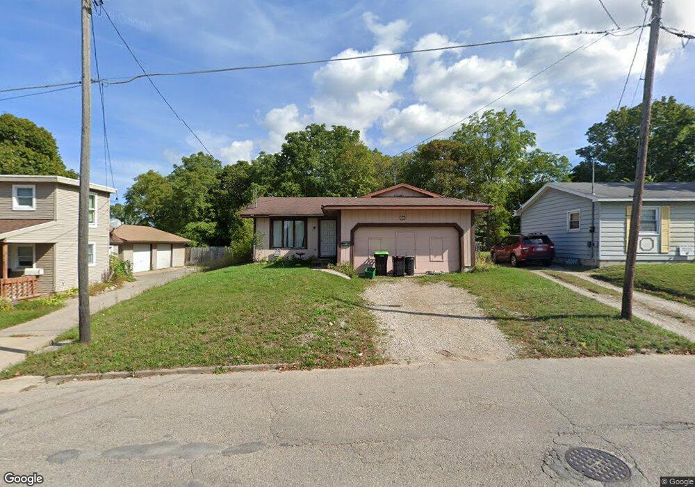
801 Maple St Petoskey, MI 49770
Estimated Value: $281,941 - $404,000
3
Beds
1
Bath
960
Sq Ft
$338/Sq Ft
Est. Value
About This Home
This home is located at 801 Maple St, Petoskey, MI 49770 and is currently estimated at $324,735, approximately $338 per square foot. 801 Maple St is a home located in Emmet County with nearby schools including Petoskey High School, St. Francis Xavier School, and Petoskey Montessori Children's.
Ownership History
Date
Name
Owned For
Owner Type
Purchase Details
Closed on
Apr 29, 2011
Sold by
Page Timothy J and Page Elise D
Bought by
Ewing Christopher M and Ewing Melissa A
Current Estimated Value
Home Financials for this Owner
Home Financials are based on the most recent Mortgage that was taken out on this home.
Original Mortgage
$77,720
Outstanding Balance
$54,012
Interest Rate
4.88%
Estimated Equity
$270,723
Purchase Details
Closed on
Jun 13, 2008
Sold by
Robarge Adam C
Bought by
Page Timothy J and Page Elise D
Home Financials for this Owner
Home Financials are based on the most recent Mortgage that was taken out on this home.
Original Mortgage
$126,022
Interest Rate
6.05%
Purchase Details
Closed on
Apr 20, 2001
Sold by
Robarge Adam C and Robarge Robyn
Bought by
Robarge Adam C
Purchase Details
Closed on
Sep 1, 1997
Bought by
Robarge Pta
Create a Home Valuation Report for This Property
The Home Valuation Report is an in-depth analysis detailing your home's value as well as a comparison with similar homes in the area
Home Values in the Area
Average Home Value in this Area
Purchase History
| Date | Buyer | Sale Price | Title Company |
|---|---|---|---|
| Ewing Christopher M | $75,000 | -- | |
| Page Timothy J | $128,000 | -- | |
| Robarge Adam C | -- | -- | |
| Robarge Pta | $81,500 | -- |
Source: Public Records
Mortgage History
| Date | Status | Borrower | Loan Amount |
|---|---|---|---|
| Open | Ewing Christopher M | $77,720 | |
| Previous Owner | Page Timothy J | $126,022 |
Source: Public Records
Tax History
| Year | Tax Paid | Tax Assessment Tax Assessment Total Assessment is a certain percentage of the fair market value that is determined by local assessors to be the total taxable value of land and additions on the property. | Land | Improvement |
|---|---|---|---|---|
| 2025 | $1,693 | $142,900 | $142,900 | $0 |
| 2024 | $16 | $121,000 | $121,000 | $0 |
| 2023 | $1,552 | $90,100 | $90,100 | $0 |
| 2022 | $1,552 | $84,300 | $84,300 | $0 |
| 2021 | $1,511 | $80,300 | $80,300 | $0 |
| 2020 | $1,528 | $67,600 | $67,600 | $0 |
| 2019 | -- | $66,400 | $66,400 | $0 |
| 2018 | -- | $60,100 | $60,100 | $0 |
| 2017 | -- | $50,300 | $50,300 | $0 |
| 2016 | -- | $48,000 | $48,000 | $0 |
| 2015 | -- | $44,600 | $0 | $0 |
| 2014 | -- | $38,800 | $0 | $0 |
Source: Public Records
Map
Nearby Homes
- 46 Bridge St
- 431 Madison St
- 316 Monroe St
- 513 Liberty St
- 415 Liberty St
- 319 W Mitchell St
- 420 Wachtel Ave
- 1023 Emmet St
- 1035 Emmet St
- 138 E Sheridan St
- 308 Fulton St
- 120 E Lake St
- 1223 Petoskey St
- 1750 Spring St
- 1012 Jefferson Ave
- 204 Winfield Ave
- 1200 Charlevoix Ave Unit 3
- 410 E Mitchell St Unit 2F
- 410 E Mitchell St Unit C
- 431 Carleton St
Your Personal Tour Guide
Ask me questions while you tour the home.