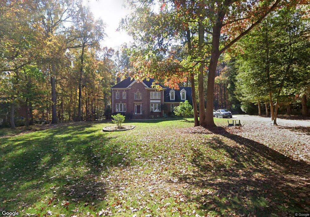
805 Nolstead Ct Raleigh, NC 27614
Falls Lake NeighborhoodEstimated Value: $751,374 - $877,000
4
Beds
3
Baths
3,326
Sq Ft
$250/Sq Ft
Est. Value
About This Home
This home is located at 805 Nolstead Ct, Raleigh, NC 27614 and is currently estimated at $830,094, approximately $249 per square foot. 805 Nolstead Ct is a home located in Wake County with nearby schools including Pleasant Union Elementary School, West Millbrook Middle School, and Millbrook High School.
Ownership History
Date
Name
Owned For
Owner Type
Purchase Details
Closed on
Jul 20, 2006
Sold by
Abraham Carol D and Abraham Philip D
Bought by
Harb George A and Harb Denise S
Current Estimated Value
Home Financials for this Owner
Home Financials are based on the most recent Mortgage that was taken out on this home.
Original Mortgage
$332,000
Outstanding Balance
$195,901
Interest Rate
6.54%
Mortgage Type
Purchase Money Mortgage
Estimated Equity
$634,193
Purchase Details
Closed on
Dec 9, 2005
Sold by
Rock Ronald C
Bought by
Abraham Carol D
Create a Home Valuation Report for This Property
The Home Valuation Report is an in-depth analysis detailing your home's value as well as a comparison with similar homes in the area
Home Values in the Area
Average Home Value in this Area
Purchase History
| Date | Buyer | Sale Price | Title Company |
|---|---|---|---|
| Harb George A | $415,000 | None Available | |
| Abraham Carol D | -- | None Available |
Source: Public Records
Mortgage History
| Date | Status | Borrower | Loan Amount |
|---|---|---|---|
| Open | Harb George A | $332,000 |
Source: Public Records
Tax History
| Year | Tax Paid | Tax Assessment Tax Assessment Total Assessment is a certain percentage of the fair market value that is determined by local assessors to be the total taxable value of land and additions on the property. | Land | Improvement |
|---|---|---|---|---|
| 2025 | $4,442 | $691,299 | $175,000 | $516,299 |
| 2024 | $4,313 | $691,299 | $175,000 | $516,299 |
Source: Public Records
Map
Nearby Homes
- 1220 Hillingdon Way
- 10848 Leslie Dr
- 5768 Cavanaugh Dr
- 812 Stradella Rd
- 2424 Heartley Dr
- 2616 Countrywood Rd
- 5808 Norwood Ridge Dr
- 14124 Norwood Rd
- 600 Hawick Rd
- 5420 Winding View Ln
- 5428 Winding View Ln
- 1112 Stone Kirk Dr
- 5112 Bella Ridge Dr
- 6736 Brixley Crest Ct
- 5204 Barton View Ct
- 400 Dunwoody Dr
- 10120 Lobley Hill Ln
- 1005 Berwyn Way
- 401 Martindale Dr
- 6804 Brixley Cir
- 809 Nolstead Ct
- 801 Nolstead Ct
- 800 Nolstead Ct
- 808 Nolstead Ct
- 817 Nolstead Ct
- 10509 Simtree Ct
- 10508 Simtree Ct
- 820 Nolstead Ct
- 816 Nolstead Ct
- 821 Nolstead Ct
- 10608 Tredwood Dr
- 10600 Tredwood Dr
- 10517 Tredwood Dr
- 10621 Tredwood Dr
- 10505 Simtree Ct
- 10625 Tredwood Dr
- 10625 Tredwood Dr Unit 8
- 10624 Tredwood Dr
- 901 Kinsdale Dr
- 10500 Simtree Ct
Your Personal Tour Guide
Ask me questions while you tour the home.