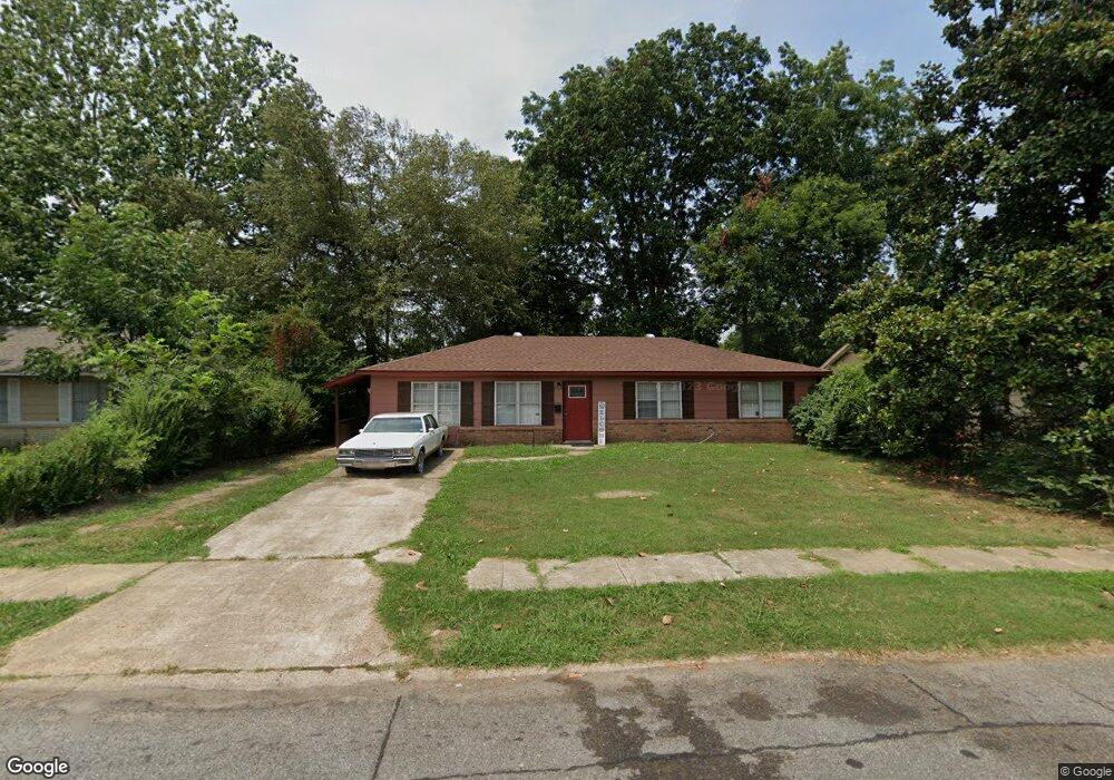
805 Pecan Dr West Memphis, AR 72301
Estimated Value: $64,000 - $152,000
3
Beds
2
Baths
1,300
Sq Ft
$90/Sq Ft
Est. Value
About This Home
This home is located at 805 Pecan Dr, West Memphis, AR 72301 and is currently estimated at $117,063, approximately $90 per square foot. 805 Pecan Dr is a home located in Crittenden County with nearby schools including Faulk Elementary School, Wonder Junior High School, and The Academies of West Memphis Charter School.
Ownership History
Date
Name
Owned For
Owner Type
Purchase Details
Closed on
Aug 30, 2021
Sold by
Perrys Projects & Repair Llc
Bought by
Perry Meredith
Current Estimated Value
Purchase Details
Closed on
Nov 8, 2018
Sold by
Va
Bought by
Perry Lee
Purchase Details
Closed on
Oct 16, 2018
Sold by
State Lands Commissioner
Bought by
Va
Purchase Details
Closed on
Aug 24, 2018
Sold by
Midfirst Bank
Bought by
Va
Purchase Details
Closed on
Aug 14, 2018
Sold by
Crittenden County Sheriff
Bought by
Mcconnell Randall and Mcconnell Tina Renee
Purchase Details
Closed on
Nov 1, 1989
Bought by
Hill John Lee and Hill Willie B
Purchase Details
Closed on
Jan 1, 1986
Bought by
To
Create a Home Valuation Report for This Property
The Home Valuation Report is an in-depth analysis detailing your home's value as well as a comparison with similar homes in the area
Home Values in the Area
Average Home Value in this Area
Purchase History
| Date | Buyer | Sale Price | Title Company |
|---|---|---|---|
| Perry Meredith | -- | Stewart Title | |
| Perry Lee | -- | None Available | |
| Va | -- | None Available | |
| Va | -- | None Available | |
| Mcconnell Randall | -- | None Available | |
| Hill John Lee | $45,000 | -- | |
| To | $40,000 | -- |
Source: Public Records
Tax History Compared to Growth
Tax History
| Year | Tax Paid | Tax Assessment Tax Assessment Total Assessment is a certain percentage of the fair market value that is determined by local assessors to be the total taxable value of land and additions on the property. | Land | Improvement |
|---|---|---|---|---|
| 2024 | $634 | $13,100 | $3,200 | $9,900 |
| 2023 | $634 | $13,100 | $3,200 | $9,900 |
| 2022 | $634 | $13,100 | $3,200 | $9,900 |
| 2021 | $634 | $13,100 | $3,200 | $9,900 |
| 2020 | $593 | $13,100 | $3,200 | $9,900 |
| 2019 | $508 | $13,430 | $3,200 | $10,230 |
| 2018 | $62 | $13,430 | $3,200 | $10,230 |
| 2017 | $62 | $13,430 | $3,200 | $10,230 |
| 2016 | $62 | $13,430 | $3,200 | $10,230 |
| 2015 | $66 | $13,430 | $3,200 | $10,230 |
| 2014 | $66 | $10,020 | $3,200 | $6,820 |
Source: Public Records
Map
Nearby Homes
- 819 Walnut Dr
- 912 Mimosa Dr
- 811 Maple Dr
- 920 Mimosa Dr
- 1003 Mimosa Dr
- 806 W Walnut Dr
- 905 Foxwood Cir
- 715 Foxwood St
- 237 W Jefferson Ave
- 503 Tulane Dr
- 501 Oxford St
- 908 Winchell St
- 402 Oxford St
- 1200 Winchell St
- 000 Garrison Ave
- 522 Lois Marie Cove
- 765 Dogwood Cove
- 186 Anna Ln
- 152 Anna Ln
- 503 W Oliver Ave