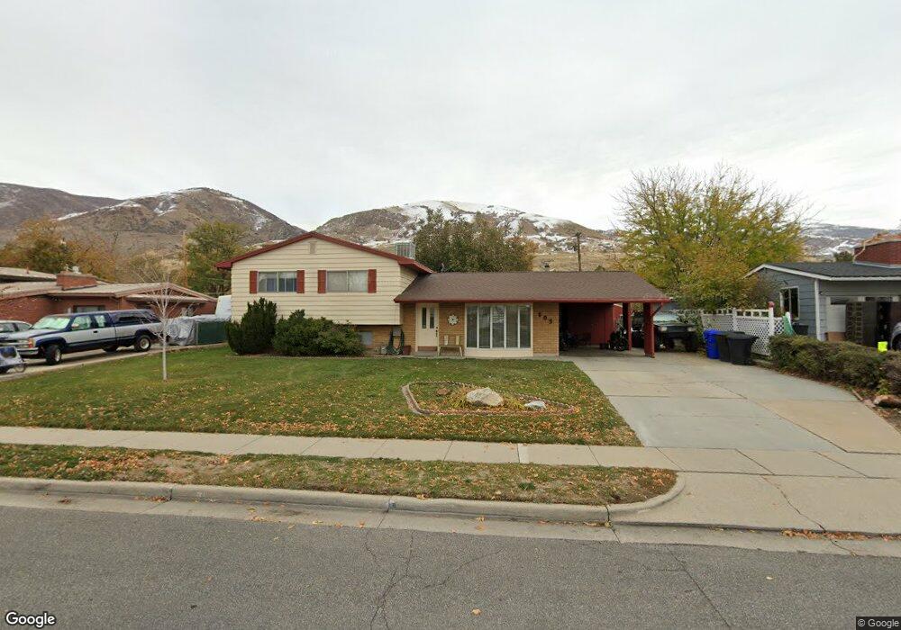
805 S 300 E Centerville, UT 84014
Estimated Value: $525,000 - $628,000
4
Beds
3
Baths
1,913
Sq Ft
$303/Sq Ft
Est. Value
About This Home
This home is located at 805 S 300 E, Centerville, UT 84014 and is currently estimated at $580,539, approximately $303 per square foot. 805 S 300 E is a home located in Davis County with nearby schools including J A Taylor Elementary School, Centerville Jr High, and Viewmont High School.
Ownership History
Date
Name
Owned For
Owner Type
Purchase Details
Closed on
Nov 23, 2009
Sold by
Knuth Karrin R and Powell Karrin R
Bought by
Knuth Karrin R and Knuth Perry D
Current Estimated Value
Home Financials for this Owner
Home Financials are based on the most recent Mortgage that was taken out on this home.
Original Mortgage
$112,000
Outstanding Balance
$72,682
Interest Rate
4.88%
Mortgage Type
New Conventional
Estimated Equity
$507,857
Purchase Details
Closed on
Aug 4, 2003
Sold by
Powell Chris A
Bought by
Powell Karrin R
Purchase Details
Closed on
Jun 4, 1998
Sold by
Brough David L and Brough Gayle C
Bought by
Powell Chris A and Powell Karrin R
Home Financials for this Owner
Home Financials are based on the most recent Mortgage that was taken out on this home.
Original Mortgage
$125,000
Interest Rate
7.1%
Create a Home Valuation Report for This Property
The Home Valuation Report is an in-depth analysis detailing your home's value as well as a comparison with similar homes in the area
Purchase History
| Date | Buyer | Sale Price | Title Company |
|---|---|---|---|
| Knuth Karrin R | -- | Bonneville Superior Title Co | |
| Powell Karrin R | -- | -- | |
| Powell Chris A | -- | Bonneville Title Company |
Source: Public Records
Mortgage History
| Date | Status | Borrower | Loan Amount |
|---|---|---|---|
| Open | Knuth Karrin R | $112,000 | |
| Closed | Powell Chris A | $125,000 |
Source: Public Records
Tax History
| Year | Tax Paid | Tax Assessment Tax Assessment Total Assessment is a certain percentage of the fair market value that is determined by local assessors to be the total taxable value of land and additions on the property. | Land | Improvement |
|---|---|---|---|---|
| 2025 | $3,030 | $289,850 | $183,682 | $106,168 |
| 2024 | $2,923 | $284,350 | $170,316 | $114,034 |
| 2023 | $2,799 | $492,000 | $272,504 | $219,496 |
| 2022 | $2,943 | $284,900 | $138,989 | $145,911 |
| 2021 | $2,739 | $413,000 | $220,034 | $192,966 |
| 2020 | $2,215 | $334,000 | $210,900 | $123,100 |
| 2019 | $2,241 | $330,000 | $198,414 | $131,586 |
| 2018 | $2,090 | $304,000 | $183,419 | $120,581 |
| 2016 | $1,744 | $140,965 | $69,072 | $71,893 |
| 2015 | $1,693 | $129,140 | $69,072 | $60,068 |
| 2014 | $1,447 | $112,881 | $69,072 | $43,809 |
| 2013 | -- | $116,102 | $47,961 | $68,141 |
Source: Public Records
Map
Nearby Homes
- 345 E 600 S
- 967 S Courtyard Ln
- 495 E 475 S
- 610 E Pages Ln
- 16 W 780 S
- 96 Village Square Rd
- 610 S 800 E
- 951 Centerville Commons Way
- 1420 N Main St
- 328 E 1100 S
- 360 E Center St
- 88 W 50 S Unit C-3
- 88 W 50 S Unit B5
- 204 Lyman Ln
- 662 E 1200 N
- 330 W Paradiso Ln
- 1260 N 200 W
- 252 N 400 E
- 328 W Pages Ln
- 235 W 1400 N
Your Personal Tour Guide
Ask me questions while you tour the home.