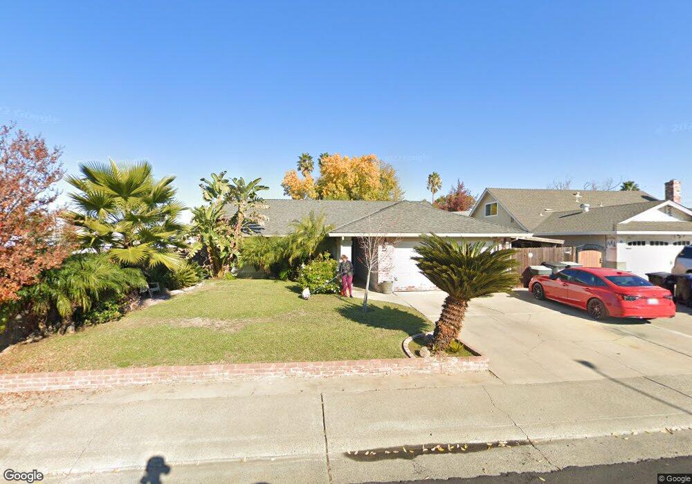
8052 Renton Way Sacramento, CA 95828
Estimated Value: $296,000 - $457,000
4
Beds
2
Baths
1,501
Sq Ft
$274/Sq Ft
Est. Value
About This Home
This home is located at 8052 Renton Way, Sacramento, CA 95828 and is currently estimated at $410,996, approximately $273 per square foot. 8052 Renton Way is a home located in Sacramento County with nearby schools including David Reese Elementary School, James Rutter Middle School, and Florin High School.
Ownership History
Date
Name
Owned For
Owner Type
Purchase Details
Closed on
Dec 30, 1993
Sold by
Carter David Wayne and Carter Cherie Lorraine
Bought by
Robles Ramon E and Robles Enriqueta
Current Estimated Value
Home Financials for this Owner
Home Financials are based on the most recent Mortgage that was taken out on this home.
Original Mortgage
$108,861
Interest Rate
7.09%
Mortgage Type
FHA
Create a Home Valuation Report for This Property
The Home Valuation Report is an in-depth analysis detailing your home's value as well as a comparison with similar homes in the area
Home Values in the Area
Average Home Value in this Area
Purchase History
| Date | Buyer | Sale Price | Title Company |
|---|---|---|---|
| Robles Ramon E | $109,000 | Chicago Title Company |
Source: Public Records
Mortgage History
| Date | Status | Borrower | Loan Amount |
|---|---|---|---|
| Closed | Robles Ramon E | $108,861 |
Source: Public Records
Tax History Compared to Growth
Tax History
| Year | Tax Paid | Tax Assessment Tax Assessment Total Assessment is a certain percentage of the fair market value that is determined by local assessors to be the total taxable value of land and additions on the property. | Land | Improvement |
|---|---|---|---|---|
| 2025 | $1,938 | $185,240 | $37,378 | $147,862 |
| 2024 | $1,938 | $181,609 | $36,646 | $144,963 |
| 2023 | $1,888 | $178,049 | $35,928 | $142,121 |
| 2022 | $1,855 | $174,559 | $35,224 | $139,335 |
| 2021 | $2,128 | $171,137 | $34,534 | $136,603 |
| 2020 | $2,109 | $169,383 | $34,180 | $135,203 |
| 2019 | $2,201 | $166,062 | $33,510 | $132,552 |
| 2018 | $1,725 | $162,806 | $32,853 | $129,953 |
| 2017 | $1,694 | $159,614 | $32,209 | $127,405 |
| 2016 | $1,607 | $156,485 | $31,578 | $124,907 |
| 2015 | $1,575 | $154,135 | $31,104 | $123,031 |
| 2014 | $1,548 | $151,116 | $30,495 | $120,621 |
Source: Public Records
Map
Nearby Homes
- 7467 Power Inn Rd
- 7633 Clement Cir
- 8200 Cottonfield Way
- 7600 Clement Cir
- 7605 Mctavish Cir
- 7625 Par Pkwy
- 8013 Skywoods Way
- 7551 Red Bud Ln
- 7407 Sunborough Ln
- 7716 La Reina Way
- 7548 Huckleberry Ln
- 7451 Albezzia Ln
- 8214 Moorhaven Way
- 7313 Sunsilver Ln
- 7724 La Bandera Way
- 7309 Sunleaf Ln
- 7313 Sunshire Ln
- 7413 Skander Way
- 8207 Wildfire Ln
- 7206 Willowwest Ct
- 8048 Renton Way
- 8024 Renton Way
- 8044 Renton Way
- 8020 Renton Way
- 8053 Renton Way
- 8049 Renton Way
- 7901 Gerber Rd
- 8040 Renton Way
- 8045 Renton Way
- 8028 Renton Way
- 7569 Cottontree Way
- 8041 Renton Way
- 7572 Cottontree Way
- 8016 Renton Way
- 8012 Renton Way
- 8037 Renton Way
- 7565 Cottontree Way
- 7568 Cottontree Way
- 8008 Renton Way
- 7593 MacFinley Way