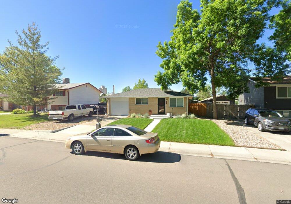
807 E 4th Ave Longmont, CO 80504
Kensington NeighborhoodEstimated Value: $432,000 - $466,000
4
Beds
2
Baths
1,032
Sq Ft
$434/Sq Ft
Est. Value
About This Home
This home is located at 807 E 4th Ave, Longmont, CO 80504 and is currently estimated at $447,772, approximately $433 per square foot. 807 E 4th Ave is a home located in Boulder County with nearby schools including Rocky Mountain Elementary School, Trail Ridge Middle School, and Skyline High School.
Ownership History
Date
Name
Owned For
Owner Type
Purchase Details
Closed on
Jan 21, 2022
Sold by
Jane Leslie Rita
Bought by
Leslie Rita Jane and Leslie Timothy C
Current Estimated Value
Purchase Details
Closed on
Mar 24, 1999
Sold by
Davey Michael F
Bought by
Ibbotson Dale A
Home Financials for this Owner
Home Financials are based on the most recent Mortgage that was taken out on this home.
Original Mortgage
$124,169
Interest Rate
6.69%
Mortgage Type
FHA
Purchase Details
Closed on
May 13, 1996
Sold by
Davey Beverly J and Davey Davey
Bought by
Davey Michael F
Home Financials for this Owner
Home Financials are based on the most recent Mortgage that was taken out on this home.
Original Mortgage
$58,500
Interest Rate
8.06%
Purchase Details
Closed on
Aug 14, 1991
Bought by
Ibbotson Rita J
Purchase Details
Closed on
Aug 21, 1986
Bought by
Ibbotson Rita J
Create a Home Valuation Report for This Property
The Home Valuation Report is an in-depth analysis detailing your home's value as well as a comparison with similar homes in the area
Home Values in the Area
Average Home Value in this Area
Purchase History
| Date | Buyer | Sale Price | Title Company |
|---|---|---|---|
| Leslie Rita Jane | -- | Rosenberg Lpa Llc | |
| Ibbotson Dale A | $125,000 | First American Heritage Titl | |
| Davey Michael F | -- | -- | |
| Ibbotson Rita J | -- | -- | |
| Ibbotson Rita J | -- | -- |
Source: Public Records
Mortgage History
| Date | Status | Borrower | Loan Amount |
|---|---|---|---|
| Previous Owner | Ibbotson Dale A | $124,169 | |
| Previous Owner | Davey Michael F | $58,500 |
Source: Public Records
Tax History
| Year | Tax Paid | Tax Assessment Tax Assessment Total Assessment is a certain percentage of the fair market value that is determined by local assessors to be the total taxable value of land and additions on the property. | Land | Improvement |
|---|---|---|---|---|
| 2025 | $2,279 | $25,162 | $10,131 | $15,031 |
| 2024 | $2,279 | $25,162 | $10,131 | $15,031 |
| 2023 | $2,248 | $23,825 | $11,196 | $16,315 |
| 2022 | $2,047 | $20,683 | $7,902 | $12,781 |
| 2021 | $2,073 | $21,279 | $8,130 | $13,149 |
| 2020 | $1,708 | $17,582 | $7,007 | $10,575 |
| 2019 | $1,681 | $17,582 | $7,007 | $10,575 |
| 2018 | $1,553 | $16,351 | $5,832 | $10,519 |
| 2017 | $1,532 | $18,078 | $6,448 | $11,630 |
| 2016 | $1,384 | $14,479 | $5,174 | $9,305 |
| 2015 | $1,319 | $11,534 | $3,423 | $8,111 |
| 2014 | $1,077 | $11,534 | $3,423 | $8,111 |
Source: Public Records
Map
Nearby Homes
- 737 Goss Dr
- 524 Rider Ridge Dr
- 613 Rider Ridge Dr
- 631 Rider Ridge Rd
- 262 E 5th Ave
- 240 Wadsworth Cir
- 244 Sorento Place
- 500 Lashley St Unit 48
- 140 E 5th Ave
- 820 Brookside Dr
- 902 Sugar Mill Ave
- 128 E 5th Ave
- 265 High Point Dr Unit F-302
- 265 High Point Dr Unit 201
- 265 High Point Dr Unit 204
- 265 High Point Dr Unit 203
- 265 High Point Dr Unit 207
- 104 Rothrock Place
- 245 High Point Dr Unit 104
- 815 Hilltop St
Your Personal Tour Guide
Ask me questions while you tour the home.