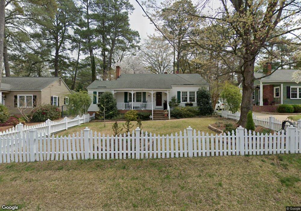
808 Cape Fear Ave Fayetteville, NC 28303
Terry Sanford NeighborhoodEstimated Value: $171,000 - $195,000
3
Beds
2
Baths
1,530
Sq Ft
$122/Sq Ft
Est. Value
About This Home
This home is located at 808 Cape Fear Ave, Fayetteville, NC 28303 and is currently estimated at $185,928, approximately $121 per square foot. 808 Cape Fear Ave is a home located in Cumberland County with nearby schools including Margaret Willis Elementary School, Luther Nick Jeralds Middle School, and Terry Sanford High.
Ownership History
Date
Name
Owned For
Owner Type
Purchase Details
Closed on
Dec 31, 2003
Sold by
Strickland Ervin
Bought by
Barnard Ken
Current Estimated Value
Home Financials for this Owner
Home Financials are based on the most recent Mortgage that was taken out on this home.
Original Mortgage
$61,600
Outstanding Balance
$28,648
Interest Rate
5.82%
Mortgage Type
New Conventional
Estimated Equity
$157,280
Create a Home Valuation Report for This Property
The Home Valuation Report is an in-depth analysis detailing your home's value as well as a comparison with similar homes in the area
Home Values in the Area
Average Home Value in this Area
Purchase History
| Date | Buyer | Sale Price | Title Company |
|---|---|---|---|
| Barnard Ken | $77,000 | -- |
Source: Public Records
Mortgage History
| Date | Status | Borrower | Loan Amount |
|---|---|---|---|
| Open | Barnard Ken | $61,600 |
Source: Public Records
Tax History Compared to Growth
Tax History
| Year | Tax Paid | Tax Assessment Tax Assessment Total Assessment is a certain percentage of the fair market value that is determined by local assessors to be the total taxable value of land and additions on the property. | Land | Improvement |
|---|---|---|---|---|
| 2024 | $1,474 | $81,046 | $20,000 | $61,046 |
| 2023 | $471 | $81,046 | $20,000 | $61,046 |
| 2022 | $1,667 | $81,046 | $20,000 | $61,046 |
| 2021 | $1,250 | $81,046 | $20,000 | $61,046 |
| 2019 | $1,632 | $101,200 | $20,000 | $81,200 |
| 2018 | $1,632 | $101,200 | $20,000 | $81,200 |
| 2017 | $1,529 | $101,200 | $20,000 | $81,200 |
| 2016 | $1,410 | $102,700 | $20,000 | $82,700 |
| 2015 | $1,396 | $102,700 | $20,000 | $82,700 |
| 2014 | $1,389 | $102,700 | $20,000 | $82,700 |
Source: Public Records
Map
Nearby Homes
- 816 Pilot Ave
- 933 Creek Side Run
- 626 Cape Fear Ave
- 725 Greenland Dr
- 1416 Briarcliff Dr Unit 1, 2, 3
- 1412, 1414 Briarcliff Dr
- 831 Anarine Rd
- 1404 Briarcliff Dr Unit 1404, 1406, 1408, 14
- 1400 & 1402 Briarcliff Dr Unit 1400 A/B, 1402
- 915 Anarine Rd
- 714 Westmont Dr
- 717 Glenwood Dr
- 1926 N Pearl St
- 703 Glenwood Dr
- 806 Ethelored St
- 803 Mcpherson Ave
- 810 Cape Fear Ave
- 806 Cape Fear Ave
- 804 Cape Fear Ave
- 807 Cape Fear Ave
- 607 Pearl St
- 809 Cape Fear Ave
- 609 Pearl St
- 805 Cape Fear Ave
- 605 Pearl St
- 1704 Havilah Rd
- 1706 Havilah Rd
- 1708 Havilah Rd
- 1702 Havilah Rd
- 1708 Bragg Blvd
- 1710 Havilah Rd
- 603 Pearl St
- 803 Cape Fear Ave
- 613 Pearl St
- 1704 Bragg Blvd
- 801 Cape Fear Ave