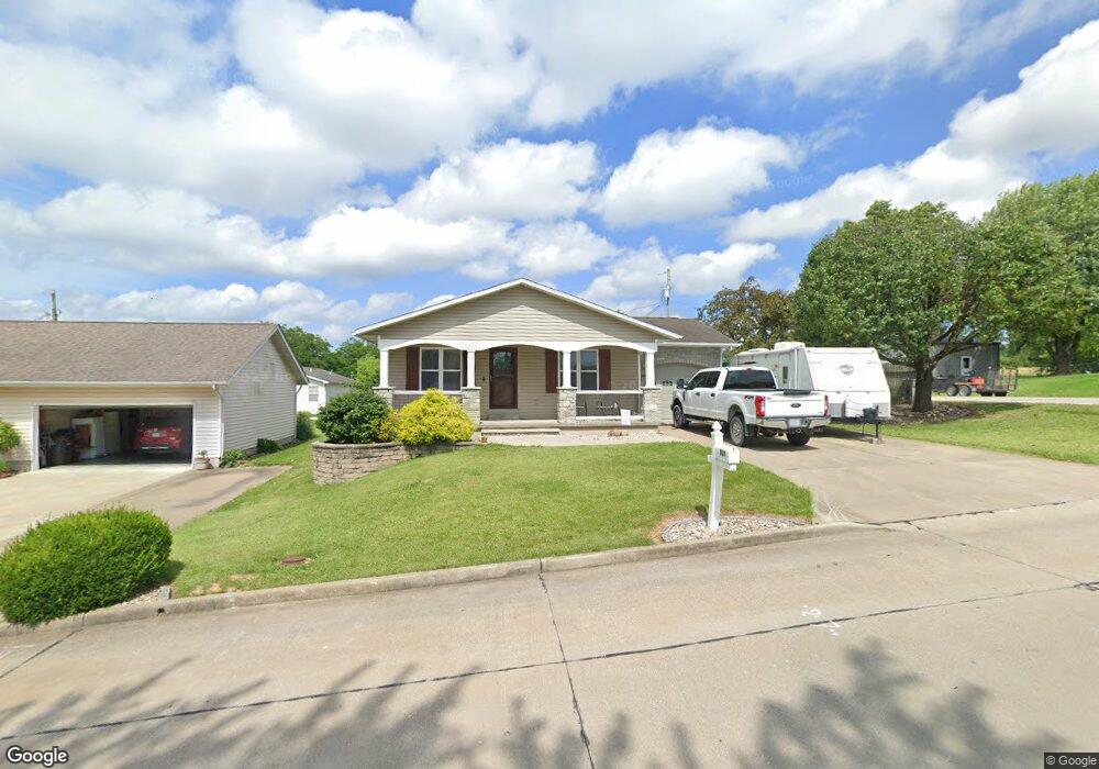
808 Smith St Perryville, MO 63775
Estimated Value: $185,854 - $223,000
3
Beds
3
Baths
1,064
Sq Ft
$186/Sq Ft
Est. Value
About This Home
This home is located at 808 Smith St, Perryville, MO 63775 and is currently estimated at $197,464, approximately $185 per square foot. 808 Smith St is a home located in Perry County with nearby schools including Perryville Primary Center, Perryville Elementary School, and Perry County Middle School.
Ownership History
Date
Name
Owned For
Owner Type
Purchase Details
Closed on
Mar 20, 2017
Sold by
Colin Spousal and Colin Z Q
Bought by
Hotop Derek E
Current Estimated Value
Home Financials for this Owner
Home Financials are based on the most recent Mortgage that was taken out on this home.
Original Mortgage
$129,200
Outstanding Balance
$65,997
Interest Rate
4.19%
Mortgage Type
New Conventional
Estimated Equity
$131,467
Purchase Details
Closed on
Sep 23, 2010
Bought by
Zahner Colin W
Create a Home Valuation Report for This Property
The Home Valuation Report is an in-depth analysis detailing your home's value as well as a comparison with similar homes in the area
Home Values in the Area
Average Home Value in this Area
Purchase History
| Date | Buyer | Sale Price | Title Company |
|---|---|---|---|
| Hotop Derek E | $161,500 | -- | |
| Zahner Colin W | -- | -- |
Source: Public Records
Mortgage History
| Date | Status | Borrower | Loan Amount |
|---|---|---|---|
| Open | Hotop Derek E | $129,200 |
Source: Public Records
Tax History Compared to Growth
Tax History
| Year | Tax Paid | Tax Assessment Tax Assessment Total Assessment is a certain percentage of the fair market value that is determined by local assessors to be the total taxable value of land and additions on the property. | Land | Improvement |
|---|---|---|---|---|
| 2024 | $1,323 | $25,469 | $4,345 | $21,124 |
| 2023 | $1,319 | $25,469 | $4,345 | $21,124 |
| 2022 | $1,283 | $24,745 | $3,621 | $21,124 |
| 2021 | $1,283 | $24,745 | $3,621 | $21,124 |
| 2020 | $1,189 | $22,724 | $3,342 | $19,382 |
| 2019 | $1,186 | $22,724 | $3,342 | $19,382 |
| 2018 | $1,035 | $21,307 | $3,342 | $17,965 |
| 2017 | $1,035 | $21,307 | $3,342 | $17,965 |
| 2016 | $1,035 | $20,416 | $3,420 | $16,996 |
| 2015 | -- | $19,605 | $3,420 | $16,185 |
| 2014 | -- | $19,605 | $3,420 | $16,185 |
Source: Public Records
Map
Nearby Homes
- 424 N Spring St
- 704 S Kingshighway St
- 7c Deerpath Dr
- 23/25/27 W Saint Joseph St
- 221 W Saint Joseph St
- 310 S Walnut St
- 1001 Harry Ave
- 120 S West St
- 1841 N Main St
- 333 Lynnie St
- 306 Cleo St
- 101 Ganahl St
- 1066 Hume St
- 1204 N Moulton St
- 929 Grand Ave
- 601 S Shelby St
- 0 N Highway 51
- 1038 W Saint Joseph St
- 1512 Old Saint Marys Rd
- 1225 Drury Ln