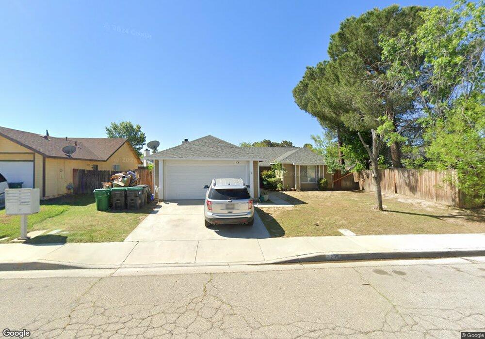
808 Trixis Ave Lancaster, CA 93534
Central Lancaster NeighborhoodEstimated Value: $415,487 - $442,000
4
Beds
2
Baths
1,389
Sq Ft
$306/Sq Ft
Est. Value
About This Home
This home is located at 808 Trixis Ave, Lancaster, CA 93534 and is currently estimated at $425,122, approximately $306 per square foot. 808 Trixis Ave is a home located in Los Angeles County with nearby schools including Mariposa Elementary School, Piute Middle School, and Antelope Valley High School.
Ownership History
Date
Name
Owned For
Owner Type
Purchase Details
Closed on
Sep 9, 2002
Sold by
Toor Arvinder Singh and Toor Susan Renea
Bought by
Alemoh Babatunde
Current Estimated Value
Home Financials for this Owner
Home Financials are based on the most recent Mortgage that was taken out on this home.
Original Mortgage
$127,991
Outstanding Balance
$53,154
Interest Rate
6.16%
Mortgage Type
FHA
Estimated Equity
$371,968
Purchase Details
Closed on
May 6, 1998
Sold by
Singh Arvinder
Bought by
Toor Arvinder Singh and Toor Susan Renee
Create a Home Valuation Report for This Property
The Home Valuation Report is an in-depth analysis detailing your home's value as well as a comparison with similar homes in the area
Home Values in the Area
Average Home Value in this Area
Purchase History
| Date | Buyer | Sale Price | Title Company |
|---|---|---|---|
| Alemoh Babatunde | $130,000 | Fidelity National Title Co | |
| Toor Arvinder Singh | -- | -- |
Source: Public Records
Mortgage History
| Date | Status | Borrower | Loan Amount |
|---|---|---|---|
| Open | Alemoh Babatunde | $127,991 |
Source: Public Records
Tax History
| Year | Tax Paid | Tax Assessment Tax Assessment Total Assessment is a certain percentage of the fair market value that is determined by local assessors to be the total taxable value of land and additions on the property. | Land | Improvement |
|---|---|---|---|---|
| 2025 | $3,728 | $188,257 | $37,643 | $150,614 |
| 2024 | $3,728 | $184,566 | $36,905 | $147,661 |
| 2023 | $3,654 | $180,948 | $36,182 | $144,766 |
| 2022 | $3,460 | $177,401 | $35,473 | $141,928 |
| 2021 | $3,073 | $173,924 | $34,778 | $139,146 |
| 2019 | $2,992 | $168,768 | $33,748 | $135,020 |
| 2018 | $2,942 | $165,460 | $33,087 | $132,373 |
| 2016 | $2,798 | $159,037 | $31,803 | $127,234 |
| 2015 | $2,699 | $151,000 | $30,200 | $120,800 |
| 2014 | $2,572 | $138,000 | $27,600 | $110,400 |
Source: Public Records
Map
Nearby Homes
- 719 W Avenue h2
- 734 W Avenue h2
- 45826 Desert Springs Dr
- 0 Avenue H Unit SR25253450
- 0 Avenue H Unit DW25078169
- 0 Avenue H Unit OC26036714
- 0 Avenue H Unit SR25143025
- 0 Avenue H Unit 24-469937
- 0 Avenue H Unit 25008146
- 1041 W Avenue h2
- 0 Sierra Hwy Unit 22004238
- 828 W Avenue h6
- 737 W Avenue h7
- 1046 W Avenue H-6
- 45650 Fig Ave
- 755 W Holguin St
- 0 Vac Vic Avenue G6 65th W Unit SR21034311
- 45839 York Place
- 1029 W Avenue h8
- 1132 W Holguin St
- 802 Trixis Ave
- 45934 Foxtail St
- 45928 Foxtail St
- 757 Twinberry Ln
- 762 Trixis Ave
- 45922 Foxtail St
- 807 Trixis Ave
- 815 Trixis Ave
- 753 Twinberry Ln
- 761 Twinberry Ln
- 801 Trixis Ave
- 756 Trixis Ave
- 821 Trixis Ave
- 45916 Foxtail St
- 747 Twinberry Ln
- 757 Trixis Ave
- 750 Trixis Ave
- 45910 Foxtail St
- 45935 Foxtail St
- 45929 Foxtail St
Your Personal Tour Guide
Ask me questions while you tour the home.