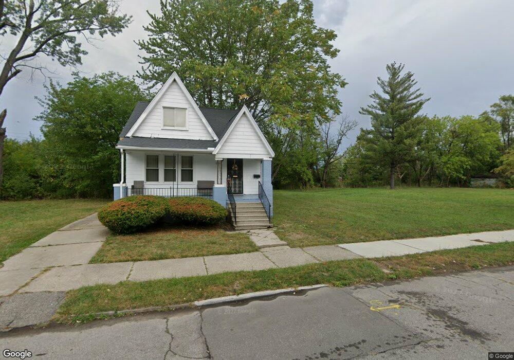
8091 Quinn St Detroit, MI 48234
Mount Olivet NeighborhoodEstimated Value: $83,000 - $114,000
3
Beds
2
Baths
1,452
Sq Ft
$68/Sq Ft
Est. Value
About This Home
This home is located at 8091 Quinn St, Detroit, MI 48234 and is currently estimated at $98,500, approximately $67 per square foot. 8091 Quinn St is a home located in Wayne County with nearby schools including Marion Law Academy, Edward 'Duke' Ellington Conservatory of Music and Art, and Charles L. Spain Elementary-Middle School.
Ownership History
Date
Name
Owned For
Owner Type
Purchase Details
Closed on
Feb 7, 2013
Sold by
Wayne County Treasurer
Bought by
Planning & Development Dept City Of Detr
Current Estimated Value
Purchase Details
Closed on
Jan 29, 2009
Sold by
Deutsche Bank National Trust Company
Bought by
Paramount Land Holdings Llc
Purchase Details
Closed on
May 10, 2006
Sold by
Griffin Katrina and Griffin Kevin
Bought by
Deutsche Bank National Trust Co
Purchase Details
Closed on
Apr 19, 2003
Sold by
Michigan State Housing Development Autho
Bought by
Griffin Katrina
Create a Home Valuation Report for This Property
The Home Valuation Report is an in-depth analysis detailing your home's value as well as a comparison with similar homes in the area
Home Values in the Area
Average Home Value in this Area
Purchase History
| Date | Buyer | Sale Price | Title Company |
|---|---|---|---|
| Planning & Development Dept City Of Detr | -- | None Available | |
| Paramount Land Holdings Llc | -- | None Available | |
| Deutsche Bank National Trust Co | $54,000 | None Available | |
| Griffin Katrina | -- | -- |
Source: Public Records
Tax History Compared to Growth
Tax History
| Year | Tax Paid | Tax Assessment Tax Assessment Total Assessment is a certain percentage of the fair market value that is determined by local assessors to be the total taxable value of land and additions on the property. | Land | Improvement |
|---|---|---|---|---|
| 2025 | -- | $0 | $0 | $0 |
| 2024 | -- | $0 | $0 | $0 |
| 2023 | $0 | $0 | $0 | $0 |
| 2022 | -- | $0 | $0 | $0 |
| 2021 | $0 | $0 | $0 | $0 |
| 2020 | $1,226 | $0 | $0 | $0 |
| 2019 | $1,226 | $0 | $0 | $0 |
| 2018 | $0 | $0 | $0 | $0 |
| 2017 | -- | $0 | $0 | $0 |
| 2016 | $340 | $0 | $0 | $0 |
| 2015 | $1,199 | $0 | $0 | $0 |
| 2013 | $1,199 | $22,901 | $0 | $0 |
| 2010 | -- | $33,575 | $663 | $32,912 |
Source: Public Records
Map
Nearby Homes
- 8119 E Hildale St
- 8100 Stockton St
- 8062 Stockton St
- 8095 Orion St
- 8291 E Brentwood St
- 19126 Stotter St
- 7483 E Brentwood St
- 18666 Carrie St
- 5727 E Outer Dr
- 18824 Helen St
- 19190 Rogge St
- 19161 Rogge St
- 19202 Rogge St
- 7401 Buhr St
- 8022 Yolanda St
- 7434 Buhr St
- 19357 Packard St
- 19363 Packard St
- 8063 Yolanda St
- 18035 Helen St
- 8083 Quinn St
- 8105 Quinn St
- 8077 Quinn St
- 8111 Quinn St
- 8069 Quinn St
- 8092 E Robinwood St
- 8084 E Robinwood St
- 8098 E Robinwood St
- 8119 Quinn St
- 8078 E Robinwood St
- 8090 Quinn St
- 8082 Quinn St
- 8096 Quinn St
- 8076 Quinn St
- 8104 Quinn St
- 8125 Quinn St
- 8070 Quinn St
- 8063 Quinn St
- 8070 E Robinwood St
- 8055 Quinn St