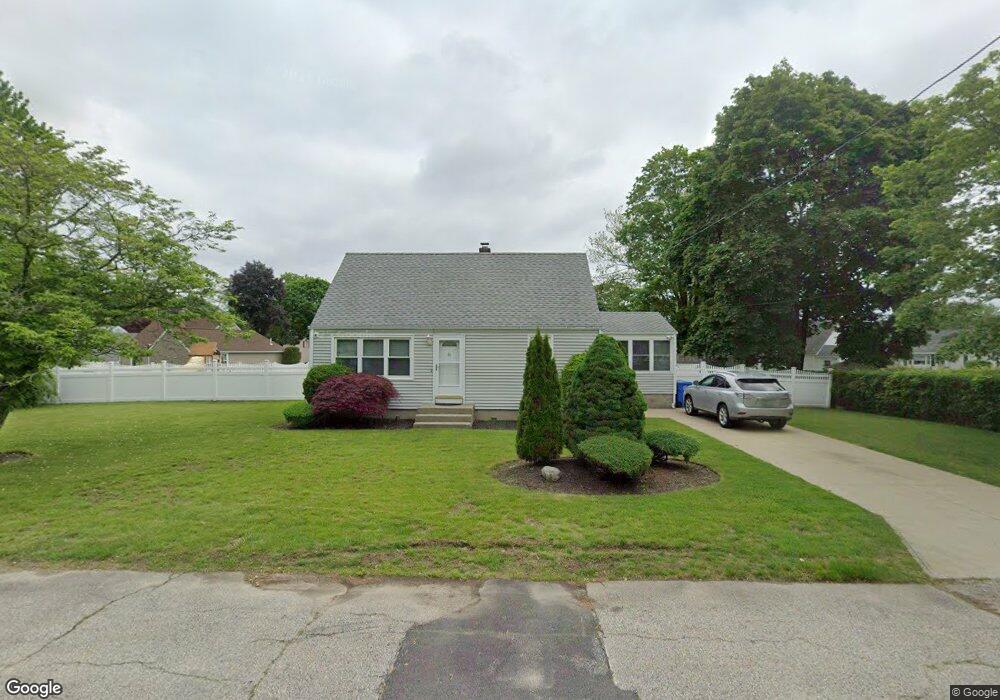
81 Midland Dr Cranston, RI 02920
Comstock Gardens NeighborhoodEstimated Value: $402,000 - $421,943
3
Beds
1
Bath
1,152
Sq Ft
$358/Sq Ft
Est. Value
About This Home
This home is located at 81 Midland Dr, Cranston, RI 02920 and is currently estimated at $412,986, approximately $358 per square foot. 81 Midland Dr is a home located in Providence County with nearby schools including George J. Peters School, Western Hills Middle School, and Cranston High School West.
Ownership History
Date
Name
Owned For
Owner Type
Purchase Details
Closed on
May 6, 2024
Sold by
Merola Stephanie
Bought by
Stephanie Merola Ret and Merola
Current Estimated Value
Purchase Details
Closed on
Dec 30, 2013
Sold by
Merola Kenneth M
Bought by
Merola Stephanie
Home Financials for this Owner
Home Financials are based on the most recent Mortgage that was taken out on this home.
Original Mortgage
$90,900
Interest Rate
4.35%
Purchase Details
Closed on
Apr 23, 1993
Sold by
V&K Dev
Bought by
Merola Kenneth M
Home Financials for this Owner
Home Financials are based on the most recent Mortgage that was taken out on this home.
Original Mortgage
$100,450
Interest Rate
7.45%
Create a Home Valuation Report for This Property
The Home Valuation Report is an in-depth analysis detailing your home's value as well as a comparison with similar homes in the area
Home Values in the Area
Average Home Value in this Area
Purchase History
| Date | Buyer | Sale Price | Title Company |
|---|---|---|---|
| Stephanie Merola Ret | -- | None Available | |
| Stephanie Merola Ret | -- | None Available | |
| Merola Stephanie | $121,000 | -- | |
| Merola Stephanie | $121,000 | -- | |
| Merola Kenneth M | $105,000 | -- | |
| Merola Kenneth M | $105,000 | -- |
Source: Public Records
Mortgage History
| Date | Status | Borrower | Loan Amount |
|---|---|---|---|
| Previous Owner | Merola Kenneth M | $90,900 | |
| Previous Owner | Merola Kenneth M | $100,450 |
Source: Public Records
Tax History
| Year | Tax Paid | Tax Assessment Tax Assessment Total Assessment is a certain percentage of the fair market value that is determined by local assessors to be the total taxable value of land and additions on the property. | Land | Improvement |
|---|---|---|---|---|
| 2025 | $4,902 | $353,200 | $151,400 | $201,800 |
| 2024 | $4,713 | $346,300 | $151,400 | $194,900 |
| 2023 | $4,646 | $245,800 | $108,300 | $137,500 |
| 2022 | $4,550 | $245,800 | $108,300 | $137,500 |
| 2021 | $4,424 | $245,800 | $108,300 | $137,500 |
| 2020 | $4,559 | $219,500 | $108,300 | $111,200 |
| 2019 | $4,559 | $219,500 | $108,300 | $111,200 |
| 2018 | $4,454 | $219,500 | $108,300 | $111,200 |
| 2017 | $4,255 | $185,500 | $92,800 | $92,700 |
| 2016 | $4,164 | $185,500 | $92,800 | $92,700 |
| 2015 | $4,164 | $185,500 | $92,800 | $92,700 |
| 2014 | $4,086 | $178,900 | $88,900 | $90,000 |
Source: Public Records
Map
Nearby Homes
Your Personal Tour Guide
Ask me questions while you tour the home.